The United States Geological Survey (USGS) has announced that for about two months, starting around December 7, 2019, an airplane contracted by the USGS will be making low-level survey flights over parts of the eastern Mojave Desert.
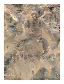
The survey will extend from the west near Mountain Pass, CA, to east of Nipton, NV. It will extend north to the McCollough Range and south to Lanfair Valley. The survey will cover parts of the Clark Mountain Range, Ivanpah Mountain, New York Mountains, Ivanpah Valley, Interstate 15, and the cities of Primm and Nipton, NV.
Residents and visitors should not be alarmed to witness a low-flying aircraft. The airplane is operated by experienced pilots who are specially trained for low-level flying. The airplane is operated by EDCON-PRJ Inc. of Denver, CO, which is working with the FAA to ensure flights are in accordance with US law.
This survey is designed to remotely study the eastern Mojave Desert as part of an ongoing USGS program to better understand the geology, hydrology, and natural resources of the region. The aircraft will carry instruments that measure the earth’s naturally occurring magnetic field, and the new data will help geologists visualize and understand the rock layers below the surface.
