About the author: Timothy R. Lanum is director of communications and development for Wetlands Research Inc. Lanum can be reached at [email protected].
Timothy R. Lanum
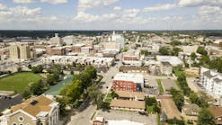
undefinedGurnee is a village in Lake County, Ill., with a population of just over 30,000 people. It borders the city of Waukegan to the east and is considered part of the Chicago metropolitan area. Gurnee is known for a few things. It is the Midwest location of Six Flags Great America; another, perhaps less-well-known fact, is the town’s ongoing effort to battle the Des Plaines River as it rises past flood stage during certain times of the year. This annual threat brings the possibility of millions of dollars in flood damage to the village’s residents and businesses.
A record flood in 1986 caused more than $9 million in damage. More than $1 million was spent in 2004 as the river’s surge overflowed its banks and caused destruction to 44 homes and 33 businesses. During the last week of August 2007, Gurnee once again was challenged with rising floodwater from the Des Plaines River. The threat of flooding, however, was neutralized because of two mitigating circumstances.
The first was a series of floodplain property acquisitions. The second was the completion of a wetland restoration project several miles up the Des Plaines River to the north of Gurnee. The restored wetlands receive and accumulate floodwater, which reduces and slows the flow of water downstream.
“We are extremely pleased with the way the wetlands absorbed water like a sponge and kept it away from our homes and businesses,” said Gurnee Mayor Kristina M. Kovarik. “This was the first time we were faced with a flood threat of that magnitude and had no major damages to report.”
The 550 acres of restored wetlands along the Des Plaines River held back a substantial amount of floodwater targeted for Gurnee during heavy showers in late April 2013—up to 4 ft in some places. This did not eliminate the flooding, but still reduced floodwater volume. If the restoration of wetlands had been repeated along the Des Plaines, Fox and Illinois Rivers, it would have played a major role in reducing the flood damage.
The Project
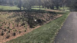
Wetlands Research Inc. (WRI) established the Des Plaines River Wetlands Demonstration Project in Wadsworth, Ill., in the late 1970s, after the state of Illinois commissioned a feasibility study to determine how wetland and river restoration can increase flood control, improve water quality, restore wildlife habitat and increase recreational use. Since that time, a dedicated group of researchers and staff under the guidance of executive director Dr. Donald Hey has worked to transform depleted farmland and stone quarries on the river into a viable living laboratory. The 550-acre site is owned by the Lake County Forest Preserve and was managed exclusively by WRI until January 2013, when the licensing agreement expired.
“In the past, the village would start filling sand bags to protect businesses and homes when the river rose to 7 ft,” Kovarik said. “Now the wetlands displace enough storm water for us to wait until the river peaks at 9 ft before we have to begin that process. What an amazing difference. We had additional hours to get sand bags in place before the river reached any of our homes, businesses or public buildings. We also were able to leave all major traffic routes open.”
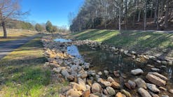
In 2008, WRI finished construction of a large stone riffle structure across a portion of the Des Plaines River to help pool the river into the new wetlands and reduce the flow even more during critical flood periods. The riffle structure plays a vital role in ongoing flood control, but also provides habitat for aquatic organisms and areas for fish to spawn.
A New Way to Manage Nutrients
Hey has spent years studying the effects wetlands have on flooding, habitat and water quality. Recently, he developed the concept of NuFarming, a market-based strategy that uses restored wetlands designed, built and operated for the purpose of managing nutrients, trapping sediments and storing floodwaters. Nutrient farms produce environmental credits—such as nutrient reduction credits—that can be sold to municipal or industrial waste treatment facilities that need to meet a water quality standard and cannot cost-effectively remove the nutrients themselves. NuFarming consists of growing wetlands and passing the contaminated water through the dense vegetation and over the organic soil. The wetlands naturally remove the water’s harmful nitrogen and phosphorous content, which causes water quality issues like the hypoxia in the Gulf of Mexico, for example.
NuFarming could change the economics of land and water for the many towns that border the Mississippi River and reduce their exposure to catastrophic flood damage. Communities along flood-ravaged riverbanks can take their fate into their own hands by adopting the concept of natural flood control.
Gurnee also has adopted a plan through the Federal Emergency Management Agency (FEMA) to engage an incentive program for storm water management. The Community Rating System encourages participating cities and villages to provide extra storm water protection. FEMA has acknowledged Gurnee’s efforts, which included WRI’s wetlands demonstration project. FEMA said that the addition of the wetland retention has dramatically reduced Gurnee’s flood problems and, in the future, will lower the average resident’s budget by reducing the flood insurance premiums homeowners will have to pay.
“I’m reaching out to other villages and towns located in a floodplain to take a serious look at the possibility of restoring wetlands to hold storm water and reduce flood damage costs,” Kovarik said.
Communities located in active flood areas will find that NuFarming can restore wetlands to provide exceptional flood control while improving water quality and wildlife habitat. Wetlands will be a part of our future environmental landscape and can help to solve storm water and flooding issues in the U.S.
Download: Here


