Regenerative stormwater conveyance mitigates flooding in Georgia cemetery
The city of Dalton, Georgia, located approximately 30 miles southeast of Chattanooga, Tennessee, is a community of approximately 35,000 residents. Dalton is famously known as the “carpet capitol of the world” and is home to many of the carpet and flooring manufacturers that outfit indoor spaces worldwide. Located in the ridge and valley section of Georgia, in the foothills of the Blue Ridge Mountains, the terrain is known for its steep ridges draining to wide relatively flat valleys. The unique topographic conditions have resulted in structural flooding, and more frequent nuisance flooding.
Under the leadership of the mayor, who challenged city staff to address the issues, the city set out on a journey to address flooding in a careful and systematic approach. In 2020, the City of Dalton Public Works Department began working directly with Arcadis to develop an actionable and defensible stormwater infrastructure strategy. The city worked with Arcadis to develop a stormwater capital improvement program (CIP). The CIP features an off-right-of-way catalog, which features 31 potential areas of concern, outside of the public right-of-way, identified by the city.
Policy dictated that all corrective action measures to address flooding be performed entirely within the city’s extent of service areas consisting primarily of dedicated easements, public property, and public rights-of-way. However, the city formally adopted an extent of service expansion policy outlining where new easements should be adopted. With this policy in place, the city began exploration of options to address these concerns.
Understanding these constraints, the project team explored solutions for new stormwater infrastructure and best management practices (BMPs) that would capture and convey runoff in the public right-of-way to alleviate these off-right-of-way flooding conditions.
The Walnut North Drainage Basin, located immediately west of the downtown district of Dalton, is comprised of rolling terrain leading to a relatively flat valley. Several projects within the basin were identified in the above-referenced off-right-of-way area of concern catalog, including the flooding challenges located around the vicinity of Ridge Street and Emery Street in the City.
Implementing modeling
To quantify the extent of flooding in “The Ridge Street Drainage Study,” an existing conditions model was developed as a baseline of comparison. The existing drainage system and culverts within the study area were analyzed for their level of service (LOS), with the LOS for the model node junction being defined as the maximum design storm event. This can pass through the model junction while maintaining a maximum computed water surface elevation that is below the surface or structure rim elevation.
A total of 55 analysis points or junctions representing inlets, manholes and culvert headwall locations were analyzed were using PCSWMM to develop the existing conditions and proposed scenarios models.
Challenging conditions like narrow roads and streets, resident access to their homes, and underground utilities made a simple gray infrastructure bypass design difficult to achieve any meaningful improvements in level of service in the area. It was acknowledged that simply increasing the size of the culverts and other pipe systems would likely exacerbate flooding in downstream areas that were already experiencing flooding or would experience flooding as a result. During the preliminary planning phase, several alternatives to alleviate flooding in the area were explored including several bypass iterations with and without storage.
While options that explored conveyance only may have alleviated flooding in some of the identified areas of concern within Dalton, these options tended to move the flooding downstream into areas that either were already experiencing flooding or could be expected to experience flooding as a result.
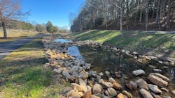
As such, the design team opted for some form of detention to be included in the project. However, with limited open space for traditional detention ponds and an unwillingness to utilize imminent domain to acquire property, more unconventional approaches would be needed. This was achieved using a step pool conveyance system, alternatively known as a regenerative stormwater conveyance (RSC), to reduce flows enough to facilitate the other elements of program. An RSC is a BMP that can be used to restore incised or eroded ditches and channels, ephemeral streams and outfalls. The RSC is constructed with a series of step pools, riffles and shallow pools that help to dissipate energy, promote infiltration, and water quality. If done correctly, these can also be an added visual benefit to the space.
Accounting for location
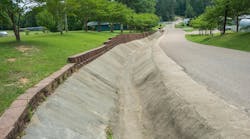
The West Hill Cemetery is located upstream of the area of concern along Ridge Street and presented an excellent opportunity for the RSC with supplemental storage. An existing rip rap-lined channel that drains the upper reaches of the watershed leads to a depressed area to be converted to additional stormwater storage. Ground penetrating radar (GPR) was used in the construction of the RSC, as the conveyance channel and step pools were to meander through a cemetery with headstones that date back to the civil war.
Originally, the design was completed specifying rip rap stone so that a portion of the existing material in the existing channel could be reused; however, with the practice being in a cemetery, an increased emphasis on the character and appearance of the feature was a focus of the design. To accomplish this, Tennessee field stone sourced in the vicinity was used for the riffles instead of rip rap stone due to its attractive natural appearance in the landscape.
During the design of the RSC, the design was optimized using PCSWMM stormwater modeling software to determine system hydraulics through the practice and downstream within the watershed. The existing depression area immediately downstream of the RSC was also improved for supplemental storage. An outlet control structure was designed and installed, and storage volume was optimized through minor regrading and excavation in the area.
The discharge from the RSC and detention pond are then directed to a newly installed storm sewer line which incorporated a bypass line to bring runoff flows though the right of way and bypass existing channels and culverts located within several backyards which experienced significant flooding.
Since construction completion
With construction completed on the RSC in 2023, the area of concern downstream of the RSC has already seen significant improvements in levels of service, with some stakeholders commenting “do we really need to complete the remainder of the project?” The second phase of the project was completed in 2024, which consisted of construction of a by-pass drainage system that transferred stormwater around the homes. Because of the investments in the RSC, the city was able to build this system without flooding downstream areas along W. Franklin Avenue. Future improvements along W. Franklin Avenue will also be facilitated by the reductions realized by the RSC in 2025.
Also, planned for 2025, the final detention component of this effort is planned on an adjacent tributary of the same drainage basin. A local synagogue and its campus were recently donated to the city. The city intends to construct a small regional detention pond on the site to help reduce flows in the watershed that will also double as a greenspace for the public. As part of the design, a heritage park will be built into the plans to illustrate the contributions of the Jewish community to Dalton and the carpet and flooring industry that they helped build.
About the Author
Michael DeVuono
Michael DeVuono, PE, is national practice lead of Stormwater Design and Engineering at Arcadis.
Richard Greuel
Richard Greuel is principal water engineer at Arcadis.
Alexander Carlson
Alexander Carlson is a project water engineer at Arcadis.


