Forecasting the future: The Charles River Watershed flood model mitigates regional flood challenges
Climate change has already resulted in significant weather impacts, including extreme precipitation, heat waves, more frequent drought, sea-level rise, storm surge and inland flooding. According to the 2023 Fifth National Climate Assessment Report, the Northeast has seen an increase in precipitation in all seasons, and between 1958-2021 extreme precipitation events (defined as events with the top 1% of daily precipitation accumulations) have increased by about 60%, which is the largest increase in the US[1]. Also, according to the 2023 Resilient Mass Plan, environmental justice and other priority populations who live near commercial and industrial buildings have a 57% higher risk of flood damage than the rest of the Commonwealth[2]. Adapting to this continually changing climate requires significant effort and investment. Understanding the impacts of climate change is a key component of adapting: the better we understand the impacts, the more prepared we will be to address them.
Historically, many entities have relied on mapping prepared by the Federal Emergency Management Agency (FEMA) to predict where flooding will occur. Climate change, however, is making FEMA flood maps an inadequate or incomplete tool. In Massachusetts, the Charles River Watershed Association (CRWA) has adopted a unique approach to flood mapping that can serve as a model for other parts of the country to follow.
The Charles River Watershed
The Charles River, also known as the Quinobequin in the traditional territory of the Massachusetts, Wampanoag, and Nipmuc Nations, springs from its source about 30 miles southwest of Boston and flows through 23 communities. Its watershed, encompassing more than 300 square miles and 35 cities and towns, is home to just under a million people. Past efforts at addressing flooding issues throughout the watershed have largely been undertaken on a piecemeal basis and have had limited benefits at a watershed scale, including limited assessment of flood mitigation impacts upstream and downstream of the project location at the watershed scale. Flood mitigation projects rarely consider future storm projections.
CRWA recognized that taking on the challenges associated with flood mitigation requires a more proactive and collaborative strategy. Seeing a need, CRWA led the formation of the Charles River Climate Compact (CRCC), a voluntary partnership of about two dozen municipalities, to address flooding at a regional scale — the critical scale for addressing flooding.
The CRCC, led by CRWA, working with technical partner Weston & Sampson and resident engagement specialists at Communities Responding to Extreme Weather (CREW), prepared the Charles River Climate Adaptation Flood Mitigation Implementation Plan (Plan). The Plan provides an overview of the development of the Charles River Flood Model (CRFM), a computer model which estimates where and when flooding is likely to occur as our climate changes. The CRFM can also be used to evaluate the potential impact of regional and large-scale flood mitigation actions before making investments and policy decisions.
Model Development
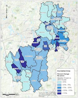
The CRFM’s geographic extent covers all or part of 33 municipalities, a total area of 273 square miles, and is focused on the upper and middle Charles River watershed. The cities of Boston and Cambridge, which border the Lower Charles River Basin, already have detailed flood models demonstrating the impacts of flooding in their communities, and hence are not included in the current version of the CRFM. The CRFM is built to simulate the integrated impacts of stormwater flooding, from both riverine (fluvial flooding) and drainage infrastructure (pluvial flooding) and factors how the flood pathways in the watershed are impacted from the built environment.
The team ran two broad categories of modeling scenarios for existing baseline climate and potential future climate scenarios across the full model area:
- No-action scenarios represent potential flooding that will occur if no actions are taken to mitigate flooding and no changes occur across the watershed landscape, i.e., assuming current land use and existing infrastructure conditions.
- Flood mitigation (or Action) scenarios assume changes in landscape (such as changes in percent imperviousness), and/or other flood mitigation activities (such as stormwater retention and increased flood storage).
The same rainfall/storm events were applied to both scenarios to compare the flood mitigation strategies’ benefit on reducing present-day and projected future flooding due to climate change.
Multiple storm sizes (e.g., 2-year, 2-hour design storm, 10-year, 24-hour design storm) and future planning horizons (present day and 2070) were simulated in the model. The storm types and planning horizons selected were informed by CRCC input and by public input via online surveys. The CRCC expressed their preference for viewing results for longer-term planning horizons and more severe events, in line with planning horizons for infrastructure investments; however, the public expressed their preference for shorter-term planning horizons, such as 30 years, more in line with what an individual may expect to see in their lifetime.
Future rainfall projections were developed following the latest recommendations and data adopted in the Climate Resilience Design Standards Tool championed by the Resilient Massachusetts Action Team (RMAT)[3]. The projections in the tool have been developed by Cornell University as part of the Massachusetts Executive Office of Energy and Environmental Affairs’ 2021 Massachusetts Climate and Hydrologic Risk Project[4]. These projections are available at the same spatial resolution as the NOAA Atlas 14 data. Since the CRFM covers a relatively large geographic area, the team assessed spatial variability of future rainfall projections for the watershed to check how rainfall amounts and storm sizes vary across the watershed sub-basins. However, since the maximum spatial variability in rainfall projections among the sub-basins is within 5%, basin-wide area-weighted average rainfall projections were used for consistency and simplicity in comparing results across the watershed.
Baseline climate scenarios
Design storm rainfall depths for baseline climate were derived from NOAA’s Atlas 14: Precipitation-Frequency Atlas of the United States for Stormwater Management (NOAA 14), which represents the industry-standard design rainfall depths for events under a late 1900s/early 2000s (baseline) climate condition. Select design storms were presented for the 2-,10- , 25-, 100-, and 500-year recurrence intervals. NOAA 14 design rainfall depths associated with these events represent the watershed area-weighted average values, which were estimated by weighting the NOAA 14 values for each community based on the percentage area of the community that falls within the study area.
Future climate scenarios
To evaluate future design storm depths, the team used Intensity Duration Frequency (IDF) projections from Cornell University developed as part of the state’s Climate and Hydrologic Risk Project4. These IDF curve projections are available for each 0.5 °C warming, starting from 0.5 °C to 8 °C. The annual average temperature change for the watershed is projected to be 2°C, 3°C, and 4.5°C for the 2030, 2050, and 2070 planning horizons, respectively. A comparison of the 24-hour design storms for the watershed between the present-day NOAA Atlas 14 values and the future projections by the 2030, 2050 and 2070 planning horizons for the 2-yr, 10-yr, 25-yr, 100-yr and 500-yr return periods are presented in Table 1.
Table 1. Proposed 24-hour design storm rainfall depths for future scenarios used in the Charles River Flood Model
*Note the CRFM has been run for the 2-yr, 10-yr and 100-yr return periods for the 2030 and 2070 planning horizons.
Based on these projections, today’s 100-yr storm (or a storm that has a 1% annual chance of occurring in a given year), which corresponds to 8.19 inches, is likely to be approximately a 25-year storm (or a storm that has a 4% annual chance of occurring in a given year) by 2070. In other words, what is a rare event in today’s climate will become a more common event within the next 50 years. Similarly, today’s 25-year storm, which corresponds to 6.39 inches, is likely to be a 10-year storm by 2050.
Flood mitigation scenarios
The CRFM showed that the extent and depth of flooding from typical and extreme rain events will be much worse by 2070. As noted above, the team identified flood mitigation scenarios that will allow communities to begin to adapt to the expected flooding impacts from climate change. These regional watershed-wide flood mitigation (action) scenarios included:
- Implement green stormwater infrastructure to collectively capture and store/infiltrate the 2070 2-year storm event (4.5 inches) from half of the impervious cover in the watershed
- Create significant storage (greater than 4 inches for 24-hour storm) on large impervious (>5 acres) parcels
- Reduce impervious cover
- Manage large ponds (greater than 20 acres) to store flood waters
- Restore or expand wetlands; and
- Dam removal
In addition to the flood mitigation scenarios above, a comparison simulation was conducted to simulate the effects of developing land that is currently undeveloped and unprotected with and without stormwater mitigation measures to understand how future development will further contribute to flooding.
The most favorable solution was capturing/storing the 2070 2-year storm event from half of the impervious cover in the watershed using green stormwater infrastructure, a feat that is a significant undertaking.
Pathway to implementation
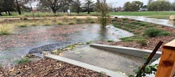
The initiative also identified more than 50 priority sites with opportunities for individual flood mitigation projects across the watershed that provide both localized and regional benefits, including co-benefits related to reducing urban heat, creating ecosystem habitat, and improving water quality. Concept designs, developed with public input, included:
- Adjustments to pond outlet structures to allow the pond elevation to be raised or lowered to
accommodate anticipated storm events - Earthen berms to protect residential properties
- Removal of urban fill from wetlands to increase their storage capacit
- Green infrastructure stormwater treatment systems (bioswales, bioretention, permeable paving) to improve water quality
- Wetland restoration
- Combined green infrastructure and underground stormwater flood storage
The Plan laid out an implementation pathway for each project, with public engagement being critical. The team has involved numerous residents and integrated other ongoing planning efforts to continue this stakeholder collaboration going forward. There was and continues to be a focus on integrating input from climate vulnerable population groups.
This multi-year, ongoing effort has resulted in identification and multiple projects and strategies, as described above, that communities can begin to act on to build resilience and protect vulnerable residents. As a large-scale, regional effort, the group has also developed broad recommendations for the team which can be readily applied to other regional efforts, these include:
- Planning recommendation: set flood reduction targets to avoid chasing impossible goals
- Aggressive actions are needed
- Select and take actions matched to the local landscape, locations in the watershed, and community priorities
- Combined & layered solutions: no one action is likely to be a panacea
- Target new and re-development
- Continue to seek local improvements like priority projects identified in the plan
Award winning
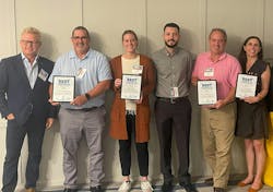
Due to the project’s success thus far and the promise it holds for future flood prediction, the New England Stormwater Collaborative named the CRWA and the Town of Natick, the municipal sponsor and grant lead, as co-awardees of its 2022 Stormy Award for “The Best Stormwater Idea in New England.”
The project team will continue this initiative to better understand future flooding and the actions that can be taken to address it and work to implement these actions on the ground. This work was funded by the Massachusetts Municipal Vulnerability Preparedness (MVP) program, and we are grateful for their support.
1 USGCRP, 2023: Fifth National Climate Assessment. Crimmins, A.R., C.W. Avery, D.R. Easterling, K.E. Kunkel, B.C. Stewart, and T.K. Maycock, Eds. U.S. Global Change Research Program, Washington, DC, USA. https://doi.org/10.7930/NCA5.2023
2 https://www.mass.gov/doc/resilientmass-plan-2023-executive-summary/download
3 Massachusetts Climate Change Clearinghouse. “Climate Resilience Design Standards & Guidance.” Accessed February 22, 2024. https://resilientma.mass.gov/rmat_home/designstandards/
4 Steinschneider, S., & Najibi, N. (2022). Observed and Projected Scaling of Daily Extreme Precipitation with Dew Point Temperature at Annual and Seasonal Scales across the Northeastern United States, Journal of Hydrometeorology, 23(3), 403-419. https://journals.ametsoc.org/view/journals/hydr/23/3/JHM-D-21-0183.1.xml
About the Author
Indrani Ghosh
PhD
Indrani Ghosh, PhD, is a Senior Technical Leader in the Climate Resilience Practice at Weston & Sampson in Boston, Massachusetts. She leads regional resiliency projects across the Northeast and specializes in translating climate change projections to engineering design criteria for new and existing infrastructure. Indrani can be reached at [email protected].
Julie Wood
Julie Wood is the Climate Resilience Director for the Charles River Watershed Association. She helped found the CRCC in 2019 and runs the compact. Julie was instrumental in developing the CRFM She can be reached at [email protected].
Janet Moonan
PE
Janet Moonan, PE, is a Senior Project Manager in the Water Resources group at Weston & Sampson in Reading, Massachusetts. She leads interdisciplinary planning, design, and construction projects that improve water quality and mitigate flooding and has a passion for employing nature-based solutions. Janet can be reached at [email protected].


