Several tributaries bring water to the main stem of San Luis Obispo Creek, which flows right through the middle of downtown San Luis Obispo, CA. With a population of close to 50,000 residents, the San Luis Obispo Creek watershed covers approximately 84 square miles. Also located in the city is Laguna Lake, a natural feature fed by creeks that are running through the city. Freddy Otte, biologist for the City of San Luis Obispo and the project lead for the Let It Be project, says that one of the tributaries was rerouted through the lake back in the 1950s, creating a legacy of sediment issues. The city is hoping to take on these issues in the near future through the Laguna Lake Natural Reserve Conservation Plan. As part of the plan, the city is considering dredging and using compost-based filters to remove sediments from stormwater before it gets into the creeks. However, a more immediate problem recently came into focus for Otte at a stormwater outfall in a less urbanized part of the city that was experiencing active erosion.
Rooting Out a Clogged Drain
Otte explains that the area had two 48-inch storm drains “in a more remote area of the city” that eventually flow into a local creek that feeds Laguna Lake. Installed decades ago, these outfalls had become clogged with sediment over the course of many years of development in the watershed. Otte believes much of that sediment accumulated during building booms that occurred as the watershed went through a transformation from rural farmland, ranches, and forest to its current more urbanized state. In an era before protective sediment control regulations such as the Clean Water Act went into effect, he says, when developers cleared the land, they would typically leave it bare in anticipation of construction. Inevitably, erosion would occur in the interim.
He recently worked on refurbishing an outfall on a Let It Be site as part of the city’s open space program. The outfall is a tributary to Laguna Lake, and the outfall pipes drain high-density residential neighborhoods into a compact basin. The basin is designed to direct the stormwater it receives to a field, where its velocity is slowed before the water drains into a nearby creek. Otte says maintenance on this infrastructure is critical to prevent flooding in the developed portion of the drainage area.
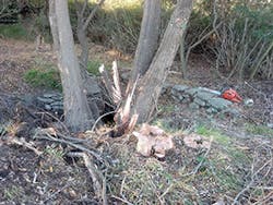
The pipe had been silted in and buried in up to 4 feet of sediment. Sediment had filled in much of the pipe’s volume, reducing it to 20% of its capacity. Nature, however, complicated the mess decades ago, seeding a volunteer directly in front of the outfalls. The seedling eventually matured into a multi-trunk willow tree whose roots, tangled with sediment, almost entirely clogged one of the 48-inch culvert pipes.
The project consisted of uncovering the silted infrastructure, removing vegetative obstructions from the drainage basin, protecting the walls of the basin, and redirecting the flow from the outfalls into the nearby field. Achieving this would require the stormwater to “take a hard, almost 90-degree turn,” just beyond the outlets of the 48-inch pipes, he says. From there, the runoff would be channeled to the field to slow its velocity and allow for infiltration before it eventually reached the lake.
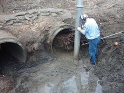
“We had to dig down through four feet of silt just to get to the bottom of the storm drain pipe,” says Otte. The roots of the willow had formed a tangled mass in the storm drain that had to be removed as well. Technicians used the jet from the city’s Vactor vacuum truck, he says, to pressure-wash sediment out from within the drainpipe, beyond the rootball, loosening the root cluster. Then they hooked onto it with a cable and used the vehicle’s winch to haul it out. “It was like a cork—just like a big solid plug of roots and sediment. It was quite a bit of work,” he says.
“Once we were able to dig down almost four feet, we hit a concrete sill. We incorporated that and went six feet further downstream so that we had a relatively good-size basin, probably about 10 feet across, to be able to accept the amount of water coming down the storm drains, but also small enough to be able to wrap that water to do a hard 90-degree to the left so the water can flow out into the field.”
The decision to make a sharp turn in the outlet channel was to avoid directing the discharge from the double-barrel pipes into a channel aiming straight out into the field, which would have impacted stands of trees and native shrubs that had become established downstream. He notes, however, that some form of erosion control was needed to armor the banks of the basin against the impact of stormwater rushing from the outfall. After evaluating several potential solutions, including cinder block walls, poured-in-place concrete retaining walls, and shotcrete, Otte selected Milliken Concrete Cloth because of its ease of installation, manageable costs, and advice from consultants familiar with the performance of the product.
“We needed something that was hardscape, because you’ve got a lot of velocity coming down those 48-inch storm drains. On that gently graded downslope where you’ve got water that’s accelerating as it comes down, we had to make sure we had something that was really solid on the backside,” he says.
“We had thought about a cinderblock wall, but that would have required a footing, so we’d have to over-excavate, and cinderblock walls don’t wrap around very well, so there would have been more angles and it would have just been more challenging.” He says the option of a poured-in-place concrete retaining wall posed similar challenges, requiring a footing and building a form. “We considered shotcrete as well, which would have been similar to the Concrete Cloth, but you’d have to get a concrete truck out there to be able to spray it on and have something like a hog-wire form that would be able to wrap around.”
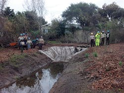
By contrast, he says, Milliken Infrastructure Solutions’ Concrete Cloth “was easy to work with. It was basically just unrolling it, cutting it to length, shaping it to form, and tacking it in with landscape staples and you were done. I didn’t have to get a permit because it wasn’t a retaining wall over four feet tall. It was really just erosion control that came on a big roll.”
Estimating that the product he used was about half an inch thick, he says, “It’s thin enough that two people can work with a large piece to get it in place and staple it. Then you hose it down and it cures in place.”
It was important to obtain a smooth contour and a good fit as the concrete cloth molded to the basin. “As we were going through, we shaved off the edges of the basin to make it as smooth as possible so there weren’t big voids,” he says. “We used sandbags to keep it taut against the edges. Once it’s in place, when you hose it down it’s going to solidify to that form. Outside of a catastrophe where everything washes away, it’s going to hold up pretty well. You could probably hit it with a hammer and it’s not going to puncture or tear. It’s almost like a rug—if you think about how competent a rug is, with all the fibers and whatnot, the Concrete Cloth would be the same way.”
Since it was rebuilt in 2014, says Otte, the outfall basin has stood the test of a range of storms. “We’ve had some big events and it’s held up well. Based on the storms that we’ve had, we haven’t had a problem down there.”
Although this was his first experience using Concrete Cloth, Otte calls it “an amazing product,” saying that if circumstances arose he would “absolutely” use it again. He does, however, offer a note on working with the product around bodies of water. He cautions, “It is still concrete, so as we were hardening it, we ended up vacuuming out all the water that we used to spray down the Concrete Cloth, because that’s got pH issues and other water-quality issues. We vacuumed out that water to prevent it from going into Laguna Lake.”
Total cost of the project was about $20,000, with the biggest cost being the product itself and city staff from the Administration, Public Works, and Utilities departments who collaborated to complete all components of the project. “The basin has performed as expected. We are very happy to have completed this project and look to use this as a model for other storm drain outfalls in the city,” says Otte.
Arresting a Slide on Highway Patrol
Matt Veerkamp, vice president of Doug Veerkamp General Engineering Inc, has been on patrol while working in the area of Highway 50 near Fresh Pond in California for over a year. He’s working on a California Department of Transportation (Caltrans) contract to repair slopes damaged by intense storms in 2015. A slope between the highway and Dubasary Lane had been showing signs of failure after the road settled that very wet winter. After monitoring its progressive failure for about three months, says Veerkamp, “We had to go in there and do something about it.”
Describing the nature of the failure, he says the toe of the 75-foot-tall slope “was washing away from underneath.” He estimates the extent of the failing area as about 100 feet in length with a 1.5:1 incline. “The whole thing was washing away; the highway was becoming unstable due to the material washing downhill, and it needed to be stabilized,” he says.
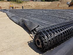
Shutting down one lane of road at a time, crews working with nothing heavier than excavators because of the steep pitch of the slopes took down all the overburden and then rebuilt the slopes “from the bottom up with dry competent material,” says Veerkamp. The slope was covered with GeoWeb, a cellular confinement system from Presto Products, and then vegetated.
The excavator, working from a flat surface, cut 12 feet into the slope “and then just built that up with fill all the way to the top using the bench method of making a compacted engineered fill.” Crews compacted soil that had been benched in to the existing soil and stretched the GeoWeb over it “like a blanket,” says Veerkamp. With the slope restored to its original topography, he says, “We just went to a landscape place and ordered a topsoil with nutrients that something would grow in, laid that in there, and gave it a shot with a Caltrans erosion control mix of accepted grasses indigenous to the area.”
Veerkamp believes that Caltrans specified GeoWeb because of its ability to hold the topsoil in place. “I think they like how you could put topsoil in it and it could grow vegetation while it can be anchored from the top, to prevent it falling down the slope.” He says that within a month the slope was 70% vegetated, which he considers “a very good result.”
“It was my first time working with GeoWeb. I had a crew of a foreman and three laborers that installed it, and placing the material on and raking it in was really easy. It came on pallets. It’s flat like an accordion, and you pull it all out and stake it in the ground. I would recommend using it again because it’s super easy and it works,” he says. “It’s been two years now. I’ve been up there several times and it’s stable. I’m always on that route, so I see it whenever I’m up that way, but there’s no reason for us to be monitoring it any more except to just check it out to see how it is,” he says.
A High-Tech Land Bridge
Waterloo, ON, has experienced rapid growth in recent years. It is becoming a high-tech hub, home to BlackBerry and the University of Waterloo, a leading Canadian public research university with prestigious programs ranging from mathematics to its School of Environment, Resources and Sustainability. It is also a nice place to live; as 20-year resident Darren Scott, senior project engineer for the City of Waterloo, notes, “It’s a great city. There are lots of things to do, lots of recreation.”
He says the city has been growing fast for the past several decades. “The universities help that a lot in the tech sector. There are a lot of startup businesses here in Waterloo.” In spite of the focus on a fast-paced economy, he says, “With the Grand River going through town, there is also a lot of interest in the environment. With the projects I work on there is always a component that focuses on concerns people have with the environment.”
One recent project—repairing and modernizing a road connecting the booming west side of Waterloo with the rest of the town—highlights an innovative approach to preserving the environment while bringing new transportation and recreation opportunities to the city’s residents.
West Columbia Street passes through a low-lying area of Waterloo, traversing a stretch of a wetland designated as Provincially Significant while serving as a major conduit for east-west traffic. With the expansion of residential, commercial, and institutional development in various parts of the city, this formerly rural road was in need of upgrades and renovation. Resting on unstable wetland soils with a substrate of saturated peat, the road had suffered significant deterioration.
The hydrological connection between the two sections of the wetland on the two sides of the existing road had been maintained by two culverts passing under the travel lanes. According to Scott, the city sought to expand the road from two lanes to four lanes, with upgrades to handle increased traffic and meet contemporary standards.
When modernized to connect new residential and commercial development to the rest of the city, it was planned to include—along with the two additional vehicular lanes—an active transportation lane for cyclists, a median strip, and a sidewalk to increase accessibility for pedestrians. The challenge was to bridge the environmentally sensitive area and provide a stable, durable road, keeping the neighborhoods connected while preserving the integrity of the wetlands.
A raised roadbed runs through the wetland area.
Rising From the Mire
As the road descended into the wetland valley, its topographical dive obscured sight lines, reducing visibility for motorists. One of the project goals was to address visibility by raising low-lying sections of the road through the 1.2-mile stretch across the wetlands, to facilitate a safer, more comfortable drive.
Early concepts for a new crossing envisioned a bridge structure on deep piles. “It would have entailed an extensive structure,” says Scott. However, he explains that, because the “organic material is quite deep at that location,” the prospect of driving piles deep enough to anchor a bridge became a concern in terms of both time and expense.
According to Scott, due to the technical complexities involved, building a bridge across the wetland would have required at least two construction seasons to complete. City officials, not eager to burden motorists and residents with the prospect of long-term construction delays, wanted a more compressed construction timeframe. Furthermore, with an estimated cost of around $13 million, the financial feasibility of constructing a bridge became questionable.
Rather than wrestle with a trestle, the decision was made instead to raise the roadbed by about 2 meters and reconnect the two sides of the bifurcated wetland through upgraded culverts embedded beneath the road. However, the same organic material that posed a challenge for bridge construction also posed an obstacle for the elevated roadbed. Subsurface peat deposits would be subject to settlement under the pressure of the road. Because of the loose organic material and saturation of the wetland area the road would cross, a reinforcement system would need to be installed to ensure roadway integrity.
To achieve and maintain a stable surface at final grade, it would be necessary to consolidate and stabilize the saturated soil deep below grade. Geotechnical engineers advised preloading (surcharging) the entire stretch of the road right of way with fill to an elevation 1.5 meters above final grade. Francis Reyes, manager of development engineering for the city, explains, “One of the tricky portions was that there was a significant amount of peat content in the soil. They were basically unsuitable soils, so we needed to install geotextile fabric to provide the additional support for the loading on top.”
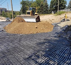
He says, “We had to look at options of how to strengthen that area, and we settled on Maccaferri.” Maccaferri’s ParaDrain geogrid was rolled out every half meter of lift approaching the final grade. To provide the needed compaction for the completed road, the additional surcharge of 1.5 meters of fill was placed on top of the bed, and the long pile of earth was left to stand for several months as technicians monitored it for settlement.
“In the lifts of compacted material, we installed small metal plates at various locations so we could monitor over time how the road was reacting,” explains Scott. “Engineers monitored the area as it settled to ensure it had reached equilibrium and had stopped settling under the weight of the fill before removing the excess fill and prepping the surface for final grade.”
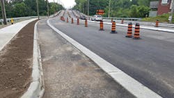
Because two new lanes were being added, says Scott, it was possible to keep the traffic flowing throughout the winter while the road settled, a critical goal of the project. “It was a bit of a ballet act. It’s a major road commuting from east to west. We temporarily paved one half of the road to allow one lane to travel in each direction throughout the winter.” During that time, construction was paused and the new upgraded lanes were allowed to settle. When the fill had stabilized, construction resumed, culminating in the placement of base asphalt on the two raised lanes. At that time traffic was routed to the alternating lanes and the process was repeated on the other half of the road, stripping and preloading the bed with lifts of fill sandwiched between Maccaferri ParaDrain.
Scott says that by tying into a broad cross section, the ParaDrain geogrid stabilized the road so that no further settlement would occur after the point of equilibrium. In the spring, crews stripped off the 1.5 meters of temporary fill used for compaction. Although Scott says that with the thaw “there was a little more settlement,” he concedes, “That was expected by the geotechnical engineer.” However, he says, the way the geosynthetic material “is weaved together and meshed into the road base, you wouldn’t have a localized area that would suddenly see some extreme settling.” To give it added strength, he says, “It’s tied back into the areas that weren’t within the peaty area.”
Constructing a crossing at grade using ParaDrain reinforcement cut the cost of the roadway improvement across the wetland to just $9 million, saving the municipality around $4 million compared to the bridge concept proposed early in the planning phase. “It was a good experience. The product fit our needs. Maccaferri staff was onsite if we had any questions about how the grid would react,” says Scott. In the spring and summer, all lanes were opened for traffic. The only task left to complete was laying surface asphalt. “The area over the creek where the geogrid was used looks good. There are no concerns at all at this point,” he says.
“We needed to use that geogrid to build the road without a bridge. There was no other way. The road through that area without the geogrid wouldn’t have been possible.”
