Protecting community and the environment: Lebow Creek Stream restoration project
In Fort Worth, Texas, a vibrant metropolis pulsating with life, change is constant. As the 13th largest city in America, Fort Worth is part of a trend seen in many cities across the Lone Star State, a population growth that continues transforming communities. With this surge in residents comes an inevitable strain on a vital resource that keeps the city flowing smoothly: its stormwater management infrastructure. City officials, keenly attuned to the challenges posed by this growth, recognize the urgent need to fortify and innovate within their existing systems to ensure the resilience of Fort Worth.
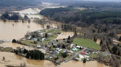
Increased urbanization has changed the characteristics of stormwater runoff within the city, impacting the community’s natural receiving streams. Further complicating urbanization is that development occurred before local floodplain regulations were adopted. This phenomenon has resulted in flood damage and erosion along Lebow Creek, an urban channel in north central Fort Worth. Lebow Creek captures and conveys floodwaters away from well-established neighborhoods dating back to the 1960s. The adjacent neighborhoods have been plagued with repeated roadway overtopping and channel erosion, threatening the city and Texas Department of Transportation (TxDOT) roadway facilities. Roadway overtopping is an increasing safety risk to motorists and pedestrians with multiple fatalities recorded in the Lebow area between 1986 and 2004.
Specifically, this location has multiple documented high-water rescues associated with the culvert crossing at 28th Street and the nearby sump under the railroad. Recognizing these hazardous conditions, the city of Fort Worth developed a schematic design plan for the entire watershed. Implementation of the plan started in 2002, with the goal to increase the flood conveyance capacity to reduce flood risk to the community, restore the channel, and enhance the environmental benefits of the channel.
Addressing flood issues
In 2020, Fort Worth initiated the Hazardous Road Overtopping Mitigation (HROM) program to address unsafe road crossings caused by flooding. Expected to continue through at least 2025, this program identifies low-water crossings and implements safety measures such as closures, warning signs and flashers, and culvert replacements to reduce flood risk.
Lockwood, Andrews & Newnam (LAN) Inc. was tasked with designing and overseeing the construction of improvements at 28th Street and Decatur Avenue, funded under the HROM program, at Lebow Creek. The project focused on enhancing approximately 1,500 linear feet of the Lebow Channel, particularly around the SH 183 (NE 28th Street) bridge. The main challenge was to convey the 100-year storm under 28th Street and decrease water depth over the roadway during storm events while providing additional flood storage for more severe storms, all while addressing erosion issues threatening Decatur Avenue. Prior to this project, in 2011 the City and TxDOT improved the culverts under 28th Street but filled in the bottom of the culverts until the channel work could be completed.
One crucial aspect to consider is the inherent dynamism of streams, a stark contrast to the static nature of stormwater pipes or manmade channels. Streams can remarkably adapt their characteristics to maintain equilibrium, often resulting in erosion or sediment deposition in undesirable locations. This natural behavior poses risks to nearby structures and may cause the stream to veer from its established course.
In this case, the existing conditions of the channel banks were severely eroded, posing a direct threat to adjacent roadway infrastructure. Decatur Avenue experienced overtopping during a 2-year storm event, while the Northeast (NE) 28th Street bridge faced overtopping during a 10-year storm event. Upstream of NE 28th Street, the channel was narrow and shallow, transitioning into a concrete-lined channel downstream of the crossing.
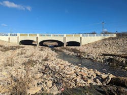
These channel conditions impaired the floodwater conveyance during major storm events, leading to further erosion along the channel. The goal of the Lebow Channel improvement project was to maintain the new structure, improve conveyance capacity and stabilize the crossing, which serves as a pinch point in the channel. To maintain the new structure, structural engineers were consulted so that lowering the channel thalweg through the crossing would not jeopardize the stability of the bridge footings. The project introduced rock riprap armoring upstream and downstream of the crossings as countermeasures for the increased velocities through the bridge.
Creating cohesive goals
The restoration of the channel encompassed four primary goals: flood mitigation, channel stabilization, water quality and ecosystem uplift. These goals must complement each other to accomplish dynamic results — all of which must be achieved within a limited footprint and without creating downstream impacts.
Approaching a channel project starts with analyzing existing conditions through desktop data collection, followed by an initial assessment of stability and flood conveyance within the channel. The next step is the field inspection of the geomorphic composition or natural features of the earth’s surface in the field. While on-site, several elements need to be considered:
- the riparian or native vegetation;
- the stream bed composition; and
- the presence of any additional stream features such as pool, riffle and run sequences.
A naturally formed channel has each of these characteristics, and at times, several of them, as it naturally adjusts to its surroundings and increases urbanization.
Fusing natural elements with permits
LAN developed a design plan that included natural channel design, grade control structures and armoring to stabilize the proposed channel and additional flood storage to convey the 100-year storm event. The natural channel design began with removing the existing concrete-lined channel, bridge abutments, and previously armored sections of the channel.
The initial design challenge was to incorporate a form of natural erosion protection to meet the USACE’s permit for the project. The permit required the existing channel to be benched with a wider section to provide flood risk reduction. It also required a meandering low-flow channel, native trees and vegetation on the banks to restore a natural riparian zone for the stream.
Another aspect of this project was to coordinate the city-led channel project with a separate project led by TxDOT. The TxDOT project improves drainage at the railroad sump on 28th Street and outfalls into Lebow Creek. This coordination will result in a flood depth reduction at the railroad sump. To accommodate the new outfall, LAN designed stone riprap to armor the outfalls.
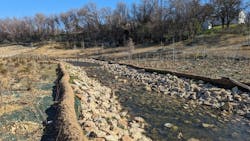
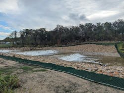
Fort Worth acquired one lot west of the channel to allow for the benching and widening on the north side of NW 28th Street and added volume for the flood events. Using a stone rip rap provided natural armor for the pilot channel. Turf reinforcement matting was used to protect the natural vegetation and trees established along the banks for restoration of the native vegetation present.
To restore the natural riparian zone, the use of live staking versus caliper inches of the trees was implemented to avoid the loss of trees in the channel as the city had experienced in the downstream portion of the project. This live staking process involved the branches of native trees being cut while dormant and planted directly in the soil. This process stabilized and modified the soil along the banks while all the remaining vegetation became established in the riparian buffer zone. The project placed mor than 3,800 live stakes to establish the required coverage to meet the USACE permit and the city arborist requirements. In addition to the channel’s natural armoring, stone rip rap was used on the abutments of the bridge structure and along the banks of the meandering pilot channel.
The schematic design included grade control structures and an analysis of the sediment transport in the channel at the upstream end project limits, a grade control structure was used as the stream flowed into the project area.
The grade control structure used a drop structure, a pool and another drop structure to transition the channel bottom slope to the meandering pilot channel. These provided both erosion protection and reduced the velocities within the channel. The use of several riffle structures, pools, and run series in the meandering channel mitigated the sediment transport previously present in the stream.
In conclusion
Construction of the improvements at 28th Street were substantially completed in early 2024 and the first spring growth season is in full swing. Several substantial rainfall events occurred during construction, demonstrating the stability and utility of the design during peak events as well as base flow conditions.
With these improvements, pedestrians and motorists alike will pass through the area more safely. The channel is both stable and provides ecosystem uplift within the stream corridor.
About the Author
Kimberly Cornett
Kimberly Cornett, PE, CFM, F. ASCE, specializes in complex drainage systems involving hydrologic and hydraulic modeling and design. Her experience spans analysis for feasibility and preliminary engineering to construction in order to provide flood risk reduction projects to her clients. She develops improvements through channel revitalization, storm sewer improvements, detention basin improvements, and construction management. With over 25 years of experience, Kimberly is a strong program and project manager with a demonstrated history of working in the civil engineering industry.
Mathew Busby
Mathew Busby, PE, is a public works team leader in Dallas, Texas whose career has been defined by a commitment to designing and constructing public works and infrastructure projects that connect communities and improve lives. With more than 13 years of experience developing solutions for municipal clients, his diverse background in procurement, design, and construction enables him to integrate project goals with a big-picture perspective. As a design engineer, Mathew has been responsible for utility relocations, pipelines, pumping stations, and treatment plants.
Laura Casset
With more than 20 years of experience serving public clients in stormwater and floodplain management, Laura's background includes civil engineering design of flood mitigation projects, surface water hydrology/hydraulics, identifying project funding opportunities, grant application development, Federal Emergency Management Agency (FEMA) map revisions, and transportation drainage projects throughout central and south Texas. She is committed to working closely with jurisdictions in need of project funding support to ensure that their projects are implemented.


