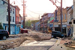
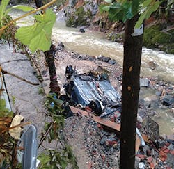
Two people were swept downstream and died during a catastrophic flash flood that struck Ellicott City, MD, on the evening of July 30, 2016. The infrastructure designed to carry stream flow and storm runoff along Tiber Run, which runs through the historic district, was unable to meet the demands of the 1,000-year storm event that produced 6.6 inches of rainfall in a three-hour period, according to a local National Weather Service (NWS) rain gauge. The unprecedented storm event caused damage never seen in the area before. Roads were literally washed away, and more than 200 vehicles were damaged, many parked in a public lot. Twenty vehicles washed into the Patapsco River, and one was deposited nearly a mile downstream. Several people required rescue and were evacuated from the area by responding fire and rescue personnel.
It is not known at what point during the storm it happened; however, at least one dam within the watershed failed, briefly increasing the flash flood with stored rainwater rapidly being released through the embankment breach and into the downstream waterway. Designed to treat and manage runoff from a residential subdivision, the facility did not store a significant volume compared to the total watershed; nevertheless, the untimely release of unregulated runoff likely did not help downstream conditions.
Storms of this magnitude are uncommon, but when they occur the damage is extraordinary. The power of water is relentless, and high-velocity flow has the ability to convey enormous volumes of water in moments. The civil engineering community is deeply challenged with designing infrastructure capable of transporting typical design storm rates downstream. Often, these systems of pipes, culverts, and channels become an afterthought to the general public until they cannot meet flood demands, yet engineers formulate what-if scenarios on a regular basis throughout the design process.
The rare yet significant flash flood in Ellicott City, which happened just an hour from my office where I am a senior designer focused on site development design, provoked engineering curiosity, resulting in two questions. How does an event like this compare to the typical design storm, and would the typical stormwater management design associated with site development be able to safely convey the infrequent runoff scenario in a safe manner?
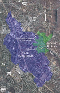
Tiber watershed. GIS data used to develop map obtained
from Howard County Government licensed under a Creative
Commons Attribution 4.0 International License.
The Storm
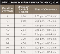
That Saturday evening in July had a typical Maryland summertime weather pattern of a warm day and isolated thunderstorms through the evening hours. Temperatures ranged in the mid-80s with light winds. Rain moved into the area just after 6 p.m., with the peak of the storms dropping 1.44 inches of rainfall in a 10-minute period just before 8 p.m. and just over 4.5 inches during the peak hour. The Baltimore-Washington International (KBWI) weather station, located less than 10 miles from Ellicott City, recorded 1.80 inches of rainfall on July 30 and about 1/2 inch of rainfall the two days prior.
According to the National Oceanic and Atmospheric Administration’s (NOAA’s) Atlas 14 Point Precipitation Frequency Estimates, the 1,000-year average recurrence interval, three-hour-duration storm event in this region of Maryland would produce 6.05 inches of rainfall. Shorter-duration periods throughout the storm based on NWS data also appear to exceed the 1,000-year average recurrence interval.
The Watershed
The Tiber River and its tributaries flow directly through and under the historic district of Ellicott City and contain an estimated 3.7 square miles of the contributing area, which drains directly into the Patapsco River immediately downstream of the city and eventually to the Chesapeake Bay. With a mix of residential development, highways, and wooded areas, the watershed is not unlike much of the typical Baltimore-Washington suburban regions with a typical distribution of impervious to pervious ratio.
Main Street in Ellicott City resides within the 100-year FEMA floodplain, and, unfortunately, flooding in the area is not unusual. Flooding seems to occur about every five to 15 years, based on records dating back to 1817. Much of the flooding occurs simultaneously with flooding along the Patapsco River. Most noteworthy events seem to coincide with hurricanes and tropical storm remnants that have passed through the Mid-Atlantic region of the United States. An existing study, completed 2014, indicates the 100-year flood would flow at a depth of 1 to 2 feet with other isolated areas exceeding 3 feet of flow depth along Main Street. The report considers what types of stormwater management and storm conveyance improvements could benefit the watershed, conveying runoff with less hazard to the public and existing infrastructure.
The conclusions indicate that quantity management, the attenuation of runoff through stormwater management facilities, would have the most favorable results but would not totally relieve the Main Street corridor of flooding. Improvements in storm drain conduits did show improvements but negligible changes in flow depths.
Small Pond Analysis
Designers and engineers routinely consider storm events up to the 100-year flood but rarely are required to consider more substantial events. Land development and improvements to existing sites generally require stormwater management controls, which include quantity management and water-quality treatment. These controls are typically focused most on the 10-year, 24-hour-duration storm event, which has a 10% chance of occurring in any given year. In most cases, this is the normal requirement; however, in areas of known flooding, including the Tiber watershed, quantity attenuation of the 100-year, 24-hour-duration storm is required. Management of the 100-year storm requires developers not to increase runoff conditions from predevelopment hydrology calculations. This theoretically reduces flooding by managing peak rates of runoff from development sites by storing the water within stormwater management facilities and controlling the release rate downstream. While the release of stored runoff will maintain a consistent rate over a longer period of time than the natural storm event, the peak flow is significantly reduced from non-attenuated flows.
It is important to note that stormwater management design is largely based on assumptions. By this, I mean that civil engineers design to a standard and not to a specific storm event. Rainfall is unpredictable, and no two storm events are the same. Watersheds change throughout the year with the seasons, and these conditions would change runoff characteristics even if a storm were to repeat itself. The goal of any design is to meet the standards and requirements set forth by jurisdictional regulations, so design practices are consistent throughout a region no matter who the engineer or designer is. These standards allow us to compare constructed facilities with design plans for consistency and compliance with specifications. All in all, this is a good practice; however, it does not necessarily model exactly how a specific storm event will act in real-world circumstances.
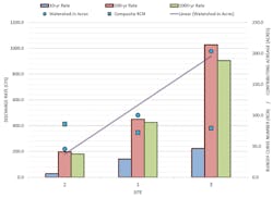
That said, utilizing the rainfall distribution and data obtained from the National Weather Service from the Ellicott City storm, we used the Natural Resources Conservation Service (NRCS) winTR-20, a commonly accepted design software for hydrograph comparisons, to look at three different stormwater management facilities to see how they would handle a similar event falling within their specific watershed in the design setting. Results of the simulated Ellicott City storm were compared to both the 10-year and 100-year 24-hour design storm events.
Typical stormwater management design criteria for central Maryland require quantity management for the 10-year, 24-hour-duration storm event to “predeveloped” condition. This typically provides attenuation of the increased runoff resulting from land development. Facilities meeting certain criteria including the height of dam and storage volumes are required to meet different levels of safe conveyance and freeboard criteria. Our primary focus of the analysis was to consider facilities that met NRCS Maryland Conservation Standard Practices for Ponds (Code 378), which defines construction standards and specifications and ultimately serves as a guide for dam hazard classifications.
The three facilities studied are typical of development in the region with varying contributing watersheds and design features. These facilities were chosen because the primary goal of the study was to find out how this specific rare high-intensity, short-term storm event affects the normal site development stormwater management facility.
Receiving approximately 100 acres of runoff from a residential subdivision, Site 1 consists of half-acre lots, along with a network of community roadways. The initial 2 inches of runoff, the water-quality 1-year storm event, is conveyed through a surface sand filter and drains by way of an underdrain into a riser-barrel assembly. A weir notch in the face of the riser provides attenuation control of the 10-year storm event, while the open top riser is designed to convey the 100-year storm event with adequate freeboard.
Site 2 has a contributing watershed of about 45 acres of commercial and industrial property. Flow is conveyed by a storm drain into the facility, which uses a surface sand filter to treat the first 2.5 inches of runoff. The storage volume of the facility is sized to manage the 10-year storm event and safely convey higher storm peak flows by discharging flow through an earthen emergency spillway.
Roughly 200 acres of urban runoff is guided by culvert into Site 3. A large majority of the watershed is residential, including single-family homes, duplexes, and townhomes along with apartment complexes and condominiums. Other areas include commercial and small industrial businesses along with a network of roadways and alleys. The facility provides water quality through a permanent wet pool and discharges regulated storm flow through a concrete multistage weir wall.
Each of these facilities is designed to manage a 4.69-inch, 10-year, 24-hour storm event to “predeveloped” (meadow/woods) conditions and safely convey storms up to and including the 8.06-inch, 100-year, 24-hour storm event with at least 1 foot of design freeboard. In the design scenarios, each was analyzed utilizing a standard Type II rainfall distribution in winTR-20 to evaluate and determine peak discharge rates and attenuation depths within the facility. The study incorporated the 6.6-inch, 1,000-year, three-hour storm that struck Ellicott City.
Small Pond Results
I hypothesized that the 1,000-year storm event would exceed the intensity of the 100-year storm event, resulting in higher inflow rates into the stormwater management facilities and potentially endangering the dam with an overtopping situation if the outlet assembly could not meet the discharge demands.
Surprisingly, in all three cases, the Ellicott City 1,000-year, three-hour event essentially matched the 100-year, 24-hour event. While this is a small sample of facilities, it shows with consistency that while the intensity exceeds that of the 100-year design storm, the overall conveyance and storage depths nearly match the longer-duration 100-year design event. Obviously, this does not constitute what will happen in every scenario; however, it does show that a design focused on safely conveying the 100-year, 24-hour-duration event through the facility will in fact with some confidence safely convey some rare, high-intensity storm events.
This initial finding seems to be consistent with the 2014 Ellicott City flood study that indicated 100-year flood depths along Main Street to be 1 to 2 feet. If in fact the 1,000-year, three-hour event would materialize with a similar peak rate to the 100-year, 24-hour-duration event, storm flow depths through the city would inherently be similar. Based on available photographs and videos from various news outlets, these flow depths seem to be relatively consistent.
Small-scale stormwater management practices, micro-practices, were not considered as a part of this study but are typically not designed to convey the 100-year storm event. These often consider the 10-year storm, but not always. Treatment facilities such as these, usually focused on water quality, should be designed to essentially fail during rare high-intensity storms and ensuing floods. When possible, they should be designed offline to minimize the damage by redirecting peak flow rates past the treatment practice. Where small embankments are used, designers should consider the impacts to downstream infrastructure, especially inlets and small culverts, when sediment-laden runoff is conveyed through the waterways after they wash out. Albeit less than ideal during normal conditions, micro-practices situated in excavations could be designed to allow additional ponding of runoff to occur during these rare events. This may cause additional areas to be inundated by water but could actually benefit the overall discharge conditions by attenuating extra runoff and thus reducing peak flow rates.
Car located in Patapsco River
Moving Forward
This scenario will not always be the case. Where downstream flooding is a serious concern, designers and approval authorities should take necessary precautions and considerations throughout the design and review process. Engineers are constantly forced to evaluate various scenarios while regulators and approval authorities must make informed decisions for the well-being of the public and environment.
Rare storm events, happening only once or twice in a five- to 10-year span, can be devastating both to the physical region and to the local economy. Ellicott City’s business district was closed for weeks following the flash flood because of the damage and destruction of the infrastructure. Business owners and homeowners were forced from their establishments while 24-hour security watched over the area, restricting access and deterring burglaries and vandals. A firm number is not available at the time of this article, but costs resulting from the flood are listed in the millions. From infrastructure reconstruction to loss of business, damages to inventory, and restricted access to the region, some totals simply cannot be measured.
Using this information, we realize that some rare storm events, while extraordinary in themselves, do not necessarily exceed the normal stormwater management design parameters. With this in mind, how can we as engineers and designers take steps toward improving public safety while maintaining reasonable costs to construct infrastructure as part of the development process?
For site development facilities, especially those that are required to receive a hazard classification, analyzing brim-up storm events may be one option. A brim-up storm event is the design scenario that maximizes the hydraulic ability of the facility’s outlet structure to be exceeded and allows runoff to overtop the dam. In design theory, this event would cause the dam’s failure by overtopping. Through a dam breach analysis, the resulting effect and inundation area can be considered on the downstream waterway. If the anticipated impacts do not appear to require anything other than a low-hazard dam classification, we can assume that even if a rare event caused the failure of a dam, the resulting flow could be conveyed reasonably safely through the receiving waterway.
Grading of development sites can consider what will happen if inlets and other storm drain conduits are inundated and flow is directed through surface routes. To minimize flooding in areas where people may be, surface flow should be directed away from doors and buildings even when all subsurface drainage is blocked.
It is unrealistic to design storm drain infrastructure to safely convey rare storm events that may never occur. The cost for this infrastructure would be astronomical; however, when site conditions permit, an engineer should consider the value of increasing segments of infrastructure. Although not intending to overdesign systems, adding unnecessary cost to the developer, minor design changes such as increasing pipe slope or upsizing pipe segments to provide better design flows can be beneficial to safely conveying occasional high-rate flows.
One could argue that stormwater management facilities with a 25- to 50-year service life should not be required to design for a storm event that has a 1-in-100 probability of recurrence, yet historically these atypical storm events seem to occur more frequently, and losing key design mechanisms including ponds would be devastating to watershed stability. Experience has proven that adding a minimal cost in stormwater drainage design stages greatly reduces repair costs; after all, this is the concept behind value engineering. Value is derived from comparing function to cost and thus value engineering must improve function or reduce cost; a balance of each will lead to a successful design.
Conclusion
In coordination with state and federal regulations, stormwater management and drainage principles and practices continue to evolve. This evolution includes advanced treatment methods for improving water quality along with the goal of reducing runoff during storm events. It is unrealistic to believe that one analysis or design practice would provide an exact prediction of a rare event.
With a better understanding of unusual and infrequent storms, additional case study information, and a compassion for both human life and environmental impacts, I believe we will only get better at predicting and designing to reduce flash flooding events. Nevertheless, nature is powerful and relentless. No design is perfect, and no matter how unlikely a storm is, it is impossible to design and construct infrastructure to safely convey all storm event runoff safely.
