When Mother Nature decided enough was enough and signaled an end to the last Ice Age, the huge glacier blanketing what is now Ontario, Canada, with ice nearly 4 1/2 miles thick, began to melt. As the ice retreated to the north it left deep depressions in the land, which began to fill with water from the melting ice, forming the five lakes we know as Superior, Michigan, Huron, Erie, and Ontario.
Considered youngsters at only 10,000 years of age, the Great Lakes continued their formative stage as the land shifted and tilted from the receding glacier. As the water traveled eastward, emptying into the Niagara River creating the spectacular Niagara Falls, a new drainage pattern emerged, creating the St Lawrence River. Ojibwa Indian legend describes five Indian girls arrayed in colorful dress who bravely jumped the waters as responsible for imparting the colorful “rainbow” seen at the Niagara Falls.
Steeped in history and legend of both the Unites States and Canada, the Great Lakes have played a significant role in commerce, in recreation, as a source of fish, and as a source of drinking water for more than 45 millions residents of the Great Lakes basin. Moreover, their complex ecosystems support numerous wildlife and plant species. Unfortunately, we have not always been the best of stewards for these national treasures, and the delicate balance of the lakes has suffered. By 2010, however, the largest investment in the Great Lakes in decades was underway, and the results of the Great Lakes Restoration Initiative (GLRI) are already promising a healthy future to the world’s largest freshwater surface.
Tired of Being Ignored
When it comes to restoration of our water resources, Norm Grannemann, regional director of the Midwest Region of the US Geological Survey (USGS) and interagency task force member of the GLRI, says other areas had historically been the focus of attention from federal and state authorities. He cites successful lobbying efforts as key in directing funding to the restoration of the Everglades, Puget Sound, Chesapeake Bay, and San Francisco Bay ecosystems, but attention toward the Great Lakes was lukewarm. And he wanted that to change.
“We said, “˜Look, we are the largest freshwater system in the entire world, with a very large ecosystem. Why are we not equally eligible for restoration funding monies?'” he says.
The evolution of the GLRI finally began in 2004, with an Executive Order signed by then-President Bush, who created the Great Lakes Regional Collaboration. This program launched the efforts of more than 1,500 individuals, who were charged with formulating a massive fact-finding document identifying the problems, corrective strategies, and dollars needed for the five Great Lakes.
“Our $20 billion budget was an ambitious target goal,” says Grannemann, but beyond achieving the dollar figure there was another very sticky problem. “This region includes several states and another country, which adds a very complicated financial and political dilemma to the equation,” he says.
In 2009, the Obama Administration authorized funding, with the limitation that monies would be used for ecosystems and not for building the infrastructure improvements, such as new stormwater sewer systems, as proposed in the original document. Congress then created the GLRI, allocating a far smaller $475 million in funding, which Grannemann says, with reallocations, “funds the project at about $2.5 billion for a five-year period.”
Making a Difference With Collaboration
While the GLRI is headquartered under the umbrella of the Department of the Interior (DOI), the operations are spread among an interagency task force with regional members from the DOI’s Bureau of Indian Affairs (BIA), Fish and Wildlife Services (FWS), National Park Service (NPS), USGS, and the Office of Environmental Policy and Compliance (OEPC).
They all have different missions and bring their unique experiences to the table from other projects on fisheries, erosion, and water quality, thereby enhancing the coordinated efforts of the GLRI mission.
“The Great Lakes Restoration Initiative is about collaboration,” says Midwest Deputy Regional Director Charlie Wooley of the FWS. “The US Fish and Wildlife Service is proud to work with our federal, state, and NGO [nongovernmental organization] partners to make the Great Lakes cleaner and healthier. There’s a lot of work to be done, but by working together we are making a difference.”
Kaitlin Steiger-Meister, Ph.D., also from that agency, explains that the GRLI has four focal areas: Toxic Substances and Areas of Concern (AOCs), Invasive Species, Habitat and Wildlife, and Accountability. These areas are addressed by different partner agencies at the state and federal levels.
“Over the years agencies have picked topics within four focal areas to highlight.” For example, she explains, “The EPA has focused on phosphorous loading being one (tied to AOCs), and Asian carp falls under Invasive Species. As another example, piping plover and lake sturgeon work are commonly highlighted under Habitat and Wildlife Protection.”
When individual state agencies get involved, the positive outcomes of the GRLI mission can literally be appreciated right in your own backyard.

Ron Osting drives the tree planter, and Gary places the seedlings in the slit; the packer wheels then compress around the seedlings.
A Success Story Down on the Farm
At the state capital in Columbus, OH, soil scientist and resource conservationist Danielle Balduff, Ph.D., notes the Natural Resources Conservation Services (NRCS) is a component department of the US Department of Agriculture (USDA), another partnering agency, and while Lake Erie is not in the immediate vista of the Columbus state office tower, it is nonetheless very much on the horizon of the NRCS.
Balduff, who is in charge of the NRCS magnet floodplain and wetlands reserve program, says, “We are provided funding through the GLRI to offer grants to help Ohio residents obtain emergency watershed conservation funding through the NRCS easement program.”
Congress first established the Emergency Watershed Protection Program (EWP) to help people conserve and recover from natural disasters such as floods, fires, drought, and windstorms. The program, which also includes the EWP Floodplain Easement Program (FPE), is administered through the USDA and NRCS. Balduff says the easement program, which receives funding from the GLRI, helps protect lands in the designated Lake Erie floodplain.
Closer to the Lake Erie shoreline in northwest Ohio is regional NRCS wetland team leader Charlie Hanner, who says “anyone who owns land is eligible for the easement program.”
He says, “We work with all landowners, and our intention is to restore the floodplain back to its natural habitat.”
One of the recent success stories is the reforestation of property owned by the Osting farm family, who applied for the Ohio floodplain easement program and were selected to receive NRCS funds.

Selecting trees for the Osting Farm reforestation and easement project
According to Hanner, the Ostings, of northwest Ohio, had retired from raising champion 4-H cattle and were getting tired of floodwaters from the stream on their farm practically coming in the back door. They spoke of the problems from annual flooding, such as lost crops and even livestock being swept away. The stream on their property in Putnam County feeds into the Auglaize River, a 113-mile-long tributary of the Maumee River–tagged as one of the worst eutrophication sources leading directly to Lake Erie. Sensitive to the threat of erosion and the importance of keeping soil and maintaining a habitat for wildlife, the Ostings were enthusiastic about the perpetual easement program to help restore their property.
“By putting in a permanent easement through the program, the landowner consents to our purchase rights contract, which grants the landowner right of title. And they can still own quiet enjoyment and control of access; they retain recreational use and any subsurface minerals,” explains Hanner. The permanent easement does restrict certain haying, mowing, cropping, and grazing, and “any alternations are also restricted, such as putting up a building or use for dumping.”
In return, the property owner is funded to restore the floodplain, which in this case was 9.5 acres of reforestation using native plantings.
Gary Steinbrunner, owner of Reforestation and Wildlife Services of Port Recovery, OH, was chosen for the job. He says his strong passion for wildlife and conservation got him involved with bringing back lands to natural habitat. When Hanner referred him to the Ostings, they had a short window of time to get the job done and Ron Osting helped prepare the land.
“We selected seedlings that included a variety of crabapple, black chokeberry, swamp white oak, bald cypress, black walnut, pin oak, and shellbark hickory, and, because they wanted some pines, we chose eastern white pine which are suitable to the soils on the site,” says Hanner.
But the easement is more involved than just hauling in a truckload of seedlings and hoping for the best.

Herbicide kills the potentially competing grasses in rows where trees will be planted.
Doing the Groundwork
“When they contacted me in the spring of 2013 and told me what the recommended plantings were, I said we have to hurry up and get the trees ordered,” says Steinbrunner.
Because the easement property was then in pasture, Steinbrunner says, “The first thing we had to do was spread herbicide, as the grasses will outcompete the new young trees for moisture.”
Before planting, a special tree planter traverses the property to break through the sod and create a slit.
“Then, the trees are put in the slit and packer wheels press against the ground,” explains Steinbrunner, emphasizing that disrupting the network of sod roots is crucial. “In sod, root zone is tight; when you get a July and August of hot, dry weather the slit can open up and dry out the tree roots, causing them to die.”

The Ostings consult with NRCS on their easement plan.
To reduce tree loss, Steinbrunner spread herbicide in strips for the trees and left a swath of grass between the tree zones to act as erosion control. Ten days after applying the herbicide, he says, they tilled the rows in 10-foot spacings, with 6 feet of grass left in between. By tearing up the sod, they would get good soil- to-root contact.
The tree roots, Steinbrunner says, are fairly short: “Most of the trees are 10 inches at the most; hickory can have a 12-inch taproot. But it’s important to get the soil loosened up deep enough to get good soil compaction around the roots.”
He notes, “The day we planted was a combination of weather, both snow and rain. There were cloudy skies and a lot of moisture in the air, perfect for tree planting.”
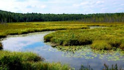
Lake ErieThe most biologically productive of the Great Lakes, Erie comprises three basins: the Western, which includes the islands; the Central, which extends from the islands to Erie, PA; and the Eastern, which extends to Buffalo in western New York. Lake Erie is also the warmest and shallowest of the Great Lakes, being only 210 feet at its deepest point in the Eastern basin; by contrast, Lake Superior’s deepest point is 1,335 feet.
The economic and social importance of Lake Erie to the region’s commercial and public communities is significant as well. It is known for sport fishery, with Lake Erie walleye considered a prized delicacy, and yellow perch and smallmouth bass in abundance and an easy catch. The lake’s 312-mile Ohio shoreline also offers year-round tourism and recreation opportunities, and when millions of northern Ohio residents turn on the faucet they are depending on a healthy lake to provide drinking water. Perhaps less well known is that the lake is a major mineral source; huge mountains of limestone and salt can be seen near the water’s edge from Cleveland’s Shoreway Drive. Finally, the lake provides a sense of history and identity for the region.
A Prognosis for Success
Steinbrunner has a two-year maintenance program with the Ostings, which is part of the easement statute to do onsite monitoring, and then will conduct one visitation every five years. The project reports that the trees are now thriving at about 80%, and a recommended March regimen of pre-measured herbicide is keeping the grasses from sprouting.
The trees and lower-growing shrubs serve both a water retention and an important wildlife purpose.
“As these get older,” he says, “especially the fruit trees and pine, [they] will provide a habitat for wildlife to roost or den under; keeping a good wildlife habitat was also important to the Osting family.”
With good response from landowners, Hanner says, there are 12 other easements in place, all in the counties of the northwest quadrant of Ohio that drain to Lake Erie. He’s optimistic about the program’s benefit to the watershed and the lake.
“We’re hoping, overall, that the floodplain will be used and filter nutrients before it [water] reaches groundwater,” he says. “This is nature’s mechanism for removing sediment and nutrients, these floodplains that will use and recycle the flood water and allow the natural floodplain to come into play.”
He notes that several programs exist, and the easement is just a small part of a greater set of funding in the Ohio area, such as the Environmental Incentive Program that helps farmers with conservation practices.
“Farmers can get nutrient management help to control runoff, which is a big problem here,” he adds. “With the help of GLRI we hope to put in conservation practices to prevent nutrients from making their way into Lake Erie.”

The original tee box at Lost Nation Golf Course
The Little Lighthouse That Could (Help Lake Erie)
While standing in line during the dreaded annual Bureau of Motor Vehicles (BMV) ritual, Ohio residents can directly benefit Lake Erie restoration efforts by the metal license plates they choose. But what they may not know is that they are also helping conserve the wetlands of their local golf course, control water at their favorite shopping mall, or just make a Sunday fishing outing more successful for the dinner table.
Gail Hesse, executive director of the Ohio Lake Erie Commission (OLEC), headquartered in the northwest Ohio shoreline city of Sandusky, describes how BMV customers help to fulfill OLEC’s mission.
“We are funded primarily by the sale of two Ohio license plates that feature the image of a Lake Erie sunset and the historic Marblehead Lighthouse,” she says.

Built in 1821, the lighthouse is the oldest continuously operating lighthouse on the Great Lakes. “The revenue generated from the license plate sales goes directly into the Lake Erie Protection Fund,” she notes.
These funds, held in OLEC’s oversight, allow the commission to award grants on a quarterly basis to academic institutions, municipalities, advocacy groups, and others whose projects are aligned with OLEC’s 12 priority areas in preserving and restoring Lake Erie and its resources and furthering its economic development.
The 12 priority areas are described in The Lake Erie Protection and Restoration Plan 2013, which Hesse helped prepare. They are nonpoint-source pollution, invasive species, coastal health, Great Lakes areas of concern (AOC), toxic pollutants, habitat and species, indicators and information, sustainable development, water withdrawals, climate change, jobs and the economy, and dredged sediment.

One of the responsibilities of OLEC is to further public awareness of these state strategies to keep Ohioans informed on current threats and mitigation strategies, and to highlight current objectives that will affect the comeback of the lake.
Small Scale for Big Results
Hesse says that although OLEC is “a small, standalone state government agency,” its real strength comes from the collaboration with six Ohio cabinet agencies, including the Departments of Natural Resources, Transportation, Agriculture, Development, and Development Services and the Environmental Protection Agency. Together they work to identify and implement programs that benefit water quality, habitat protection and restoration, recreation and tourism, and resource management in the Lake Erie basin.
“In the late ’70s Lake Erie was in terrible condition,” says Hesse, but legislation that controlled phosphorous from wastewater plants launched a recovery process. “We know from a resource standpoint, it [Lake Erie] is very quick to respond to environment changes, and we saw a rebound of the lake, which was pointed to as a best system recovery.”
However, there were new problems to face, she says, including “invasive species, changes in weather patterns, changes in the type of phosphorous, and significant algal blooms.”
Hesse cites the Maumee and Sandusky Rivers in northwest Ohio that empty in Lake Erie as the source of some of the worst phosphorous contamination in all of the Great Lakes.
“What gets delivered to Lake Erie by the Maumee and Sandusky is largely from agricultural use,” says Hesse. “But now we’re seeing a new, dissolved type of phosphorous, which means it is phosphorous in solution, making it 100% bioavailable for algal production, compared to previous years when phosphorous was 30% bioavailable coming from treatment plants.”
So although there is not more phosphorous going onto the fields in fertilizer, the farmers’ timing and placement of fertilizer in concert with weather conditions can wreak havoc. The “four Rs,” as Hesse calls them, make all the difference: right time, right rate, right source, right placement.
“If fertilizer is applied in winter, it is sitting on frozen ground; when rain falls on frozen ground it washes away.” And not all farmers are doing the same thing, as “what’s right” is going to vary for the three crops–corn, wheat, and soybeans–that dominate this local landscape.
Studies about the change in bioavailability point toward how the phosphorous is bound when it reaches the lake. With no-till farming practices, which farmers were urged to adopt to reduce soil losses, fertilizer tends to sit on the surface and can easily wash away in soluble form, making if far more bioavailable than if it were bound to soil particles. Although no-till is a recommended best management practice–it reduces erosion and sediment–it is actually contributing to algal bloom increases.
It’s All About Slowing It Down
“We are encouraging more riparian streamside vegetation and riparian wetland restoration and talking about slowing water down,” says Hesse. “There’s no single practice, and it takes varied efforts by many to pull together and meet the watershed challenges.”
Grants to organizations, institutions, and municipalities from the OLEC Lake Erie Protection Fund are often the first stepping stone to meeting those challenges.
Lost Nation Golf Course Sets New Boundaries
“Well, all you can see right now is straw,” says Mitch Allen, superintendent of the city of Willoughby, OH’s municipal golf course.
Located 25 miles east of Cleveland and just 2 miles south of the Lake Erie shoreline, Lost Nation Golf Course is one of Ohio’s oldest continuously operating public golf courses, named after a mysteriously abandoned Indian settlement.
“According to local Indian folklore, there was an Indian camp found completely abandoned at the end of the street here,” he says. “Speculation is that the people were Iroquois, and there may have been smallpox, or they just all up and left for no known reason, possibly going to Canada, but they were called the Lost Nation, and the name stuck.”
Allen describes how the city-owned course, in continuous operation since 1929, plays a role in preserving the Lake Erie watershed and how both players and the lake benefit from a recent Lake Erie Protection Fund grant award.

“We’re in a floodplain with Ward Creek, which goes through our course, then into the Chagrin River and into lake Erie; the water goes up and goes down very fast. This was undermining the bridge abutments on the course and starting to eat at the fairway areas by encroaching on some of the hillsides, where it was starting to be a danger to the golfers.”
He describes the genesis of the restoration project and how Lost Nation Golf Course became a focal point. Initially, the city’s parks director was approached by the Chagrin River Watershed Partners (CRWP). The not-for-profit organization helps cities, townships, and parks in northeast Ohio through grants and technical assistance. The CRWP had received funding from the Lake Erie Protection Fund and from federal agencies to address the Chagrin River watershed stormwater and erosion problems. Looking back, Allen says, the CRWP played a crucial role; he praises their “excellent communications that helped to keep the project moving forward.”

He says, “The city officials came to us and said “˜Here’s a grant opportunity for the city to do restoration on the Ward Creek through the Chagrin Rivers Watershed Partners.’ The officials were looking at three or four sites on the Chagrin River where they could apply for funding, and when they came down here the bells went off and they said a Lost Nation stream restoration would be a perfect opportunity.”
As a public venue, the golf course offered a very visible showcase for people to see a stream restoration in action, which only added to its appeal as a choice restoration site.
Aligning Goals, Ideas, and Perspectives for Best Outcomes
Next, a design-build contract was put out for bid by the city, and Davey Environmental Management was chosen to do the work. Allen was pleased that they engaged a golf course architect to help with the project, but the city and Allen each had their own perspectives on shaping the project.
“From my standpoint, I was looking at it as a golf course, and as erosion and aesthetics; everyone else was looking at it as a stormwater problem. Everyone had their own thoughts, and we tried to reach a happy medium in our corrective approach.”
Grading work began in September 2013 and continued into the first snow week of November. The work included redesigning some of the playing course. Allen says the challenge was to do the work and keep the course open during the process.
“We’re run by the city and attract 37,000 rounds of golf every year. I was happy we could keep the course open while we were doing the construction work, as to my knowledge this is the first time they’ve tried this on an active golf course. You could see work from the parking lot, and the players on course also got to see what we were doing.”
But as the course is a municipal property, he had to convince the public that it wasn’t costing them, or the city, anything to do the work.
“Our grants were a little over a quarter million dollars, and we only spent maybe $7,000 on moving some irrigation lines.”
Changing the Water Course, the Pace of Play
To address the erosion problems, the contractors put riffle structures in the stream and regraded some of the banks, installing bendway weirs, “so that we have positive water drainage,” says Allen.
“Then we created what I like to call waste areas, buffer zones along the edge of the stream. We now will have 40 feet of wide, low-growing plant materials, and where golfers used to be able to play up to the edge of the stream, now they will be back 40 feet.”
He says it will be interesting to see “when this grows in how it impacts the pace of play, looking for golf balls and so forth.”
The shrub species selected are native to the area, such as low-growing willow button bush and water-retaining resistant oak. However, because of the severe and lingering winter, planting was delayed until spring 2014.
On one of the holes, Allen says, a small wetland existed, and envisioning an opportunity, he chose to enhance the natural area with a significant expansion. However, this required a creative redesign of the entire hole play.
“We rerouted everything to create a larger wetlands and sited the tee box at the other hill. There’s a ton of deer, raccoons, a few wild turkeys, foxes, and coyotes,” says Allen, proud of the wildlife population for which he has been able to provide new habitat.
He is also hoping to get more fish and bird activity in the pools of the natural areas, “which adds to the aesthetics and makes the play more enjoyable.” Other plantings enhancing the site are yellow birch, white oak, and dogwood.
After being the in the golf business for more than 33 years, Allen says, he believes this restoration opportunity was just one of “those right things to do, finding the happy medium, accomplishing the goals to reduce sediment runoff and getting the main waterways in better shape. We’re doing our little part of that effort.”
The Great Lakes truly are great, and while it was a long time in coming, the interest in preserving, restoring, and enhancing their capacity as a precious water resource, important ecosystem, and economic contributor is now being recognized and expanding to bring these visions into reality.
Sources for More Information
http://healthylakes.org/wp-content/uploads/2013/06/Ohio-NRCS.pdf
http://graham.umich.edu/news/lake-erie-dead-zone
www.crwp.org
http://greatlakesrestoration.us
http://lakeerie.ohio.gov
www.crwp.org/index.php/projects/restoration-projects-current/newell-ward-creek-green-infrastructure