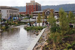
When people say the city of Yonkers, NY, is on the Saw Mill River, they mean that—literally. Downtown Yonkers is built on top of the swiftly flowing channel known as the Saw Mill River. From the cellars of some of the industrial-era buildings near the center of town, one can actually see the river flowing beneath the basements and across the gaps between the foundations of adjacent structures. Closer to the center of town, the river had once been channeled into a flume several blocks long, entirely hidden from view. But last winter that changed, and thanks to the efforts of a diverse group of advocates, engineers, and just plain citizens, the Saw Mill River was reborn.
City engineer Paul Summerfield says the daylighted Saw Mill can be seen as part of a movement among old school industrial cities to reinvent themselves as modern destinations.
It’s also the culmination of a lot of people’s dreams. And it’s a small but positive step toward revitalizing the ecology of the Hudson Valley.
A River Runs Under It
Originally known to Native American tribes of the region as the Nepperhan, or “rapid little water,” the Saw Mill River personifies the story of North American invention, ingenuity, and renewal. Brad Tito, sustainability manager for the city of Yonkers, says, “The Saw Mill River was really central to the development of the city in its early days, and it was a critical piece of infrastructure for the industrial development of the city.”
Early Dutch colonial settlers chose the location along the banks of the Hudson tributary nearly four hundred years ago to establish an industrial community. It was just a few miles north of New Amsterdam, a city we of course now know as New York. The mills got to work and a city grew up around them.
Industry quickly diversified, powered by the swift river and mills. Eventually, Yonkers supplied the critical piece of DNA that made New York City—just across the Hudson—the icon we know today. In 1853, not far from the banks of the Saw Mill, Elisha Otis cut the cable that secured his elevator car high above a spellbound audience, and survived, successfully demonstrating his new invention: the safety elevator. From the banks of the Saw Mill, Otis Elevator Company ushered in the age of the skyscraper, and the region rocketed upward.
In Yonkers, industry of all kinds, from elevators to floor coverings, climbed to new heights, and right along with it, so did pollution. By the early 20th century, the last mile of the Saw Mill River flowing through downtown was so fouled with debris from industrial and household waste that Summerfield says it could have been described as an open sewer.
City leaders decided the best solution was to simply cover it over, and by 1925 the Saw Mill River in downtown Yonkers had vanished from the landscape, encased in a half-mile-long, 10-foot by-20-foot steel and concrete flume, built by the US Army Corps of Engineers and carrying it right up to its confluence with the Hudson River.
Ann-Marie Mitroff, river programs director for Groundwork Hudson Valley, imagines there must have people who thought covering up the river was a crazy idea from the beginning, but eventually, it seems most everyone just forgot about it. And the Department of Motor Vehicles parking lot at Larkin Plaza that eventually came to mark the site became a well populated, if not much loved, destination for motorists from southern Westchester County.
But Mitroff says behind the scenes the river did have champions who wanted to bring it back, including the Hudson River Fishermen’s Association, the group that evolved into the influential advocacy group Riverkeeper. To top it off, the Army Corps of Engineers concluded after a 1998 study that the Saw Mill presented a fine candidate for major habitat restoration. Groundwork, in coordination with the Saw Mill River Coalition, stepped forward to begin coordinating concrete efforts to rescue the river from beneath the Larkin Plaza parking lot.
The Saw Mill River Coalition sponsored tours of the river’s underground tunnels and culverts for public officials and others, which it says helped win a $3.1 billion commitment from a local realty group, Struever-Fidelco-Capelli, to build housing and commercial development along the river.
Although the inspiration for restoring the Saw Mill may have had its roots in the distant past, the impetus for getting the project underway came in 2005 from New York Governor George Pataki, who advocated a $34 million plan for uncovering the river in his “State of the State” address.
An Odd Fish
In spite of the intense development along the riparian corridor, the Saw Mill maintained a softer, natural side and played host to one of the oddest fish stories in nature, the American eel migration.
The eel, which is now being considered for protection under the Endangered Species Act, is believed to be the only North American fish species that migrates out to sea to spawn and upstream through tiny channels into coldwater streams and creeks to mature. According to the US Fish and Wildlife Service, “even today, the American eel’s complex life history is not completely understood.”
What makes the eels’ journey up the Saw Mill even odder is the fact that they begin their trip, like many so commuters, at the rail station that sits just atop the confluence with the Hudson River. Mitroff says the eels, just a few inches in length in their immature transparent phase, struggle their way upriver through the basements of Yonkers’ warehouses and factories; through mill races, against the stream; and on to the culverts constructed by the Corps of Engineers to control flooding before finding their way to more natural channels upstream.
Some small fraction of the fry ultimately make their way to creeks, pools, and ponds inland, where they take several years to reach maturity, growing up to 5 feet in length before reversing the journey out to the tropical realm of the Sargasso Sea, to the northeast of the Bahamas, to spawn the next generation.
“They can crawl up anything,” says Mitroff. Seven and a half miles up river they make light work of scaling a 20-foot dam. “That’s how good they are,” she says. But Mitroff notes that with the improvements contemplated for the river, the real challenge would be getting the mature eels back out to sea. She says the planned netting system designed to remove unsightly floatables and trash from a newly daylighted river would “basically, kill them on the way back down,” because, at 3 feet long and 3 inches in diameter, the eels would not be able to escape from the nets.
A New Identity
When heavy industry began to decline in western economies, many cities scrambled to create a new identity for themselves by emphasizing the aesthetics rather than the utility of nearby water bodies.
For example, Summerfield says, his hometown of Birmingham, England, reconfigured and dressed out its old industrial canals to recall the allure of Venice, Italy, with considerable success.
“There is an area in the city center where the canals were basically abandoned,” he says. However, “with funding from the EU, the city renovated the canals to make them a real destination. They cleaned them up, created walkways on the side, put bridges over them, and encouraged developers to come in and start developing the area. Now that is a very booming area.” In addition, he says, Birmingham built a symphony hall nearby. “Private developers came in and built apartments, restaurants, and bars, and it’s now quite a destination.”
Several longitudes east, in one of the biggest projects of its kind, Seoul, South Korea, uncapped a stretch of river known as Cheonggye Stream, sections of which had been buried since the 1950s by a massive superhighway. That project transformed a congested stretch of freeway into a slice of tree-lined countryside in the city, resulting in an immensely popular urban amenity, attracting pedestrians and families to frolic in a once forbidden zone.
Closer to home, a Providence, RI, daylighting project at the confluence of the Woonasquatucket and Moshassuck Rivers at the Providence River turned a formerly neglected waterway, enshrouded in several acres of concrete roadway interchanges known as “the widest bridge in the world,” into a genuine attraction. Upon its transformation into Providence’s Waterplace development, the site quickly became a popular destination and now hosts a world-famous annual riverfront arts celebration called WaterFire and other cultural events.
“I can see a similar thing happening here; we’ve been doing a lot along the Hudson River waterfront,” says Summerfield. Although the loss of commerce certainly hurt, when industry began to fade fromthe Hudson Valley, he says, water quality improved over time, presenting an opportunity to see the river as a focal point for recreation and economic stimulus for the redevelopment of the downtown area in specialties other than manufacturing.
Imagining the Invisible
Mitroff says the goal of the Saw Mill daylighting project was not to restore the river to its original course, or to simply set it free, but to introduce natural habitat to the city center and create a downtown destination that revolved around the vitality of that habitat.
But, she says, “The thing for people to know is that visualizing things is a critical piece for any kind of restoration, whether ecological or environmental. Lots of things move quickly because people get some visual sense of how it might be. So we did some early conceptual drawings, and we enlisted Columbia design students and other people. That really carried the day; people could actually start talking about it then.”
Mitroff says that early on, Groundwork hosted a series of community charrettes to bring neighbors and residents into the planning process for the Saw Mill project.
“A lot of people would have thought, “˜Oh gosh, we’re going to have all these rabble-rousers,’ because we invited people to the table who are not necessarily happy with the city, or who don’t think they do a good job. But I think by the time everybody gets out of the process, they understand how incredibly complex it is and how many audiences need to be served.” Furthermore, she says once a community begins to understand “the various constraints, not just budgetary, but also the physical constraints of a site, the better the plan comes out at the end.”
She adds, “It gives the developer or designer a good framework without guessing about stuff.”
Andrew Grundy, project manager for Paulus, Sokolowski & Sartor LLC (PS&S), the engineering design firm that handled the project, agrees. “We did a lot of work with the community before we got started,” he says. “When the community does the process first, you’re not doing a lot of concept drawing and sketches and going back and forth. We have a list up front of what they want and don’t want. If you do that up front, the city doesn’t have to hold meetings where the community comes out and says, “˜Hold on. Wait a minute, what’s going on here?’ It’s already agreed.”
“If you have the amount of time—a year in advance—to start doing this on a project before a city goes out to bid on the actual design work, then you bring that to the table for the design firm so they understand it, you get a much better park,” says Mitroff.
Along with the daylighted Saw Mill River, plans for the Park at Larkin Plaza include a 1,000-seat amphitheater where, Mitroff says, the public can enjoy music or poetry or presentations. In addition, she says the park will have some quiet areas where “you can just be by yourself and have a cup of coffee.”
Putting a River Back on Track
With a history of industrial use dating back more than 300 years at the site, Grundy says, there was a lot going on underground. “We dealt with a lot of utilities in the ground–water, sewer, drainage, gas, old abandoned utilities.”
He says, “It was half known and mapped, and half of it wasn’t. One of the benefits we did have was good as-built info for what was done in 1925, but the stuff after that was less well documented.” The project required a lot of test excavation with the utilities to determine where lines were actually located and to avoid, or address, potential conflicts.
“You always expect some conflicts when you’re doing subsurface work; we had many meetings with Con Edison, Cablevision, and others to go over conflicts,” he says.
The daylighting project also gave the city a chance to deal with a few of its longstanding combined sewer overflow issues, Summerfield says.
“There were a couple of places where there were some overflows from our combined sewers directly into the river. We disconnected those and removed the storm drainage that was going into the combined sewers, and now it’s directed into the river. We have a couple of water-quality basins that somewhat clean the water.”
But the core of the project was to give the river back to the community.
The plan however, was not to dismantle the flume in an attempt to return the river to its predevelopment state. “To deconstruct this thing would take millions of dollars,” says Mitroff. In fact, she says, the flume itself follows a different path from the original river, which she speculates has been adjusted for various purposes several times over the centuries. “I mean, we have manipulated this river to death,” she says.
“There was no real reason to keep the riverbed where the flume was,” she notes, and ultimately engineers reached a decision: “It was actually better to keep the flume in place for flood mitigation and build a new and better habitat for a new river right next to it,” explains Mitroff. And that’s the course the project took.
Summerfield elaborates: “Basically, what we’ve done is we’ve left the flume in place to carry the excess stormflows when you get a big rainstorm. We’ve built an intercept chamber at the top end of the flume near Warburton Avenue. That intercept chamber is about 20 feet down, and ties into the upstream end of the river. It diverts a controlled amount of the flow into the now-daylighted portion of the river, so you have two sections of the river that are basically running parallel.
“We had a specialty company come in with a wire cutter, and they cut the sections of the flume, like slicing a cake. Sections of that flume are about 3 feet thick.” To create the intercept and confluence chambers at the two ends of the park, Summerfield says, “They sliced through this, into about four-foot segments, and moved it away with a crane to break it up.”
The two parallel river courses meet up again in the confluence chamber the project constructed just south of the park, with the combined flow then entering the Hudson below the Buena Vista Avenue train station.
Summerfield says that at the outset there was some concern about where DMV customers would find parking once the project got underway. But something surprising happened that seemed to ease even that situation. “I noticed that when we took the parking away, the streets in the surrounding neighborhoods started to become busier, and you started to get more foot traffic.” As motorists spread out looking for parking, Summerfield says, even before the park was complete, “The look of Main Street and some of the other streets improved just because you had more people down there. There was more activity.”
Nonetheless, he says the city has plans for a new parking structure “just a couple of blocks” from the new park to accommodate visitors and commerce attracted by the new ambience.
Happy Fish
In moving the riverbed back to the surface, Yonkers recreated 13,775 square feet of aquatic habitat, including a tidal pool and two freshwater pools. Summerfield says one of the water features at the downstream end is a “stepped weir in six steps, each about 10 inches high, providing a change in water elevation.”
He notes, “That’s a challenge for the eels to get up, so we designed a fish passage, which is an aluminum trough next to this step-down weir with a number of vanes to provide aeration for the water. It allows the eels to bypass these steps and to get up into the next part of the river.”
To figure out a way to get the adult eels back down, Groundwork, with support from the city, brought in a fisheries engineer from the New Hampshire firm Lakeside Engineering, who, Mitroff says, configured “a very unique, slick, and simple design” that provides for an opening in the netting chamber 2 feet wide by 4 inches high that she says will protect that migration.
“If we had not done the public process piece of it, that probably never would have happened,” adds Mitroff.
The project final plan also called for recreating the natural features of a coastal river, complete with tidal pools, freshwater pools, riffles, and falls. Rocks were used to create embankment overhangs and provide snags for cover, while plentiful submerged aquatic vegetation will provide nursery habitat and aquatic insect habitat. Plans also call for fish ladders with options for trapping devices to conduct monitoring and scientific research.
Summerfield contrasts the look and feel of the new Saw Mill with that of other urban river restoration projects, such as the one in his hometown of Birmingham, or in San Antonio, TX, which he says replicate a sedate Venetian canal motif.
“Here, there is a real river that we’ve created–with different features. The water is calm when it comes out of the flume. Then it drops a little, and then runs over the riffles and over a waterfall.
“When there’s a storm, you get variations in the flow, so you get different conditions in the river. Anybody that comes by there is really very impressed with what’s going on–it’s a terrific project,” says Summerfield.
Bridging the Future
Mitroff says the daylighting project has helped highlight the importance of taking a watershed perspective for ecological restoration projects. She says a big part of the ongoing effort will be keeping the upper watershed communities informed about the project and conveying the message “that what’s really important to us down here is the amount of trash that comes down.”
She notes, “These communities are for the first time in a long time working together on those kinds of issues. I think the daylighting is exciting to people, and they understand more of how it is connected to the upper watershed.”
Mitroff says that Groundwork has plans to use EPA Targeted Watershed funding to sponsor a tour of the watershed for the planning boards, municipal staff, and officials from the entire watershed “to really get the full view of how everybody impacts everybody else. We want to end up at the new park with a reception,” says Mitroff.
At a December 2011 ceremony marking the completion of the $19 million project’s first phase, Yonkers Mayor Philip Amicone, speaking at the new park, termed it an historic occasion. “Today we officially give the Saw Mill River—the river this city was literally built around—back to the people of Yonkers,” he says. In testament to the popularity of the effort, a few weeks later the city’s incoming mayor, Mike Spano, paid homage to the Saw Mill daylighting project in his own inaugural address.
With the heavy lifting completed, and with the Saw Mill River’s base flows diverted to flow through the 800-foot-long newly daylighted channel, Grundy says the river is looking better already. “It’s a benefit to the community. You’re taking a parking lot and turning it into a park. Most of the time when you are developing, you’re taking natural landscape and paving it—adding impervious areas.
“Our office is right next door, we’ve got the water flowing, it’s really nice—a really cool project,” he says. “We’re trying very hard to make sure everyone has a piece in what happens there through the programming for the arts, for community organizations, public markets, all kinds of things that everybody can enjoy.”
It’s really pitched at being a community park as well as being a showcase for daylighting.
Tito, the city’s sustainability manager, says, “I honestly don’t think a lot of people were aware that there was a river under the parking lot.
“Yonkers is really a vibrant, transit-oriented community. We have an exciting mix downtown of business, residences, pedestrian facilities, access to mass transit all on the waterfront of the Hudson River—and to add to that acres of new open space in the public realm, and you have a city that all Yonkers residents can be proud of. This is about laying the groundwork for Yonkers to be a model for the sustainable cities of the future.”
And, thinking of the development he expects the project to attract, he adds, “Who wouldn’t want an office overlooking a beautifully restored open space with water flowing through downtown? We expect this to even be a tourist attraction to some extent. It’s very easy top jump on a train and be in Yonkers in twenty minutes just to have lunch in the Larkin Plaza Park.”


