Restoring water quality in impaired watersheds requires understanding the complex interactions of hydrology, climate, and land use. Pollution transport from diffuse sources is most often driven by meteorological events (i.e., precipitation), which is highly correlated to pollutant loadings (e.g., sediment) from a given watershed (Novotny and Olem 1994). The Environmental Protection Agency’s Wadeable Streams Assessment, a biological assessment of 1,392 randomly selected wadeable stream sites in the conterminous US, indicates that 42% of the nation’s wadeable stream length is in poor biological condition relative to reference site conditions (USEPA 2006). One of the greatest water-quality constituents causing impairment is suspended sediment. This is of importance given that the physical quality of stream water is greatly affected by the amount of sediments present. In the state of Missouri alone, more than 150 water bodies have been identified as impaired or limited for a variety of beneficial uses since 2000. This figure is 15% higher than the national average of 25% freshwater impairment in a given state. This is particularly important considering that Missouri is one of nine central US states that contribute more than 75% of upland nitrogen and phosphorus to the Gulf of Mexico, US (Alexander et al. 2008).
The relationships between land use and sediment transport are not well understood. Hydrologic modification exacted by development can increase or decrease (to varying degrees) diffuse pollution loads and particle class concentrations. There is a need to quantify the pollutant transporting mechanism(s) and consider the various pathways contaminants may travel from variable source areas (VSAs) to receiving water bodies. For example, in terms of primary VSAs, larger particle size classes may originate primarily from localized riparian development and instream hydrogeomorphological processes (i.e., bank erosion, channel incision), while smaller particle size class concentrations may increase in urban environments that tend to preferentially collect and transport smaller particle size classes. Regardless of the mechanism, there is little argument that freshwater resources are increasingly threatened by sedimentation caused by upland soil and streambank erosion, agriculture, and rapidly spreading urbanization. In general, suspended sediment originating from overland sources enters a stream system and either remains suspended, thus being rapidly transported from the watershed, or settles out of suspension, having exceeded the transport capacity of the stream (Figure 1). If the latter, sediment may be deposited in the streambed, or as alluvium, where it remains until it is mobilized during a storm event of sufficient volume. This process may be repeated until the sediment is either transported from the watershed or removed from the stream system by other means (e.g., gravel extraction). Research is needed to better understand the mechanistic relationships between development, storm duration and magnitude, and sediment particle class concentrations.
While excessively high sediment loads detrimentally impact stream ecosystem health and water quality, stream sediment processes are a naturally occurring and necessary process in stream ecosystems. Too little sediment could be as damaging to stream geomorphologic and ecological functions as too much. Streams deprived of sediments can lead to increased channel erosion, habitat degradation, nutrient depletion, and significantly altered biological health (e.g., fish populations). For example, increases in light penetration due to low turbidity can reduce primary productivity, thus breaking down the stream ecosystem food web, and give nonnative, sight-feeding fish competitive advantages (Kondolf 1997). Sediment provides a valuable nutrient source to support invertebrate populations (Dodds and Whiles 2004, Koirala 2009). However, too much fine sediment can fill interstitial spaces of gravel in spawning beds, reduce available oxygen needed by fish embryos, and can cause gill inflammation and eventual death to young and susceptible fish (Kondolf 1997). Clearly, there is a need to better understand natural and anthropogenic sediment loading processes with particular focus on fine particle class separations, since smaller sediments migrating from urban landscapes may exacerbate these impacts.
Unlike many other water-quality constituents of concern, identification of sediment-impaired watercourses is complicated, because sediment in streams and rivers has both natural and anthropogenic sources. Consequently, quantifying the level of impairment and thus the efficacy of best management practices is confounded by a lack of understanding of background (i.e., pre-settlement) sediment loads. In most urban stream systems, land-use changes in the watershed over time have dramatically altered the hydrology and sediment loading to the system. Urban systems are often the least resilient to additional perturbation due to compounded effects of development including (but not limited to) increased imperviousness, removal of vegetated canopies, and natural depressions, which are graded to a uniform slope. Following construction, impervious surfaces impede infiltration and most rainfall becomes runoff. Natural drainage systems become rapidly overwhelmed, incising the stream channel, eroding banks, and increasing downstream discharge. Effects to water quality are often first observed in altered sediment loading regimes.
Turbidity measurements are the most common means for determining suspended sediment concentration (SSC) (Pruitt 2003). However, accuracy can be much improved by conducting gravimetric analyses of water samples collected manually or by automatic water samplers (Edwards and Glysson 1999, Davis 2005). Gravimetric methods involve filtering the sediment from a known sample volume using a vacuum filtration process (ASTM 2007). Using a series of different-sized filters, information about particle size distribution of the sample can be obtained. However, sample collection and laboratory analyses using these methods tend to be prohibitively expensive, difficult, and labor intensive and prone to human error (Gray and Gartner 2009).
Sediment Laser Diffraction
Recent innovations in suspended sediment monitoring include fully automated in-situ devices that continuously sense and log suspended sediment and particle size classes. Commercially available instruments include those that use bulk optics, acoustics, pressure differentials, and laser optics. Bulk optics instruments measure the turbidity of the water, where turbidity is an expression of the optical properties of the water that cause light to be scattered and absorbed rather than transmitted directly through solution (Gray and Gartner 2009). Other instruments currently used to quantify SSC include acoustic backscattering technology, portable acoustic Doppler current profilers (ADCPs) (Gray and Gartner 2009), and laser diffraction analyzers (Agrawal and Pottsmith 2000).
Laser diffraction (LD) instruments measure optical scattering of light over a wide range of angles, providing a multiparameter measurement corresponding to a wide range of particle sizes (Agrawal and Pottsmith 2000). Laser diffraction instruments use specially constructed detectors to detect light-scattering effects of particles of individual particle classes. The total volume of particles provides the information necessary to estimate total concentration independent of particle density or size distribution. Laser diffraction instruments also estimate the mean particle size by computing the ratio of total particle area to total particle volume. Notably, many LD instruments estimate a volumetric concentration (i.e., µl/l) of sediment as opposed to a mass concentration (Agrawal and Pottsmith 2000), thus requiring estimates of particle density to make the mass conversion (i.e. mg/l).
Particle Size Class Detection: The LISST-StreamSide
One of the most recent LD instruments available on the market is manufactured by Sequoia Scientific Inc. Laser in-situ scattering and transmissometry (LISST) instruments were originally developed for marine sediment studies, but the technology has evolved for deployment in freshwater systems. The LISST-StreamSide is designed for monitoring sediment in shallow rivers, streams, and ponds (Figure 2). A pump is placed in the water body to pump water to the particle analyzer for analysis. After analysis, the water sample is returned to the source, thus eliminating handling and lab processing of the sample. The LISST-StreamSide senses particle sizes ranging from 1.9 to 387 µm (note: 1 µm = 3.95 x 10⁻⁵ inch). Validation studies of the LISST indicate that the LISST is able to estimate particle class density with an accuracy of 10% to 20%, with greater accuracy for smaller particle classes (Agrawal and Pottsmith 2000, Gartner et al. 2001). The dynamic range of the LISST is 1:200. Therefore, the largest size that can be measured is 200 times the smallest size. This range is spread out over 32 detectors (i.e., size classes). Particle size class detector rings are logarithmically spaced such that each upper size bin is 1.18 times the lower size. For example, the ring that represents 5 µm covers a range of 4.7 to 5.54 µm, while with larger particles, the ring that represents 200 µm covers a range of 179.2 to 211.5 µm. Therefore, the ring that detects larger particle size has a much broader sensitivity range as compared to smaller size classes, thus reducing resolution and accuracy (Gartner et al. 2001). There are many reasons for this configuration, including design considerations to maximize the number of individual size classes while minimizing error. One result is higher accuracy at smaller size classes and reduced resolution of larger particle size classes. Sensor validation for smaller size classes and densities is beyond the scope of the current work, but supplies impetus for current ongoing work in the Interdisciplinary Hydrology Laboratory of the University of Missouri, http://web.missouri.edu/~hubbartj.
The following case study was undertaken to quantify particle distribution and loading during a typical spring rainfall event in an Ozark border stream of central Missouri. The LISST-StreamSide provides high-resolution SSC and particle size distribution (PSD) data that traditional methods of sediment sampling are not capable of achieving. Therefore, results were expected to provide never-before-quantified relationships between rainfall, runoff, and particle size class concentrations in a central Missouri urban watershed. It is worthy of mention that methods and information generated from this work is widely adaptable to other regions.Case Study: The Hinkson Creek Watershed
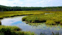
The Hinkson Creek watershed (HCW) is located within the Lower Missouri-Moreau River Basin (LMMRB) in central Missouri (Figure 3). The HCW was instrumented with a nested-scale experimental watershed study design (Figure 2) in the fall of 2008 to study contemporary land use and urbanization effects on hydrologic processes, water quality, and localized effects on climate and biological community health. Nested watershed study designs use a series of sub-basins inside a larger watershed to examine environmental variables. Sub-basins are often determined based on dominant land use and characteristics of the hydrologic system (Capel et al. 2008). A nested watershed study design enables researchers to quantifiably ascertain the influencing patterns and processes observed at each location (Pickett et al. 1997, Hubbart et al. 2007, Karwan et al. 2007). Each of five fully automated gauging station monitors stage and a complete suite of climate variables. Instrumentation in the HCW is complimented by a United States Geological Survey gauging station (USGS-06910230) that has collected data intermittently since 1966 (Figure 3, site 4). The Missouri Department of Natural Resources (MDNR) targeted a portion of the LMMRB as critical for controlling erosion and nonpoint source pollution in 1998 (MDNR 2006). Watershed restoration efforts in the LMMRB were accelerated by mandates of the Clean Water Act (CWA) and subsequent lawsuits. Hinkson Creek watershed is representative of the LMMRB with respect to hydrologic processes, water quality, climate, and land use and was one of the first water bodies in Missouri to be placed on the CWA 303(d) list.
Hinkson Creek flows through a catchment basin of approximately 81.2 square miles (231 square kilometers). The creek flows approximately 26 miles (42 kilometers) in a southwesterly direction to Perche Creek, ultimately flowing into the Missouri River. Elevation ranges from 580 feet (177 meters) at the confluence of Perche Creek to 890 feet (274 meters) above mean sea level in the headwaters. Hinkson Creek is classified as a Missouri Ozark border stream located in the transitional zone between Glaciated Plains and Ozark Natural Divisions (Thom and Wilson 1980). Average annual temperature and precipitation are approximately 57ºF (14ºC) and 38 inches (980 mm), respectively. Soil types range from loamy till with a well-developed clay pan in the uplands (Chapman et al. 2002) to thin cherty clay and silty to sandy clay in lower reaches. Urban areas are primarily residential (approximately 90,000 residents) with progressive commercial expansion. Land use in the watershed is approximately 34% forest, 38% pasture or cropland, and 25% urban area; the remaining land area is wetland, open, or shrub/grassland areas.
Site 4 is the location of the LISST used in the current study.
LISST Deployment
A LISST-StreamSide was deployed at site 4 (Figures 2 and 3) in the HCW during the on March 27 through March 31, 2010, to analyze water samples during a typical spring rainfall event. Water samples were run through the LISST on an hourly basis. Sampling protocols are easily programmed through a graphics touch display on the LISST. Primary protocols include a presampling background check, which allows for automatic calibration of the instrument using deionized or other clean water sources, and sampling duration. For the current work, 60-second sample durations (approximately 1.1 liters or 0.3 gallons) were used to optimize sampling accuracy. Precipitation and flow was measured at the site 4 climate station and USGS stage monitoring site. The total contributing area draining to site 4 (LISST location) is 180 square kilometers (69.5 square miles). Land use draining to site 4 is dominated by pasture and cropland comprising 44% of the land area, followed by 36% forests and 16% urban, with the remaining being evenly distributed between shrub/grassland and wetlands or open water. Local area surrounding site 4 is primarily low-intensity development.
Results and Discussion
Weather over the period of study (March 27–31, 2010) was typical for the central Missouri wet season during the month of March (Figure 4). Average temperature and average stream flow were 12.8°C (55°F) and 2.4 m3/s (84 f3/s) respectively, during the four-day period of study. Average pre- and post-storm flow was 1.4 m3/s (51 f3/s) and 2.9 m3/s (102 f3/s) respectively. On March 28, a 13.2 mm (0.52 in.) precipitation event occurred. Resultant peak flow was 7.0 m3/s (247 f3/s). Total concentration of suspended sediment during pre- and post-event conditions was approximately 29 and 75 µl/l, respectively. Average PSC was 142 and 116 µm during pre- and post-event conditions, respectively. Notably, total SSC was approximately three times higher post-event, while average particle size was almost 20% lower in post-event, higher-flow conditions.
Therefore, while total concentrations were higher in post-event flow recessions, the ratio of smaller size classes to larger size class particles decreased such that total suspend sediment had a higher composition of finer particles. This previously unknown information may be attributable to naturally occurring or anthropogenic effects, the elucidation of which is beyond the scope of the current analysis and requires evaluation of longer time-series data. Figure 4 shows selected particle class concentrations during the period of study. As expected, there is a dramatic increase of all PSCs shown with increased flow
(Figure 5); however, the concentrations of finer particles are quantifiably higher relative to larger particle classes. The relative ratios of larger to smaller size class concentrations have not been previously quantified.
Figures 6 and 7 illustrate pre- and post-storm event particle class concentrations. Figure 6 reflects a cube-root transform of the data for improved visual inspection of the concentration differences (normal log 10 distributions are nested in red). A 13.2-mm (0.52-in.) rainfall event resulted in greatly increased particle concentrations, especially in the smaller size classes during this event. Figure 7 further illustrates this finding listing the relative percent of total concentration for each size class.
The largest particle class (356.79 µm) comprised almost 50% of the total concentration of suspended sediments in the pre-event flow condition, whereas in the post-precipitation flow event condition it comprised nearly 44%, a 12.5% difference (Figure 8). The smallest particle class (2.06 µm) concentrations in pre and post-precipitation event conditions was 0.8 and 3.4%, respectively, reflecting a more than 450% difference in post-flow conditions after only a 13.2-mm (0.52-in.) precipitation event! This finding is remarkable given that the 13.2-mm (0.52-in.) precipitation event doubled the amount of flow from 1.4 m3/s (51 f3/s) to 2.9 m3/s (102 f3/s), but more than quadrupled the concentrations of finer particles of sediment. While this trend may seem unsurprising to some, the ability to quantify the differences is novel, and the potential to use this type of information to better understand the effects of land use, and in particular urban land use, will supply never-before-available information to land managers wishing to mitigate proportionally increased fine sediments emanating from urban developments that might not otherwise be transported to the stream channel in forested and/or agricultural lands.
It is interesting to note that in post-precipitation event runoff conditions, particle classes 94.34 through 155.36 µm decreased. This could be explained in part by LISST accuracy limitations and/or doubling of volume and thus a volume-based reduction of sediment size class by dilution. It may also be that at these concentrations the high silt and clay composition may lead to flocculation of particles and thus higher estimated concentrations such as those in the 17- to 57-µm size classes. Elucidating these differences necessitates study replication, much longer data time series, plus quantifiable characterization of soil class separations in the central region of the US. While these questions are beyond the scope of the current analysis, it provides impetus for ongoing work in the watershed.
Figure 8. Percent change in particle class concentrations pre- and post-rainfall in the HCW
Confounding factors when working with the LISST-StreamSide include supplying power at remote locations, and obtaining proper enclosures in the field that not only supply dry conditions but also remain close enough to the water source to pump water to the LISST. In the HCW, safe locations for instrumentation are as far as 37 meters (120 feet) from the stream to avoid flooding. Mitigating these complications may require multiple solar panels, batteries, and different pump and hose configurations. A basic assumption of LISST onboard computations is that particles are homogeneous spheres. This may not hold true in soils that are composed of silt and clay composition, and are thus, on average, not spherical. Further, while the LISST-StreamSide measures particle sizes between 2.5 and 500 µm (Agrawal and Pottsmith 2000), smaller particles (i.e., <2.5 µm) may aggregate in to flocs and thus produce a signal in larger PSCs, thus skewing results. Similarly, larger particle classes may be lightweight flocs or biological material. Further, during high flows it is possible to get larger particles in suspension, but during slow flows the larger particles may not be grains of sand. Finally, while volumetric estimates of sediment concentrations are useful, volumetric indices are not the conventional unit for presenting sediment concentrations. In general, lacking in other information, the conversion from µl/l to mg/l is often conducted assuming a particle density of 2.65 g/cm3 (i.e., the density of silica). However, it is probable that mass concentration calculated assuming density of silica will not correlate well to traditional gravimetric estimations. It is therefore advisable to calibrate LD technology with gravimetric methods. Gravimetric calculations of sediment were not conducted in the current work. However, estimating particle densities for each of the 32 size classes of the LISST is the objective of future work. In spite of complications, proper field configurations can generate data that have the potential to improve the mechanistic understanding of suspended sediment concentrations and yield in freshwater supplies. LISST technology may therefore advance the current level of understanding of suspended sediment and particle size concentrations across a wide variety of land-use types and climate events and thus improve the current state of understanding and therefore management of freshwater resources.
Conclusions
Information stemming from this case study represents the first information of this type from a dynamic urbanizing watershed in the Central US. Watershed studies, such as the HCW, utilizing established study design protocols (i.e., nested-scale design) will provide new information to stormwater managers wishing to make science-based decisions to meet water-quality standards. This work showed that a 13.2-mm (0.52-in.) rainfall event resulted in a doubling of streamflow (1.4 m3/s (51 f3/s) to 2.9 m3/s (102 f3/s) but resulted in more than doubling the concentration of particle size classes ranging from 0.2 to 67.65 µm. This result illustrates the need to better understand fine particle suspended sediment concentrations in stormwater runoff from urbanizing systems relative to that flowing from agricultural and/or forest environments. Continued work may therefore hold important implications for understanding the effects of urbanization on sediment loading, instream biota, and sustainable water quality and water resource-related commodities. The LISST-StreamSide holds great promise for helping to achieve these ideals, but validation using gravimetric methods is strongly advised.
In watersheds the size of Hinkson Creek, comprehensive management approaches that examine not only the volume of water causing impairments and the variable use landscape, but also the pollution load being transported, are imperative. In the HCW and other similarly affected watersheds across America, the work presented here is timely given legal mandates to provide quantifiable estimates of total maximum daily loads (TMDLs). Given the relative size of the HCW and the scope of land uses in the watershed, the HCW serves as common ground encouraging cooperation, trust, and innovation between watershed stakeholders to reach a common goal to improve and sustain water quality, and as a model urban watershed for similar studies.