Water Quality Study Focuses on Central Idaho Mining Area
The U.S. Geological Survey (USGS) published results of a three-year water-quality study in the Stibnite Mining District of central Idaho. Midas Gold and the Idaho Department of Lands commissioned the study. This unbiased and impartial study may be used as Midas Gold considers future mining operations in the area that was once a source of gold, antimony, mercury and tungsten.
The USGS collected water samples between 2012 and 2014 from a network of five monitoring sites along the East Fork of the South Fork of the Salmon River (EFSFSR) and two tributaries, Meadow Creek, and Sugar Creek. Analyses of those water samples showed that concentrations of arsenic exceeded human health-based water quality criteria at all but one site. That site, on Meadow Creek, was selected to represent background conditions. Similarly, concentrations of antimony exceeded human health-based water-quality criteria at the three sites farthest downstream in the study area.
Mercury concentrations exceeded Idaho ambient water-quality criteria at all five sites. However, nearly all of the mercury flowing out of the study area can be attributed to Sugar Creek, the site farthest downstream. The Sugar Creek watershed contains the former Cinnabar mercury mine.
USGS hydrologist Alexandra Etheridge used the water-quality sampling results to develop regression models that quantified the amounts of arsenic and antimony being contributed to specific reaches of the EFSFSR. The models indicate that groundwater may be contributing substantial amounts of arsenic and antimony to the streams.
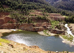
“This study shows for the first time that Meadow Creek upstream of the confluence with EFSFSR is not the only substantial source of arsenic and antimony in the study area,” Etheridge said. “It also shows that the old mining pit on the EFSFSR known as the Glory Hole acts as a sediment trap, especially at high flow.”
In the coming weeks, Etheridge will work with USGS colleagues to provide model results on the USGS National Real-Time Water Quality website. Resource managers and the public will be able to use the website to estimate concentrations of arsenic and antimony at three monitoring sites in real time.
“The Stibnite Mining District has been impacted by a century of mining activity,” said Bob Barnes, chief operating officer of Midas Gold. “The possibility of re-mining and reclaiming the site using modern methods give us a unique opportunity to address this environmental legacy and restore the site. Midas Gold appreciates the efforts of the USGS in helping to further our understanding of baseline conditions and to plan for the future.”
Source: USGS
