A practical guide to building your stormwater management system
The increasing frequency and severity of extreme weather events have pushed stormwater management to the forefront of municipal concerns. Yet many smaller communities find themselves at a loss for where to begin. While sophisticated digital solutions promise streamlined operations, the foundation of effective stormwater management lies in methodical, ground-level data collection and organization. The first step in building a robust system is collecting good data.
The data foundation
The journey to effective stormwater management begins with a fundamental question: What data do you already have? Organizations must take stock of their existing resources before investing in expensive new systems or sensors. The cornerstone of this inventory often lies in topographic maps, which are readily available and can be purchased if needed. These maps serve as the canvas where you will paint a picture of your watershed system.
The first task is to mark out the streams, rivers, and known flooding areas using topographic and elevation maps. The elevation data prove invaluable in delineating runoff areas for the watershed. During this initial mapping phase, it is crucial to mark problem areas — these will become focal points for more detailed investigation later.
Leveraging available resources
There is no need to reinvent the wheel. The National Weather Service (NWS) maintains extensive storm data that can be accessed freely. The National Oceanic and Atmospheric Association (NOAA) and the U.S. Geological Survey (USGS) also publish valuable data online and are often willing to provide additional information when contacted directly. These public services represent a treasure trove of historical and current data that can jumpstart your management efforts.
Historical flooding data often exists in unexpected places. Long-time employees and residents can often provide invaluable insights about flooding events and problem areas that might not be captured in official records. This institutional and community knowledge should be documented and integrated into data collection efforts.
The field work imperative
While existing data provides a starting point, there is no substitute for boots-on-the-ground fieldwork. A well-equipped field kit should include:
- Boots and weather-appropriate gear
- Tape measures
- Surveyor’s rod
- Scrap wood for markers
- Depth gauges
- Spray paint or landscaper’s paint for marking reference points
The core of field data collection centers on measuring stream cross-sections, starting at road crossings and measuring not just the stream width but the full overbank-to-overbank distance. Additional cross-sections should be taken at points of interest such as resident complaints of washouts, and regular flooding areas. Stream curves require particular attention, with measurements taken upstream, at the curve and downstream.
Building the complete picture
Stream depth measurements must be correlated with cross-sections and seasonal variations. It is essential to note whether current conditions represent normal levels or reflect drought/flood situations. Water sampling adds another valuable layer, providing insights into both water sources and quality concerns.
Infrastructure documentation forms another critical component. Every culvert, weir, dam and pond structure must be measured and assessed. These control structures play vital roles in floodplain management and prevention. Understanding their conditions and interactions helps identify optimal locations for future sensor placement.
The value of collected data multiplies when properly organized. Each control structure and point of interest should receive a unique identifier, allowing for easy reference and correlation. Well-organized data enables comparison with historical data, revealing changes and trends over time. This compiled and correlated dataset forms the foundation of a watershed management system.
Leveraging technology for stormwater management
Once the foundational data is in place, the real excitement begins with integrating modern digital systems. This technological evolution goes beyond basic data storage, enabling communities to streamline operations, predict challenges, and respond proactively to emerging threats.
Modern stormwater management platforms offer a suite of powerful capabilities that extend far beyond basic data storage. Software solutions like Aquarius, employed by major organizations including USGS and Geological Survey of Canada (GSC), demonstrate the transformative potential of these systems. These platforms can:
- Automatically import and integrate data from sensors and external databases
- Calculate derived data in real-time
- Run sophisticated rating curves
- Compute aggregates instantly
- Fill data gaps seamlessly
- Build complex multi-input time series models
By automating data integration and analysis, they provide operators with a continuous stream of central intelligence without requiring manual input. This automation not only increases efficiency but also significantly reduces the risk of human error in data management.
Visual intelligence and real-time monitoring
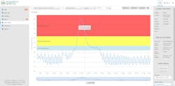
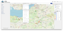
Modern dashboards and map-based interfaces make it easier to interact with stormwater data. These visualization tools can provide interactive displays of current conditions while enabling real-time monitoring of water levels across the entire system. By incorporating historical data overlay capabilities, operators can quickly identify patterns and trends that might otherwise go unnoticed. The systems excel at predictive modeling, offering intuitive interfaces that make complex data accessible and actionable. For example, operators can instantly overlay real-time water levels with historical flooding information, providing crucial context for decision-making during extreme weather events. Water quality conditions can be automatically compared against known standards, triggering alerts when parameters exceed acceptable ranges, and enabling swift response to emerging issues.
Stakeholder engagement and public communication
Modern systems have changed how organizations engage with their communities and stakeholders. Public-facing dashboards now provide transparency, giving residents direct access to real-time data about their local water systems. When flooding risks arise, automated alert systems can warn affected residents, while integrated communication systems help coordinate emergency response efforts. These platforms also streamline regulatory compliance through automated reporting tools, while maintaining comprehensive historical data archives that enhance legal defensibility. This level of transparency and communication helps build public trust and understanding of stormwater management efforts, leading to more informed and engaged communities.
Advanced analytics and prediction
Advanced multi-input time series models can now accurately predict flooding risks by analyzing multiple data streams simultaneously, while automated quality control systems continuously monitor for data anomalies that might indicate emerging problems. When gaps in data collection occur, intelligent algorithms ensure continuity by populating with the most likely values. Rating curve analysis has been improved through automation, providing better flow predictions and enabling more accurate modeling of system behavior. Most importantly, real-time aggregation capabilities enable operators to respond rapidly to changing conditions, transforming vast amounts of raw data into actionable insights within seconds. This combination of advanced analytics and real-time processing has fundamentally changed how organizations approach stormwater management, enabling proactive rather than reactive responses to developing situations.
Looking forward
As weather patterns become more extreme and unpredictable, the importance of robust stormwater management systems only grows. While modern technology offers powerful tools for optimization, success depends on the quality of your foundational data. By following a methodical approach to data collection and organization, while strategically implementing digital solutions, organizations can build systems capable of meeting current and future challenges.
About the Author
Symone Kumar
Symone Kumar is a product manager at Aquatic Informatics, where she leads the development of AQUARIUS software solutions for environmental data management. With extensive experience in water data systems, she specializes in helping organizations streamline their water quality monitoring through digital transformation.


