About the author:
Suzie Housley is product owner and lead scientist for StormSensor. Housley can be reached at [email protected].
by Suzie Housley
undefinedCoastal communities can no longer afford to manage storm water and sea level rise as separate issues. Sea levels are rising and all that extra water is starting to live rent-free within coastal storm water systems. These communities have anecdotally known this was possible for some time now, especially during king tides, but new data is revealing the extent of the issue.
Storm water systems are designed to move storm water off streets and other impervious surfaces into local waters in order to reduce flood risks. With the increasing frequency and intensity of storm events, performance of storm water infrastructure is key. However, as sea levels rise, the pipes that storm water is supposed to flow out of are increasingly being filled with seawater that is pushing inland. This can make it impossible for storm water to escape and lead to increased flooding. As climate change progresses, this situation is not only limited to regions directly at an outfall or to extreme high tide events. In some regions, this is happening all day, every day.
So, what does this mean for storm water management? It means that coastal communities do not have the level of protection from flooding that they think they do. Storm water and flood plain managers often assume they have the entire capacity of their storm water system available to convey runoff. These systems are, for the most part, buried underground and unmonitored. Without data to challenge standing assumptions, limited carrying capacities within the system due to sea level rise often go unaccounted for during regional planning, which can be a costly mistake. In a situation like this, even projects technically built to code can end up contributing to flooding because the risk from sea level rise was not addressed.
StormSensor has worked with several coastal communities interested in becoming more resilient to climate change. A first step in this process is determining impacts from sea level rise on their storm water systems.
A Different Approach: Monitoring as a BMP
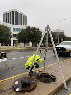
Traditional monitoring approaches often lean on small networks of sensors to evaluate best management practice (BMP) performance or to represent a region as a whole. These methods rely a lot on data extrapolation. StormSensor’s approach involves installing dense monitoring networks within a community’s storm water system. These networks consist of Scute sensors that track water temperature, depth and velocity every five minutes. Terrapin cloud-based software then receives real-time data from the Scutes and performs additional analytics. Terrapin also allows users to opt in to several data-driven, real-time alerts. With this level of data granularity and the ability to identify events as they occur, the monitoring network is elevated from a BMP evaluation tool to a BMP in its own right.
Coastal Monitoring Systems
One advantage of real-time monitoring networks is that because data is continually being updated, communities can utilize the network for multiple use cases, regardless of the initial intent of the installation. For example, when Jersey City, New Jersey, began monitoring its storm water and combined systems in the fall of 2019, officials were primarily interested in detecting CSO events, however, system-wide monitoring has incidentally revealed sea level rise-related impacts that would have otherwise gone unnoticed.
Norfolk, Virginia, began monitoring in summer 2020. This monitoring system was set up specifically to quantify the impacts of sea level rise to the storm water system in a flood-prone region of the city. Residents in the area had often mentioned that the area could not handle a “single drop” of rain without flooding.
North Miami began monitoring in winter 2021 and, like Norfolk, did so with a goal of determining sea level rise-related impacts to its storm water system, which it has long suspected are increasing in severity. Local urban legends claim that sea water intrusion led to a manatee lurking in the storm water system; the creature even got a shout-out in their regional storm water plan.
Data Reveals Impacts from Sea Level Rise
A similarity among the three coastal regions studied was a limited available capacity of the storm water system due to sea level rise. Taking a look at the diminished capacity of the storm water system specifically when it is not raining is a good way to get an idea of the system-wide impacts related to other sources. The systems within each city area were, on average, 16 to 45% full of water when it was not raining; meaning they are operating at just 54 to 83% of the planned capacity of the system.
Evidence was clear that these diminished capacities can be attributed, at least in part, to sea level rise in all three cities due to the observed diurnal pattern of flow within each system. One of the most striking findings to-date was the detection of a diurnal, tidal flow pattern at a monitoring point more than a mile inland in Norfolk.
The range of diminished capacity varied considerably across each region. Factors such as distance to the coast, elevation and presence of tidal controls all play a factor in the impacts to each storm water system.
In general, lower-lying regions tend to see more impacts from rising sea levels regardless of distance from the shore. For example, in Norfolk, the storm water system along a lower-lying segment saw impacts over a mile inland, while a nearby branch of the system at a higher elevation only saw impacts at points within 1,000 ft of the outfall. Impacts in North Miami were mostly tied to a tidal canal that eventually drains to Biscayne Bay. Both Norfolk and North Miami have inland monitoring points that tend towards 90% full at all times. This may be due to a “cove” effect, where tidal waters pushing inland cause a backup and make it impossible for the system to ever completely flush. Jersey City has installed tide gates at most outfalls, so impacts to their inland system were notably more limited but not completely eliminated. At that location, monitoring points in lower lying regions were 20 to 40% full during non-storm events, as opposed to 90 to 100% full in Norfolk and North Miami, demonstrating the effects of installing such controls.
From Data to Action
Though these communities cannot make major adjustments to their storm water infrastructure immediately, having this real-time data available has aided with day-to-day management. System managers no longer assume that the entire capacity of the storm water system is available, even in more inland areas. They are also able to utilize data-driven email and text notifications to tackle proactive maintenance in a more informed manner. For example, if a portion of the system has a diminished capacity and a large storm is approaching, they can send vac trucks to those priority locations instead of relying on a rigid schedule that does not take real-time conditions into account. They can also cite pumps and other short-term mitigation strategies along those priority regions.
Tracking this data is also helpful for long-term resiliency planning. Models in these regions will be validated using observed flow rates and storage capacities. Knowledge of diminished storage within the existing system due to sea level rise can be used to plan larger-scale storage projects, as well as to site and size future tide gates and other barriers.
While demonstrating that a storm water system is highly impacted by sea level rise is not the most desirable revelation, it is true that knowledge is power. Data has helped to shine a light on an often-overlooked segment of urban infrastructure, thus empowering these communities to move forward towards resiliency, knowing that they have a full understanding of the challenge they are up against.


