Harnessing data: the future of stormwater management
In an era of increasing urbanization and climate uncertainty, stormwater management faces unprecedented challenges. Leveraging the latest in data-driven technology, stormwater professionals can now turn the tide on flooding and pollution with precision and foresight.
Minimize failure risks with real-time data integration
Having the latest data on hand to characterize the condition of stormwater conveyance networks allows identification of vulnerable areas and potential flooding hotspots. Integrating Geographic Information Systems (GIS) data on stormwater infrastructure, such as pipes, channels, culverts and outfalls, with data from field crew operations can provide critical status updates. Recent inspections and maintenance data can provide alerts for potential conveyance and treatment network failure points in near real time. These insights translate to reducing the risks associated with the failure of stormwater conveyance and treatment.
For example, knowing the locations of inlets and catch basins that sporadically clog up can prompt the dispatch of maintenance crews to those areas before storms. Likewise, having the data to quantify the likelihood of infrastructure failure based on age, material or inspections can inform the need for pre-emptive actions to shore up weak points. These insights depend on having the technical capability to rapidly turn field observations into actionable intelligence. That means adopting mobile apps for field data collection, a GIS-based platform as a central data hub, and cloud data storage so that outputs can be accessed wherever they are needed.
How Salinas is leading the way in digital stormwater management
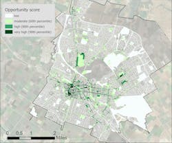
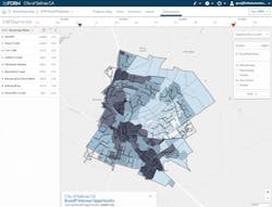
The City of Salinas in Central California is rapidly moving towards fully digitized stormwater asset management. A GIS-based data system is used to prioritize future investments and quantify stormwater benefits to support their Stormwater Master Plan. Connecting investments to outcomes helps stormwater program staff communicate the value of their program to the city leadership and the community. It also helps them quantify the gap between current funding and future levels of stormwater service required in the context of anticipated development and projected climate changes.
Maximize return on infrastructure investments with data-driven decisions
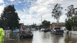
Urban landscapes are ever-changing, and the data used to make decisions should reflect those changes. The consequences of stormwater infrastructure failures are not equal everywhere in a city. A pipe failure during an intense rainstorm in a downtown center can damage storefronts and cause major traffic disruptions, whereas impacts may be lower in less densely populated areas. Current geographic data on impervious coverage, runoff generation, pipe routing, and hydraulics enables stormwater managers to make informed decisions about critical infrastructure investments. Limited resources can be allocated where they will help avoid the greatest failure costs. Insights that reflect the current state of infrastructure can contribute to stormwater master planning, informing replacements and upgrades over time.
Having a good handle on critical infrastructure needs is also a key step to position for procuring additional resources for capital improvements. As stormwater infrastructure needs are made clear to Congress1 and federal funding sources come online, new opportunities are appearing on the horizon. Being competitive will mean building the capacity to quantify and clearly communicate infrastructure needs, costs and likely consequences of inaction.
Future-proof your stormwater system
Stormwater programs cannot plan for the future by looking only to the past - they must adapt strategies to the changing climate conditions ahead. As cities face more intense rainstorms and more severe droughts, choices about which stormwater management practices to implement and where will need to account for shifting rainfall patterns. Modern stormwater simulation can readily include climate projections, downscaled to fit municipal needs2. These model outputs facilitate adaptive planning and provide vital inputs for designing climate resilient conveyance and treatment systems.
For example, in cities where a greater proportion of rainfall is being delivered in shorter bursts, distributed infiltration-based practices can attenuate peak flows downstream and restore hydrologic functioning of drainages3. This helps alleviate pressure on the conveyance network and reduces the entrainment and transport of pollutants to waterways. Additional adaptive benefits, such as CO2 uptake, habitat creation, urban cooling, and social well-being associated with green stormwater practices, can also be incorporated into stormwater planning within the context of projected climate changes.
Discover new opportunities with advanced simulation
Simulation models are used to predict stormwater behavior under various scenarios to inform flood protection, watershed-scale planning, and infrastructure design. They can also help identify opportunities for stormwater infiltration, treatment, and capture. Combining well-tested modeling approaches with cloud-based processing generates some truly impressive outputs. It is now possible to produce high resolution (30m) stormwater runoff predictions for entire cities, watersheds, and regions. For example, in partnership with 2NDNATURE, the Pacific Institute quantified the stormwater runoff capture potential in urbanized areas across the entire United States4. The resulting estimates can be quickly updated to reflect the growth of cities and shifting rainfall patterns. Such tools remove many of the barriers to accessing model outputs for non-expert users. They can also help facilitate a shift of perspective to view stormwater not just as a problem, but also as a valuable resource for augmenting municipal water supplies.
Chattanooga's seamless integration of stormwater data systems
The City of Chattanooga illustrates a successful stormwater data system adoption to support regulatory reporting required under their MS4 NPDES permit. With the adoption of several interconnected cloud-based stormwater data management modules, they now have a single data source to draw from for meeting their minimum control measure reporting requirements. These data reflect updates to locations, attributes or actions associated with each reporting element. The investment in technology pays dividends in the time it saves for collating annual reporting data every year.
Streamline regulatory compliance reporting
A readily updatable stormwater data system can make regulatory compliance reporting quicker and less painful for permittees. Maintaining up-to-date data on maintenance activities, post-construction requirements, inspections and monitoring helps cities meet local water quality standards efficiently, avoiding the stress of a last-minute reporting scramble. The key is connecting these datasets under a common geospatial framework. This avoids much of the work associated with collation, synthesis, and reporting of the same types of data each year. Adopting a continually updated system of record and connecting it to a GIS makes the process more efficient and less error prone.
Ready to revolutionize stormwater management?
Transforming a stormwater program to continually rely on the latest and greatest data is a marathon, not a sprint. Everyone starts at a different level of data readiness and technology adoption. Like preparing for a marathon, the starting point matters much less than deciding to begin the training. Here are a few simple tips that can help any program get going:
Dive into your stormwater data
Data gaps create barriers to progress. Do you know where all your control measures are located? How about data from field crews? Control measure and maintenance tracking data that are siloed off from other stormwater program data are less useful for prioritizing actions.
Evaluate your current technical level
There are likely more efficient and accurate ways to capture, store and analyze your data. An honest assessment of current technical capabilities and where they fall short of generating useful insights is a good place to start.
Learn from others further along the path
While every stormwater program is different, many lessons are transferable. Engaging at conferences, workshops and webinars are good ways to learn about how the technologies used by other programs are evolving and pitfalls to avoid.
Start simply
A full digital information overhaul can feel daunting. Start by identifying a type of data that would improve a specific decision or task. Is the problem that the data are not captured, or is there a technical barrier preventing access or interpretation?
Conclusion
Embracing data-driven strategies and modern technologies is not just a trend — it is a necessity for future-ready stormwater management. The use of GIS-centered tools that run in the cloud and can be rapidly updated through mobile apps are the way to ensure that planning aligns with on-the-ground priorities. By investing in these tools, communities can reduce risks, optimize resources, communicate the value of investments and play a central role in building more climate resilient communities across the US.
References
- Schlaudt, E., and J. Klein. "The Clean Watersheds Needs Survey and Stormwater Needs." In Stormwater Summitt 2021. Water Environment Federation, 2021.
- Nodine, Tyler G., Gary Conley, Catherine A. Riihimaki, Craig Holland, and Nicole G. Beck. "Modeling the impact of future rainfall changes on the effectiveness of urban stormwater control measures." Scientific Reports14, no. 1 (2024): 4082.
- Conley, Gary, Robert I. McDonald, Tyler Nodine, Teresa Chapman, Craig Holland, Christopher Hawkins, and Nicole Beck. "Assessing the influence of urban greenness and green stormwater infrastructure on hydrology from satellite remote sensing." Science of the Total Environment817 (2022): 152723.
- Berhanu, Bruk, Morgan Shimabuku, Shannon Spurlock, Jessica Dery, Heather Cooley, Catherine Riihimaki, Nicole Beck, and Gary Conley. 2024. “Untapped Potential: An Assessment of Urban Stormwater Runoff Potential in the United States” Oakland, Calif.: Pacific Institute.
About the Author

Gary Conley
Gary Conley is Chief Scientist at 2NDNATURE and has spent the last 20 years tackling water pollution problems. He leads scientific development of software tools that turn streams of data into actionable knowledge, improve watershed stewardship, and reduce the cost of clean water for cities across the US.


