A Model Solution
The city of Redlands, Calif., has a long history of flooding during moderate to severe storm events. The historic downtown area resides just downstream of the confluence of four major tributaries. The four tributaries run into a single storm drain under Redlands Boulevard, which routes flows through the downtown. The existing capacity of the current facility is approximately 2,000 cu ft per second (cfs). The 100-year peak flows tributary to it are in excess of 6,000 cfs. During large storm events, the downtown area has seen flood depths in excess of 4 ft. Dense urbanization and historical landmarks have restricted the potential options to alleviate the flood problem.
Over the last four decades, several agencies have studied this area in hopes of finding a solution. Most of the studies focused on one particular tributary, the Mill Creek Zanja, as the main culprit in causing the flooding. Many of these studies identified the solution of “bypassing” the Mill Creek Zanja flows around the main portion of downtown. This solution gained so much popularity over the years that 100% design plans were prepared and an easement was allocated for its construction.
The city of Redlands hired RBF Consulting, a company of Michael Baker Intl. (RBF/Baker), to prepare a storm drain Master Plan of Drainage. Included in this effort was an attempt to identify a potential solution to the regional flooding problem.
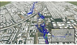
To understand the problem and to identify the causes, RBF/Baker prepared a coupled 1-D/2-D model using XPSWMM. The surface 2-D model covered approximately 1.4 sq miles of rural and urban downtown area. A detailed topographic surface was generated from a recently flown aerial survey. A grid size of 6 ft by 6 ft was used to increase the detail of the street surface flows, resulting in a surface grid count of 1.3 million.
The surface model was linked to several miles of existing subsurface drainage facilities within the city. A continuous 100-year storm event model was calculated for the existing conditions. Using 2-D and 3-D graphical animation outputs from various time-steps in the model, critically deficient facilities were identified within the city. Multiple scenarios were developed to understand which potential facility improvements would be most beneficial to the overall system.
The results of the analyses indicated that previous studies’ focus on only the Mill Creek Zanja was not correct. Two other tributaries created equal amounts of flooding to the downtown area. The XPSWMM model showed that by completely eliminating the Mill Creek Zanja flows from the downtown storm drain, the area would still flood by more than 2 ft.
Multiple iterations and combinations of facility sizes concluded in a bypass system that combined the flows of all four major tributaries while utilizing the capacity of the existing storm drain. The ability to use a comprehensive model of the entire system, coupled with the 1-D/2-D analyses, allowed review of multiple scenarios quickly. Graphical result animations helped to pinpoint trouble spots, and to identify the most cost-effective regional and local drainage solutions for the city.
