Climate change, urbanization, and landscape change are just some of the primary drivers for increased flooding and related problems across the globe.
According to the World Resources Institute, the number of people annually impacted by coastal flooding could double, and the amount of urban property damage could increase tenfold between now and 2030. Riverine flood loss of life and property are projected to be very similar to coastal losses as well. Both direct and indirect damages from either riverine or coastal flooding goes beyond destruction, but also includes drinking water contamination, displacement of people or businesses, psychological problems such as grief, and countless other problems.
In our efforts to solve these problems, flood risk communication, outreach, and education are every bit as important as infrastructure design, development, and maintenance.
Determining Risk
Communicating flood risk stems from a variety of resources and functions. Cities, counties, states, and the federal government have a variety of resources available for updating flood models and flood maps.
At the national level, the Federal Emergency Management Agency (FEMA), U.S. Army Corps of Engineers (USACE), and many other agencies work to fund, develop, and distribute flood event information as broadly as possible. FEMA’s National Flood Insurance Program (NFIP) relieves some of the economic harm of floods. FEMA also established the Flood Map Modernization program, which has transformed into the Risk Mapping, Assessment, and Planning (RiskMAP) program since the mid-2000s. Engineering departments at the city, county, or state level around the country may have their own flood modeling approaches that exist alongside FEMA’s RiskMAP efforts as well.
Advancements in technology with regard to mapping terrain with light detection and ranging (LiDAR), producing results at 1 meter resolution or better, coupled with increased computing power and evolving flood modeling methods, brings significant power to flood mapping initiatives both locally and at the national level.
Effectively communicating the results from this extensively detailed data and its analytical methodologies has historically been confusing, incomplete, or unsuccessful.
Traditional communication has involved practices such as newspaper articles, public meetings, survey initiatives, and developing 2-dimensional (2D) mapping products. However, similar to advancements using LiDAR, modern technology has improved outreach capabilities with web-based dashboards, outreach websites, crowdsourcing capabilities, and virtual meetings.
Despite the evolving methods of communicating flood risk, there still exists lack of understanding by communities and stakeholders, issues with map clarity, and, perhaps most ineffective, displaying 3-dimensional (3D) data on a 2D plane.
Visualizing and understanding flood risk in a specific area by use of 2D maps is challenging for the general public and stakeholders who may not be familiar with the type of data present on the map. While 2D maps are great at showing the horizontal component of flood reach, they fail to represent the dangers posed by water velocity and depth. Converting the data into 3D models and rendering it in augmented reality (AR) bridges the gap between standard outreach initiatives and expressing the depth of information in a real and immersive way.
Augmented Reality
AR was tested in a city outside of Wichita, Kans., where stakeholders were interested in mapping existing flooding conditions, along with modifying the mapped terrain to reflect a detention pond and its corresponding flood control.
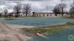
In order to view modeled flood results with AR technology, the city used FloodVue®, an application developed by Wood PLC, a consulting and engineering company. The application enables users to drape a modeled floodplain onto nearby physical terrain with an iOS or Android device. Using the device’s camera, panning around allows the user to view flooding predictions directly on the device’s screen.
The application achieved this view by incorporating three elements: earth elevation, water elevation, and building footprints. Once gathered, all data was rendered into a 3D model in the app and was customized for the project specifics. These specifics included a toggle between pre- and post-mitigation water surface elevation results, as well as the ability to show flood depths directly on the mobile device’s screen as the user panned down toward their feet.
Once in the field, the Wood PLC team and staff from the city walked to various locations and performed a pilot test of FloodVue.
Initial tests indicated that the GPS embedded on the mobile device was problematic. Instead of relying on Bluetooth GPS antennae, the Wood team developed a custom approach to use the phone’s camera to scan the surroundings and determine a more precise location: it would use the phone’s GPS as a starting point and then use the surrounding features to narrow in on the user’s location.
Once implemented, the team revisited locations around the modeled area, including the city’s storage facility with known flooding problems and the site of the proposed detention pond. Flood depths were clearly visualized at the known locations, and city staff onsite even commented that they could remember when historic flooding conditions and depts occurred exactly as was modeled and displayed. Likewise, the city staff were able to confirm that critical and evacuation roads would not flood at the detention pond location during flood events, allowing the teams to determine and execute the best flood mitigation techniques moving forward.
Overall, using AR to visualize modeled floodplains was remarkably successful. The value of this immersive communication method was instantly realized by both the application’s development team and the client. Viewing the 2D maps of the mitigation effort, coupled with videos captured from the mobile device, developed a better picture of the modeled flooding and ultimately the benefit of the proposed flood reduction.
It is important to note that AR is not a means of replacing traditional communication efforts. Marrying traditional methods of mapping to display the full horizontal component of flooding with the AR allowed emergency management professionals, stakeholders, and community members to clearly see the importance of the proposed mitigation efforts and have confidence in using proposed public funds for the development of more resilient infrastructure.
Future enhancements of FloodVue are currently underway as Wood works with clients from all over the globe to learn more about their needs and how to more effectively communicate flood risk and flood mitigation. SW
Published in Stormwater magazine, August 2022.
About the Author
Daniel Gwartney
Daniel Gwartney, CFM, GISP is the GIS Group Lead and Associate Geospatial Scientist for Wood PLC’s Environment & Infrastructure Kansas Operations. He has more than 15 years of experience in the GIS industry with specific emphasis on floodplain modeling and mapping, with more than 10 years directly related to working with Remote Sensing and LiDAR data products.


