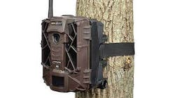
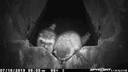
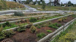
Game cameras or game cams are small, rugged outdoor cameras used primarily to capture photos of animals. They have a long battery life and are built to withstand harsh weather conditions. Depending on the deployment duration, site access, and visitation frequency, the game cams can be powered by conventional batteries (AA size), large battery packs, or solar panels. Most models have an infrared flash so they can also shoot in the dark, either at night or underground pipes.
Photos stored on memory cards can be downloaded during site visits or accessed remotely using cellular telemetry. Several models have cellular telemetry and upload to a website so photos can be viewed remotely on a PC or mobile app. Cellular telemetry and data plans add small costs but the price increase is offset by reduced staff time for site visits and the value of near-real-time observations and data validation.
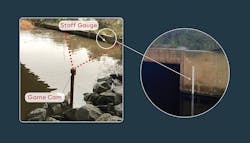
Game cams traditionally operate as motion-activated cameras to capture wildlife, but many have a time-lapse mode to capture images on a user-defined interval. Photo intervals can be set as frequently as five minutes, but we find hourly photos provide a good record of flow conditions without overwhelming storage and analysis burdens.The game cams are available with a metal security enclosure which can be used to prevent vandalism, and aids in mounting the game cam in various configurations. To increase their ability to verify water levels or flow conditions, a staff gauge or other visual water level reference can be installed within the view of the game cam. Horizontal lines can be drawn on v-notch weirs to provide an easy reference of water level and flow rate.
We implement a wide range of stormwater and non-stormwater monitoring programs at Wood. We use game cams in both types of programs to visually confirm and validate questionable flow conditions and data.
‘Dry Weather Flow’ Monitoring
Ensuring Valid Data
Data quality objectives for precision and accuracy can vary based on program objectives and intended data use. One example requiring highly precise and accurate flow data are MS4 non-stormwater flow monitoring programs that require interannual comparisons and regulatory percent reduction goals. The primary challenge with evaluating and comparing low-flow data is that flow rates are often very low (<1 gpm) and small changes in flow rates amount to large relative changes. For example, if average flow rates of 0.1 gallons per minute (gpm) are compared with rates of 0.2 gpm, the absolute difference of 0.1 gpm is very small but the relative difference is 100%. When regulatory goals are for 10 to 20% reductions, the data quality issues are a significant challenge, and even small inaccuracies raise questions, and eyebrows, regarding validity.
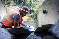
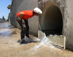
Wood conducts continuous dry weather flow monitoring at 40 to 50 MS4 outfalls each dry season (May to October). We mainly use custom made, sharp-crested v-notch weirs and METER CTD sensors to record water level behind the weir. Flow is calculated from water level data using a standard equation.
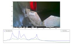
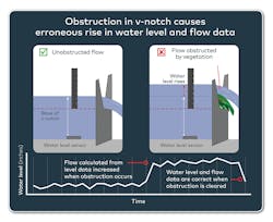
V-notch weirs are highly accurate and more precise than monitoring without a flow control device, but they are prone to being blocked or obstructed by trash or vegetation. Obstructions in the v-notch artificially raise the water level behind the weir, leading to erroneously high-water level and invalid flow data. Game cam photos are used to screen for obstructions and related erroneous data, to ensure an accurate and valid flow dataset.Comparing Photos with Flow Data
To efficiently review hourly photos and corresponding flow data for 40 to 50 sites, we wrote a Python app to display the photos with the corresponding time series data as well as the instantaneous flow and water level values. The photos can be quickly viewed using the keyboard arrow keys to advance through time and see the corresponding flow and level data simultaneously. In addition to spotting obstructions, lines on the weir are used to visually confirm the water level data. Obstructions or other issues are noted, and the erroneous data is removed from the dataset.
Another part of a non-stormwater flow monitoring program can be to dispatch inspectors to investigate high-flow events and find their source. Since both the flow data and game cams upload to a website in near-real-time, we can confirm a high-flow event before dispatching inspection staff. This prevents wasted effort searching for sources if the elevated flow is erroneously caused by a piece of trash stuck in the weir. Routine checks of the data and game cams can also identify sensor malfunctions, measurement drift, and schedule maintenance instead of requiring site visits to identify issues.
Additional Water Quality Information
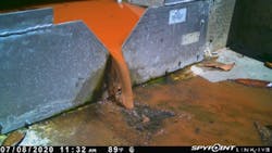
Photos from the game cams provide visual observations of other water quality issues like foam, high turbidity, oil, and trash. For instance, high flows from hydrant flushing or pool draining are usually very clear, while car or dumpster washing is accompanied by foam. Construction runoff often appears with high turbidity. These photos can provide some clues to flow sources or activities for inspectors to identify in the field.
Confirming Critical Flows
Game cams have also proven useful for supporting flow monitoring in stormflow conditions. Many regulatory drivers require load calculations that rely on flow data. One example would be for a sediment TMDL that requires annual load calculation. We use a sediment transport model that calculates annual sediment load based on peak flow rates of individual storms (Messina and Biggs, 2016). Accurate and precise data on peak flow rates for each storm are critical to the estimated sediment load and determining compliance with the TMDL. We deploy game cams at each of the monitored creeks, each with a staff gauge visible in the photo to verify peak water levels for each storm. Sediment or vegetation buildup causes standing waves, obstructions, and burial over the water level sensors, which are visible in the game cam photos. Without the game cam pictures, it would be difficult to flag these issues from the water level data alone. The record of photos adds a high degree of confidence to critical flow measurements.
Other Observations
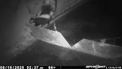
One of the fun aspects of the game cams has been seeing the variety of wildlife in the MS4. San Diego is a fairly dry place, so many animals are attracted to the water ponded up behind the weirs. Monotonous photo review is often broken by the sudden appearance of skunks, ducks, raccoons, owls, lizards, and frogs. It’s a good reminder that these water bodies and conveyance structures are actively used by wildlife for drinking, bathing, feeding, and shelter. Another reason to treat our environment with respect!
References
Messina, A. M., and T. W. Biggs. “Contributions of human activities to suspended sediment yield during storm events from a small, steep, tropical watershed.” Journal of Hydrology 538 (2016): 726–742.
About the Author
Alex Messina
Alex Messina, MS, Ph.D., is a Senior Scientist, Water Resources at Wood, an international engineering and technical consulting firm. Dr. Messina’s work has most recently focused on dry and wet weather monitoring in natural and urban systems and their impact on coastal water quality. As an Adjunct Professor at San Diego State University, Dr. Messina works to create and strengthen collaborations between government, NGO, private, and academic research partners.
Jeremy Burns
Jeremy Burns is a Senior Associate Scientist and Project Manager at Wood. Burns also serves as a monitoring technical lead for Wood’s San Diego, CA-based California Stormwater group. His focus is on monitoring program development, instrumentation, and implementation that provides answers to study questions.
