There is a saying that the only thing constant in life is change. In the realm of coastal environments, nothing could be more true. The shifting winds, the tides, and rains are what has created the often beautiful vistas of coastal landscape, the diversity of habitats and ecosystems: stones ground into pebbles by the shifting surf, pebbles into sand and even finer granules, and those constituents, after chemical changes and biological transformations, subsequently broken down into their essence as minerals and nutrients, consumed and reassembled to sustain the life forms that make their homes along the shore and out to sea. Society, too, has benefitted from the constant change at the edge of the oceans, as illustrated by the web of cycles of life on the coast, giving rise to fisheries and commerce. The sights and sounds draw tourists and settlers, while communities thrive on harnessing the energy interchange and partaking in the dazzling material results at the interface between the land and sea.
However, despite the seemingly enormous timescales of the evolving geography on the planet, coastal erosion can change the environment as quickly as the course of a day or two. Although scientists recognize that any illusion of stability in coastal zones is fleeting, daily life of society relies upon stability and reliability, a reality not promised by the coast. Although habit inspires the perception that permanence is both universally desirable and obtainable in practice, few things could be further from the truth.
From a geomorphological perspective, experts say any attempts to reinforce or solidify the line in the sand to enforce permanence on the shoreline often results in accelerating and intensifying the rate of change elsewhere on the coast, sometimes as near as the neighboring parcel.
Today, with observed phenomena of climate change, rising sea levels, and land subsidence taking place in many areas, experts believe consideration must be given to adopting the stance of children playing in the sand, who step back and watch with a combination of awe and fascination as their castles melt into the waves. But in many instances we have invested far too much in coastal assets to simply step back as those resources fall to the sea. Fortunately, science has advanced to the point that there are alternatives. The Nature Conservancy has teamed many of these advancements with careful analysis and an emerging practical knowledge to understand change in the coastal zones and, when necessary, consider strategies to redirect change, all the while with the realization that standing in the way of the forces of the sea will come with a price.
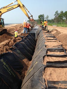
Technicians fill cellular containment modules with sand quarried in New Jersey.
A Fortress of Sand Defends a Community
The variability and fluidity of the coastline is a reality not lost on Elizabeth Jordan, senior project manager for New York City Department of Parks and Recreation. As the largest single owner of coastal property in the City of New York, her agency has responsibilities that go beyond providing for recreation and enjoyment of nature to actually ensuring the safety of the public, homes, and other infrastructure against ocean waves, storm surges, and windblown surf. Most of the City’s 578 miles of coastline falls under the jurisdiction of the Department of Parks and Recreation.
Jordan has witnessed firsthand the devastation that can occur on the coast from hurricanes and nor’easters. Working as part of the department’s emergency response team in the immediate aftermath of Hurricane Sandy, Jordan ventured out to help community members in recovery efforts for Rockaway Beach, one of the hardest-hit areas. She was astonished to see that the entire boardwalk had been pushed, by the force of the waves, into the adjacent neighborhood. The storm surge, amplified by the spring high tide, brought a combination of floods and smashing breakers to the area, blasting timbers from the boardwalk and hurling them through the streets. According to Jordan, in the area adjacent to the shore, “All of the houses were gone.” In addition to widespread inland flooding on Staten Island, she says, “We lost a significant amount of shoreline.”
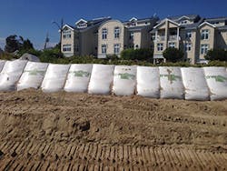
Barrier Force protects homes on Sprague Avenue.
Looking back at the long-term effects of the storm, she says the loss of the dunes and beach erosion made these same coastal communities vulnerable to ongoing erosion damage and flooding during seasonal storms of a much lesser magnitude than Sandy. To counteract this immediate threat, the Department of Parks and Recreation, along with the US Army Corps of Engineers (USACE) and other partners, implemented a series of emergency protective measures on Staten Island and Rockaway Beach, Queens, designed to protect lives, homes, and properties on an interim basis until a permanent and comprehensive storm-risk reduction strategy could be put into effect.
The Department of Parks and Recreation performed a light detection and ranging (LIDAR) analysis of the shoreline to identify areas below the five-year still water level, which Jordan describes as the equivalent of the average height of wave action and tidal action. The department then installed a barrier system surrounding the low-lying areas to fend off the waves and surges associated with seasonal storms. Jordan designed a temporary wall of protection that stretched along 3.9 miles of oceanfront on the South Shore of Staten Island and another installation that provided 4.5 miles of protection along the Atlantic coast in Rockaway Beach.
The wall was constructed using sand-filled cellular containment bags made by Barrier Force. The Barrier Force modules are manufactured in 2-, 4-, and 6-foot-tall containers made of high-strength polypropylene fabric. Designed with a trapezoidal shape, they allow wave energy striking the face of the module to be dissipated as it travels up the slope, reducing the force of the wave before it can affect infrastructure. The lid on top prevents liquefaction of the sand within.
Quick Work in the Cold
According to Jordan, most of the Barrier Force walls set up on Staten Island were installed as double bag berms. The trapezoidal bags were filled and linked back to back, forming a triangular mound upon which sand was piled and planted with beach grasses. The Department of Parks and Recreation used the same product to build the temporary emergency protection berms in Rockaway Beach; there, however, because of space constraints, a single row of bags had to suffice.
“We were doing it in an emergency capacity, so we were moving very quickly. We were also doing it during the winter months, so having people out in the snow and the rain and the cold temperatures is always challenging for the contractor,” says Jordan, grateful for the efficiency of installation.
Describing the streamlined workflow using Barrier Force, Jordan says, “They are not very complicated to install.” Delivered in 100-foot sections, each with 33 cells, the modules attach to one another side-to-side and front to back with metal rings called hog rings. “They have a frame that the bags go into and then they are filled with sand, either mechanically or hydraulically, that is then compacted. The lid is placed on them and sand is graded on the top,” explains Jordan. Each 100-foot section installed on Staten Island was filled with 73 cubic yards of quarried sand weighing 94,000 tons delivered from New Jersey. “When you think about two sections of these back to back, that’s a significant barrier,” says Jordan.
In spite of the ease of installation, Jordan says the challenge was that the emergency protective measures project represented the first time the Barrier Force system had been used for an oceanfront shoreline protection project. “We worked very closely with Barrier Force to take the bags from what they were originally designed for, which was flood protection in river settings, and modifying them to be applicable to shoreline use.” For instance, the company increased the strength of the containment system to allow it to withstand waves in addition to the hydraulic pressure encountered in rising water scenarios. Jordan says Barrier Force also modified its product for speedier installation by replacing individual separate lids with an integral lid system, helping meet the project’s accelerated emergency installation timetable. The company paid attention to aesthetic detail as well. “While it may not sound like a big thing, the original Barrier Force bags were manufactured only in black geotextile, but they started manufacturing white ones for us, because nobody wants to see black bags on the beach, and these are a lot less visible,” says Jordan.
Although the containment system that protected Rockaway Beach through several seasons has been removed for the construction of the new boardwalk, the Barrier Force system installed to protect Staten Island remains in place, fortifying the oceanfront.
“There have been a couple of nor’easters; we’ve had king tides and we’ve had a couple of near misses,” says Jordan. “In a lot of these places the winter storms generally push the waves up pretty high—there are some locations where they hit the bags.” While she concedes that a few of the Barrier Force bags have lost a small amount of fill to hard-hitting waves, and a few have been targeted by vandals who cut them with knives, the maintenance requirements have been minimal. She believes the results have demonstrated a big improvement over prior practice, which, she says, consisted of individual homeowners hearing forecasts of incoming storms and rushing to stack ordinary sandbags in front of their homes, hoping the waves wouldn’t get big enough to drag the bags out into the ocean one by one. Overall, Jordan says, the Barrier Force system “has been the front line of defense for these communities ever since they’ve gone up. If you look at the map of Staten Island, you can see there are residential communities directly adjacent to the beach, and these bags have provided significant protection for these communities since they’ve been there.”
Just the Beginning
“All of the coastal cities are struggling with the same questions,” says Jordan. “What do you do with climate change and sea level rise?” Without diminishing the importance of emergency coastal protection measures, she says, “The coast is a changing entity. The City of New York is at the forefront of a lot of the work in investigating ways to help maintain the shoreline.”
A recent study performed by the Nature Conservancy in Howard Beach on behalf of the City of New York found that combining natural and gray defenses holds the most benefits. Although Howard Beach was hard-hit by Hurricane Sandy, analysis showed that a hybrid alternative of gray and green infrastructure could result in avoided losses in this one neighborhood of up to $244 million from the current one-in-100-year storm event.
Jordan notes that New York City is considering implementing living shorelines and other “natural measures that can encourage sedimentation in some areas or to help maintain the width of the beach in other areas. We have some pretty amazing projects that are moving forward. There’s a project in Staten Island that the City is doing to build an offshore breakwater on the southern tip of the island to stop erosion and create some sedimentation, to help build up the shoreline a bit. There’s a lot of new information that can help.”
A Quarantine for Waves
After witnessing the destruction Sandy brought to New York, Jon Kachmar says Boston was lucky to skirt the devastating storm, but as the Nature Conservancy’s urban program director, he says the thought came to mind that “we may not do that the next time.” According to Kachmar, it inspired leaders of towns and cities in the Boston area to look for ways to address this concern for the long term.
Kachmar says it’s possible that 34 small islands that speckle Boston Harbor, making up the Boston Harbor National Recreation Area, will play a key role in that effort. According to Kachmar, the collection of islands already serves as much more than scenic respite. When vicious nor’easters or the remnants of hurricanes pass along the coast, the islands help buffer the waves, providing downtown Boston with natural protection from high tides and storm surge. But, he says, with sea levels rising and storms intensifying, these natural buffers may, in time, prove insufficient to protect downtown sea walls from overtopping during storms or extreme tides.
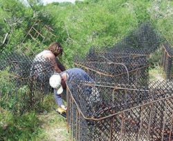
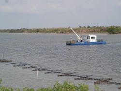
Technicians construct ReefBLK gabions at Mad Island Marsh Preserve.
A Beacon and a Bellweather
Among these tiny spits of land sits on Gallops Island, once used to quarantine 19th century immigrants on their way to Boston from Europe. In historic times, the prevalence of the smallpox virus outside the US necessitated a period of quarantine for many of these travelers. Sadly, officials and caregivers on Gallops Island watched more than 200 new arrivals die while still in quarantine, never to set foot in the City. Gallops Island also served as an internment site for captured German merchant sailors during World War I. During the 1918 Spanish flu epidemic, the tiny island housed some of Boston’s influenza sufferers while researchers attempted to gauge the virulence of the disease. That experiment ended abruptly when the lead scientist contracted a fatal case. The island later housed a radio school for soldiers preparing to serve in World War II, as well as a school for bakers.
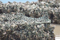
Coastal Environments’ boat installing ReefBLK gabion cages filled with oyster shells at Mad Island Marsh Preserve in 2005.
Now the island sits uninhabitable, contaminated with asbestos from the debris of its small complement of disused and demolished structures. Although situated in and designated as a part of Boston Harbor Island National Recreation Area, it is now considered a safety hazard and is closed to the public. However, in the near future Gallops Island may be destined to perform its greatest service to Boston ever. New experiments planned for the island are being designed to test an innovative approach to reducing the risk of flooding in the center of the city.
As far back as the 1880s, administrators operating the various health, immigration, and internment facilities on the island had complained of the effects of erosion on its shores. History records sea walls built and reinforced several times on Gallops Island before the 20th century by laborers, craftsmen, and even prisoners. However, Kachmar says, even today the island continues to shrink, and should islands such as Gallops Island vanish beneath the waves, Boston would stand to lose a vital natural defense against the fierce storms endemic to the region. To help meet this challenge, the City of Boston partnered with the Nature Conservancy and the USACE to design and implement an artificial offshore reef at Gallops Island to test an innovative coastal protection strategy.
“We know there is erosion,” he says. “There is some infrastructure in terms of a pier and a traditional jetty that are threatened by the erosion, but there is no private infrastructure and no houses. It seemed like a good place to try to demonstrate if we could build these submerged reefs and have some public value by protecting a state island. And if we scaled that up, we could do it in multiple places in the harbor over time that would have some collective storm surge risk reduction value to greater Boston.”
Minimizing Impacts on Sedimentation
In concept, the reef will protect the south-facing shore of Gallops Island while allowing for the normal transport of sediment along shore. The project is planned to make beneficial use of rocky dredge excavated by the $310 million USACE Boston Harbor dredge project planned to begin in 2017. Irregular rocky material transported from the dredge project and dropped on the bay floor a few hundred feet offshore is expected to accrete sediment and eventually provide diverse habitat, supporting the continued recovery of the local ecosystems.
Although Kachmar says there had been discussion of building a barrier all across Boston Harbor, similar to what has been proposed for New York Harbor to protect New York City, state agencies and the Nature Conservancy have also expressed a keen interest in keeping adverse impacts of shoreline protection installations at a minimum.
“Our impetus is to try to find solutions that are in between—that would not be detrimental to one side or the other.” He says the approach involves “thinking proactively about how to start building nature-based infrastructure, amounting to a hybrid between manmade and natural, and how we could demonstrate it.” Multiple partners including the USACE, the City of Boston, and the Nature Conservancy evaluated the entire Boston Harbor for sites to locate a project focused on providing positive environmental benefit through wave attenuation along with coastal erosion prevention, while supporting the “habitat value of Boston Harbor.” Kachmar notes that through decades of successful pollution control strategies, the harbor’s habitat “has improved vastly to become quite a productive system again.
The plan for the reef structure is simple. It is envisioned as a mound of rocky material 1,000-feet long, 100-feet wide, and 19-feet high, submerged in 22 feet of water and located between 300 and 400 feet offshore. While Kachmar says the site is “mostly subtidal,” he notes, “During very low tides there will be times when the top of it is exposed.”
Preliminary work has begun with the initiation of wave energy monitoring protocol. The goal is to determine the wave period and wave height at sample sites to understand how a potential reef could attenuate different wave periods and heights. These data will serve as a preconstruction baseline to be compared with conditions after a reef is deployed and as a monitoring tool to determine if the reef continues to have wave attenuation capacity over time.
A key aim of the project is to allow the transport of sediment between the structure and the shore, so that while it’s providing wave attenuation, “it is not obstructing sediment flow, which is the real engineering challenge that led us to the size and the location. We’re trying to avoid what we know are the downsides of traditional coastal engineering structures,” he notes.
Although Kachmar says there are numerous projects around the country focused on the individual goal of wave attenuation, and other projects primarily focused on improving habitat, the Gallops Island wave attenuation project “would be the first combining the two objectives in one overall effort.” The near-shore environment will still move sediment, Kachmar says, but the attenuated waves “won’t move as much sediment” and “the structure won’t disrupt the flow of it, especially during large storm events, which is the problem.”
He notes, “Parts of the Boston area are developing rapidly, and there is a lot being invested just to keep the water from flooding into the buildings and into the streets. There is clearly an infrastructure component that needs to be considered. There are areas where walls will need to be built.
“Our theory is if we can slow the water on a larger scale—if we could build underwater reefs that don’t have negative impacts, but that slow the water just by creating greater friction at a large enough scale around the harbor—could we, in places where we have to build walls, build them lower? Would they have to be such a significant investment if we slowed the water before it got there?”
Creating Habitat to Protect a Coastline
Mark Dumesnil says he has seen the coastal erosion slowly reversed by hybrid solutions implemented along the Intracoastal Waterway near Galveston Bay, TX. According to Dumesnil, Nature Conservancy associate director of coastal restoration, the Intracoastal Waterway has suffered incredible erosion. “It was originally 100-feet wide and 19-feet deep when it was first constructed back in the 1930s. We’re now seeing shoreline to shoreline, 400 to 500 feet, so clearly there is aggressive erosion that has taken place over the years, particularly in the latter half of the 20th century.”
For Dumesnil, protecting the coastline means more than shoring up the beachfronts or the bluffs overlooking the ocean. In a coastal environment such as that surrounding the Intracoastal Waterway, he says, there are certain places he refers to as “tertiary bay systems” that operate in the background to promote the stability of the coastline from the inside out. These tertiary bay systems flow into coastal systems such as the Intracoastal Waterway, supplying freshwater from the mainland that supports the plant and animal life. The inflow of freshwater, he says, is critical to the survival of the coastal marshes and thus is important in protecting the coastline itself. “If we can protect the integrity of those areas, we can help to impede saltwater intrusion into those marshes. When you get saltwater intrusion, the productivity goes down. They go from being fresh and brackish to being very saline; when that happens biodiversity goes down and you start to lose the integrity of the marsh.”
Observing that the erosion on the Intracoastal Waterway near Texas midcoast had begun to threaten critical habitat on a Nature Conservancy preserve during the 1990s, Dumesnil began experimenting with several soft solutions to hold the line, such as “coconut rolls, round hay bales, and Tensar fencing. I couldn’t afford to put any heavy structures in the water—I didn’t have the funding for it,” he says. But he did have the inspiration to boost the capacity of technology by matching it up with nature. In 2006, with access to mitigation funding, he began experimenting with installing gabion-like structures called ReefBLK manufactured by Coastal Environments Inc. of Baton Rouge, LA. They consist of a system of vertical oyster reef configurations, fabricated metallic rods linked together using wire mesh in a unique design that has been proven to provide efficient erosion control, shoreline protection, habitat development, and rapid sediment accumulation.
Nature Conservancy crews and volunteers filled the ReefBLK gabions with oyster shells, placed them about 35 feet offshore, and waited. As expected, oyster spat began to colonize the structures. “In less than a year we started to see a tremendous amount of accretion of fine sediment back behind those structures—on the order of 8 inches to a foot,” Dumesnil says. The process has since been replicated in Alabama, Louisiana, and Florida. As a bulwark against erosion, in fact reversing the trend, “it has worked quite well,” he says.
From a marine perspective, he says, the numerous small bays that feed into the Intracoastal Waterway “are most productive when they are brackish, so the erosion protection strategy that we have is to try to impede that saltwater intrusion into those brackish systems.”
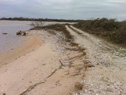
This area, photographed in 2015, shows the typical character of shoreline loss occurring along unabated sections of the Gulf Intracoastal Waterway and at Mad Island Marsh Preserve.
Weaving a Web of Resilience
The challenge of sea level rise is not so much a question of whether the sea will rise or when; rather, the question the Nature Conservancy and many partners have begun to ask is, what we should do about it? There is no one-size-fits-all answer. However, the Nature Conservancy has developed a new suite of analytical software packages, which it calls the Coastal Resilience Tool, to provide a framework to help resolve that question on a case-by-case basis.
The tool is designed to take a complicated model of coastal processes and “turn it into something people can understand,” says Zach Ferdana, senior marine conservation planner for the Nature Conservancy. It evolved from a dialogue that began 10 years ago among Nature Conservancy partners, government officials, county planners, and engineers serving the towns and villages on New York’s Long Island. “They were concerned about sea level rise and storm surge affecting their coasts. They felt they didn’t have the information necessary to make informed decisions about the future development of the coast. So we came up with this approach, and the mechanism of the approach is the set of online web mapping tools,” says Ferdana.
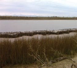
Low tide at the Gulf Intracoastal Waterway. After several growing seasons, clumps of oysters and emergent marsh grasses colonize the area surrounding the gabions.
The multilayered, interdisciplinary mapping tool views the coast from a sea level rise and storm surge coastal hazards perspective to assess the social, economic, and ecological assets of the coastal community, mapping them together to support sound decision-making on the direction development should take to minimize risk and actualize opportunities.
With the Coastal Resilience Tool, coastal communities and decision-makers can explore different flooding scenarios, from sea level rise to storm surge; analyze the potential impacts on communities, natural resources, and critical infrastructure like roads and schools; and develop solutions to address these realities. The tool can be accessed online.
New Tools, Wider Options
“Decision-makers and planners need a clear and compelling case for their constituents, which coastalresilience.org provides,” says Dr. Nicole Maher, the Conservancy’s wetlands specialist for Long Island. “This tool will help determine which parcels of land should be preserved, how to manage land for responsible and more resilient development, and how to prioritize which wetlands should be restored to protect our coastal communities.”
The tool allows the user to envision the coastal environment from several different perspectives, including community planning, future habitat, flood and sea level rise, and exploration of risks.
The Community Planning app is the location where resilient communities host their locally specific data to guide their decisions and track their successes. The Future Habitat app categorizes various tidal marsh advancement scenarios from spatial model outputs. The Flood and Sea Level Rise app can be used to view areas as they appear today and as they might appear in the future due to increased sea level rise, surge from storms and hurricanes, and inland flooding. The Risk Explorer is organized by state and permits users to easily visualize coastal hazards exposure, social vulnerability, and overall risk. The app allows users to explore where people and properties benefit most from the risk reduction provided by enhanced habitat.
Ferdana says the tool also gives the Nature Conservancy “a great opportunity to promote nature-based solutions as alternatives to sea walls, dikes, and levees, and, in places where they’re appropriate, to promote hybrid solutions coupling green and gray infrastructure.”
Explaining the urgency of promoting resilience, Ferdana says, “We have to match the rate of threat to our coasts with the rate of restoration and conservation we need to do to be successful. We really take the coast seriously from a community standpoint, recognizing that safety is important—recognizing that levees, dikes, and groins have a very important place, while also recognizing that there need to be alternative approaches where maybe the marsh can do that job.”
There is now a network of coastal resilience projects using the Nature Conservancy framework in 17 of the 23 coastal states. “It is a very bottom-up approach. We are building and customizing web-mapping technology to meet community needs,” he says.
“Hybrid solutions and green solutions and gray solutions are very place specific. We do a lot of modeling to understand that place-based specificity,” says Ferdana.
