Strengthening Shorelines With Hard Armor
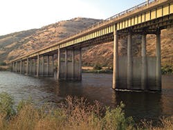
Spalding Bridge
Perhaps the slopes are too steep. Perhaps the current is too strong. Perhaps both, and maybe some other challenging site conditions exist as well. Some projects along bodies of water require extra-strong measures to stop erosion. One of those projects is in Idaho.
The Clearwater River runs for 75 miles west from the Bitteroot Mountains at the Idaho-Montana border to where it flows into the Snake River near Lewiston, ID. The pristine river is a draw for people who like to go fishing or boating. Its whitewater rapids are popular with rafters and kayakers.
The Clearwater is the largest tributary of the Snake River. The Middle Fork of the Clearwater was one of the first rivers to be listed for protection under the federal Wild and Scenic Rivers Act.
Built in 1962, the US 95 Spalding Bridge spans the Clearwater River about 10 miles from the city of Lewiston. Constructed with a concrete deck and steel girders, the bridge is more than 1,200 feet long and about 33 feet wide. Commuter traffic passes over it every day.
But weather and time had contributed to the deterioration of the bridge. The major cause of the poor condition of several of its eight supporting piers was erosion of the riverbed from the swiftly moving water flowing by.
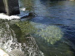
A-Jacks protecting a bridge pier
The Spalding Bridge was in such bad shape that it was on the list of the 10 most-scoured bridges in the entire state. It was in danger of failing, which could have resulted in serious injuries, even death, for some of the people who traveled across it.
The solution for preserving and stabilizing the Spalding Bridge lay in stopping erosion of the riverbed. The solution had to be strong enough to last for years. Designing the best solution fell to the engineers at the Idaho Transportation Department (ITD).
The product they selected to do the job was A-Jacks—almost 400 mats made up of the interlocking concrete units. The A-Jacks (14,982 of them) were 24 inches in size. Each mat weighed 2,700 pounds. A-Jacks are from Contech Engineered Solutions of West Chester, OH.
Installing the mats was challenging work for several reasons. Current in that section of the river averages 15,300 cubic feet per second, far too strong for divers to be safe in water that ranged up to 14 feet deep.
“Definitely, the speed of the water was challenging, and the water was fluctuating quite a bit,” says Joe Schacher, ITD’s then-resident engineer and construction administrator and now design construction engineer.
The Spalding Bridge is located between two dams. Schacher says that river’s temperature warms up during the summer. “One way they mitigate the temperature of the water to make it cooler for the fish [who are stressed when the water is too warm] is to release water from the upstream dam.”
Diverting the river, even temporarily, was not an option. It is a sensitive ecosystem that includes several threatened species of fish (bull trout, Chinook salmon, steelhead, and cutthroat trout). Members of the Nez Perce tribe, native to the area, rely on these fish for food just as their ancestors did.
Lowering the bundles of A-Jacks from the side of the bridge was another option that was ultimately ruled out. Using this strategy would have disrupted traffic on the bridge. About 5,700 vehicles cross the bridge daily—enough to cause traffic jams.
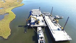
ITD engineers decided that the best way to get the A-Jacks where they needed to be for permanent placement was to transport them to the site by barge. An excavator on the barge was used to install the A-Jacks under the water.
Although the clear water provided good visibility, the operator moving the A-Jacks from the barge to their precise placement did not have the view that onsite divers would have had. The solution was to use a GoPro camera.
“We taped a waterproof GoPro camera near the end of a piece of rebar so it held steady. The operator could see a picture on his cell phone of the blocks in real time,” says Schacher.
Working in water means adapting to changing conditions, and the Clearwater River changed often while work was in progress. For about a week, the river’s flow dropped to 7,980 cubic feet per second. This change kept the barge from approaching the piers downriver, as the lower water exposed gravel bars.
Another challenge was working in the midst of people using the river for recreation. “We had to leave the river open to the fishermen. We weren’t allowed to hold them up,” says Schacher.
ITD worked closely with the Nez Perce tribe’s employment rights office, the Idaho Department of Fish and Game, and EPA to be sure the habitat was protected. Half of the workers on the project were Nez Perce tribe members.
Spalding Bridge
Work on the bridge started on August 4, 2014, and was done 29 days later, ahead of schedule and $30,000 under budget. The work was finished and all equipment was removed just before the start of the catch-and-keep fall fishing season.
Schacher attributes the reduced work time and cost to the contractor’s experience and the use of the underwater camera. “No diving crew means no time waiting while they put equipment on, and no multiple diving crews because they can only stay in the water so long.”
The West Companies served as general contractor for the Spalding Bride project. Design and other engineering work was done in-house by ITD.
Schacher says the reinforcement “is working great. It has handled spring floods well. We get two flash floods a year—when the first rains hit the snow in January to February, and then in June when warm weather hits the snow pack in the mountains.”
In 2015, this bridge project was awarded a prestigious President’s Award for environmental stewardship by the American Association of State Highway and Transportation Officials (AASHTO). The project was also cited as an AASHTO Innovative Initiative—an example for other state transportation departments to use.
ITD had won four previous AASHTO awards. The award for this project was especially meaningful because there were so many restrictions and challenges to overcome.
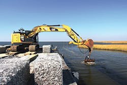
Placing gabions from the barge
Restoring Louisiana’s Coasts
Despite their hard shells, oysters are fragile creatures. The high demand for them by the food industry plus their need for secure aquatic habitats in which to grow has caused scarcity among the oyster population.
Among the oyster-producing states, Louisiana ranks third. With its mission to protect and restore, when possible, the coastal areas of the state, the Coalition to Restore Coastal Louisiana (CRCL) developed a strategy to help oysters by increasing their habitat.
That strategy involves constructing a particular type of reef, composed of oyster shells and supporting and stabilizing materials. CRCL worked with The Nature Conservancy of Louisiana and ORA Estuaries, a coastal engineering firm, on the reef’s design.
The program has grown into the largest oyster shell recycling program in the country. Twenty-six restaurants in the New Orleans area dump oyster shells from diners’ plates into purple bins. Five days a week, CRCL employees deliver clean bins for the next week’s collection and remove the bins full of discarded oyster shells. Smaller restaurants use one bin, but some of the larger restaurants will fill two or three bins each week. The program began in June 2014 with a campaign to persuade restaurant owners to participate. It took some time to accumulate enough oyster shells to build the first reef.
The reef was constructed in Biloxi Marsh (within St. Bernard Parish), about 20 feet from the shore of Lake Athanasio. The staging area was in Buras, LA. This site was ideal because high waves had been causing erosion along the shore. The reef would not only shelter the growing oysters, but also weaken the force of the waves, thus slowing erosion.
“We knew this intertidal location would make a good oyster habitat and make a good marsh habitat,” explains Deb Abibou, restoration projects director for CRCL. She explains that improving marshes is critical in coastal areas such as Louisiana. After a storm causes damaging surges, “A marsh is like a protective sponge [for areas inland].”
The reef was constructed of 1.7 million pounds of oyster shells and a supporting framework of gabion baskets. Each of the 434 galvanized wire gabion baskets was filled with roughly 4,000 pounds of oyster shells.
CRCL volunteers partially filled bags with the shells. Then the bags were taken to a site where they were completely filled. A crane placed the bags on barges for transport to the project site.
The bags are aquaculture-grade nylon mesh that won’t biodegrade. The oyster spat will settle and secrete a cement-like substance onto the bags. That will hold the growing oysters onto the outsides of the bags.
The gabions used in the reef are from Modular Gabion Systems, made by the C.E. Shepherd Company of Houston, TX. The 3- by 3- by 6-foot gabions were modified to have smaller-than-usual mesh openings so that the shells would not washed out of them.
The gabions were placed individually on a geotextile grid and then wired together, like the cars in a train. The 3-foot-high reef is visible at low tide. For the safety of boaters and fishermen it is clearly marked.
The reef extends for half a mile. It has three openings to allow water and fish and other wildlife to move in and out.
The installation of the reef “went great,” says Abibou. “All the permits were in place and the weather was good.”
It took one day for the barges and construction equipment to be moved to the site. The reef was finished four days later, in November 2016. LeBlanc Marine served as general contractor.
“The reef is not for harvesting [oysters]. It has plenty of room for oyster larvae in the water to settle in and grow. Once they grow, they stay. In a year they grow to be full size and produce larvae that are food for the fish,” says Abibou.
Besides providing food for fish and other wildlife, the oysters will improve the quality of the water in the marsh. “One oyster can clean up to 50 gallons of water per day. They remove the nitrogen,” she explains.
CRCL has set up some monitoring of the area. The marsh itself—what vegetation is growing there and what aquatic vegetation is in between the marsh and the reef—is being recorded. A shoreline profile is also being developed with a highly sensitive Differential Global Positioning System (DGPS), which can detect changes in the shoreline as small as a centimeter. Photographs of the same places are taken at regular intervals, and the oysters themselves will be closely observed.
Abibou says the oyster reef is serving the fishermen of the area. They’re out on the water daily, know the area well, and will be keeping an eye on their community’s reef.
Shell Oil Company donated $1 million to get the program started. Other donors were the Coastal Protection and Restoration Authority and the National Fish and Wildlife Foundation. Program partners included The Nature Conservancy of Louisiana and the Louisiana Department of Wildlife and Fisheries.
CRCL is busy securing funds for another oyster reef installation. This one will be in Barataria Bay.
A barge was used to transport and place the gabions.
Safeguarding the Dallas Water Supply
Lines that supply water to a city need to be protected from damage by Mother Nature, including damage from erosion.
Dallas Water Utilities is the municipal utility that manages water service and wastewater treatment for local residents. Some of its supply lines run parallel and close to the Trinity River. Over the years, flash floods from storms and changes in the river’s depth and course had caused its banks to erode. The eroding banks were very close to sections of a major 72-inch water supply line. This proximity raised much concern for utility officials.
If erosion of the riverbank continued unchecked, the water supply line would eventually be exposed. The Trinity River has a history of flooding. River debris, especially items swirling by during flash floods, could hit the exposed line and break it open, disrupting water service to thousands of Dallas residents.
“It’s a critical water line for us because it provides water to a big portion of Dallas,” says Eduardo Valerio, senior program manager for Dallas Water Utilities.
The restoration project began when Dallas Water Utilities hired AECOM, a consulting engineering firm. AECOM’s engineers evaluated the erosion along the river and provided a design for the work. They recommended the use of gabions and other structures made by Maccaferri USA of Williamsport, MD.
“There were four erosion control sites [that needed to be stabilized],” says Valerio. These sections were within a 6,500-linear-foot stretch along the riverbank. Protecting them and securing the soil around the water line required some strong measures, including a gabion wall reinforced with soil nail anchors and gabion mattresses with a gabion toe.
The soil nail anchors, measuring 82 to 106 feet in depth, were used to hold back the gabion wall. Concrete pillars were driven 46.5 feet straight down to serve as deep toe anchors.
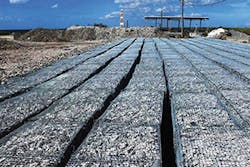
The Maccaferri gabions are baskets made from 8- by 10-millimeter double-twisted hexagonal woven steel wire mesh (ASTM A975 standards). Filled with stones at the site, they form a retaining wall. The gabion toe prevents slope erosion and scour in front of the wall.
The Maccaferri gabion mattresses are made from the same size of woven steel wire mesh. A lid was added as a separate panel. The mattresses are divided into cells to restrict movement of the stones and for extra strength.
The work was done by DCI Contracting Inc. of Decatur, GA. The construction crew put stones into the gabion baskets and mattresses by using a 450 Hitachi excavator with a 60-foot-long stick attached.
To install the soil nail anchors, crew members mounted a model 24HD REV Drill to a Komatsu PC300 hydraulic excavator. This drill allowed the workers to drill 12 feet over or under the work platform. The eight-member crew averaged 48 cubic yards of installation per day.
The project was finished in October 2012. It was done by sections and over the course of about two years. “We prioritized the work. The first year we did the major, more critical areas. The next year we did the other sections,” says Valerio.
The Dallas area suffered major flooding in 2015. Four upstream dams were in full, uncontrolled release. Valerio says the water lines were not at all affected by the disaster.
“The project was very successful. We were able to protect our water lines and to extend the life of water lines. The pipes were found to be in good shape, so we didn’t need to replace [all of] them, only a few short lines,” says Valerio.
He adds, “If we hadn’t done the project, we would have had to spend a lot of money replacing lines. And we were able to avoid a major emergency repair.”
Hutchinson Island
Hutchinson Island is a barrier island off the east coast of Florida. It lies opposite the mainland counties of St. Lucie and Martin and is, therefore, a part of both.
The main road running the length of Hutchinson Island is State Route A1A, aka Ocean Drive. Storms had damaged part of the narrow shore side of A1A, and the Florida Department of Transportation (FDOT) wanted to stabilize the shoreline and protect the road. Any further erosion could have undermined a 1.1-mile section of the road. If that happened, residents and employees of Florida Power and Light’s nuclear power plant would have been denied access.
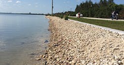
The solution was to install a wall between the edge of the road and the narrow shore. This wall—all 16 vertical feet of it—is below grade. It measures 1 mile in length. Storm requirements meant that the wall had to be able to withstand being exposed by a hurricane to the depth of 6 feet.
The wall’s top 1 foot is embedded in a 2-foot by 2-foot concrete cap. The top of this cap is at grade level so that if the wall is exposed by a hurricane, it will remain stable and intact.
The wall extends 16 feet below ground between the road and the shore.
The usual wall materials, such as steel sheet pile or concrete, were not good choices here. The corrosive saltwater environment made them questionable.
“FDOT envisioned using steel sheet pile or concrete, but steel sheet pile was at least double the cost,” says Chris Jackson, project manager, senior drainage engineer, and vice president with RS&H, an architecture, engineering, and consulting firm with offices in Jacksonville, FL, and other cities. Considering that most of the wall “would be buried and would only be exposed in the case of another washout, vinyl became an attractive option,” he adds.
The vinyl sheet piling selected for the wall was ShoreGuard SG-950 from Crane Materials International (CMI) of Atlanta, GA. Although the ShoreGuard would be unaffected by corrosion and looked like a good solution, none of the engineers or FDOT officials or the contractor, Zep Construction, had used it for such a large area. Before agreeing to its use, FDOT required that a test wall be built first to see how well the vinyl would hold up under the force of being driven into the ground.
“Vinyl sheet pile is thicker than steel sheet pile,” explains Jackson, and therefore is more likely to be damaged. “Steel can be hammered without damage.”
A ShoreGuard wall 20 feet long was built and driven to the full depth that the project wall would be driven. It was later removed and carefully examined to determine whether it had sustained any damage during installation.
The trial wall passed the test, though there were some problem areas. CMI supplied one of its PileClaw mandrels that had been designed for installing the large SG-950. Work then began on the real wall and was completed in May 2014.
The narrow site’s cemented sand layers and soil blow counts in the high 60s added to the difficulty of working there. But using this specially designed PileClaw allowed the contractor to install an average of 240 linear feet per day.
Noting that the project was finished early and under budget, Jackson says, “The sheet pile driving operation was pretty seamless. Zep and CMI just did a fabulous job working together.”
He says this roadway stabilization “wasn’t just a sheet pile project. It became much larger because of other constraints—the environment, traffic, utilities.”
The Indian Riverkeeper group and other environmental organizations were concerned about damage to the environmentally sensitive area in and around the adjacent Indian River Lagoon. RS&H engineers were, in turn, sensitive to their concerns.
“We held public workshops. We met with them individually and in the public meetings,” says Jackson. That effort paid off. “Our permitting process went seamlessly, without any concerns from environmental groups.”
Jackson says the A1A stabilization work is in good shape. “In October 2016, Hurricane Matthew passed through the area. There was some damage to A1A in the next county, but this project held up perfectly. The wall was designed in anticipation of scour.”
Erosion control projects that require stronger, heavier means to stabilize the soil tend to be larger and involve more complex designs. As these projects show, they also usually involve a fair amount of cooperation among a number of different governmental and nonprofit entities to see them through completion.
