Thinking Ahead of the Blaze
It was the summer of 1979 when I fought my first wildfire. As a wild land firefighter, I spent the summer building trails, fighting fires, and lugging equipment in the forests of Oregon and Washington. In those days, I always wondered about what happened after the fire crews, TV cameras, and politicians left. Would the environment survive? Would slopes fail? Would the vegetation come back? It wasn’t until I started my career as an agronomist and soil scientist that I was able to explore what was left behind. And, honestly, I was usually shocked. Although there are tremendous amounts of funds available during the crises, the funding became scarce after the flames were out.
That’s the idea behind proactive approaches to fire risk and erosion control. To ensure the best response possible to fire events, cities and municipalities should identify the areas with the highest probability of erosion, determine the best treatment processes and mitigation measures to control erosion and debris flows, and quickly fund and implement the recommendations to prevent post-fire landslides.
The Wildfire Environment
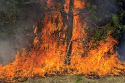
One of the primary challenges those responsible for mitigating post-fire erosion hazards face is admitting we still have much to learn about the wildfire environment. First, wildfires are extremely unpredictable, burning one home while an adjacent one is left untouched. Second, the rapidly rising column of hot air from a wildfire literally inhales oxygen to feed the base of the fire, creating winds of tornado speeds. The high wind carries embers a mile or more, igniting fire spots and spreading the fire faster and farther than the actual flame front. And third, because wildfires often start during hot, windy weather, the temperatures can be extremely high, with some reaching 3,000 degrees Fahrenheit.
The irony, of course, is that post-fire erosion is largely predicated by the vegetation the fire consumed. Inside the fire, the naturally produced oils, resins, and fats stored in vegetation and leaf litter are vaporized. The vapors are then released into the atmosphere and soil. As the vapors cool, they condense into the lower, cooler soil under the surface and reform to create a hydrophobic (water-repellent) layer. This phenomenon, called hydrophobicity, causes the soil to repel water and increases the rate of runoff. Percolation of water into the soil profile is also reduced, making it difficult for seeds to germinate and for the roots of surviving plants to obtain moisture.
It also increases the probability of landslides. For example, if the area experiences a heavy rainfall event post-fire, the water will percolate into the top layer (7 inches) of soil. As the water saturates the surface, it reaches the hydrophobic layer. With a lack of vegetation, the soil then slumps, or slides, downhill. This slide can be monumental: For instance, an acre of soil produces more than 2,000 tons of material being displaced. To make matters worse, previously deposited debris in canyons (that typically collect the soil) remobilizes, becomes unstable, and further contributes to the debris avalanche. In dry climates, or in climates where it takes significant time for soil to re-establish, the risk of landslides prevails up to 20 years after the event occurs.
Mapping
The key to saving time and money is to have an in-depth, site-specific understanding of the population, soil, geology, and biota of your region. Once an area is surveyed, municipalities and cities are able to develop a proactive, site-specific erosion control plan that will ensure pre- and post-fire safety.
Many cities and municipalities have completed landslide risk assessments based on geologic maps, which identify distribution, relationship, and composition of earth materials such as rocks and surficial deposits (landslides, sediments) and structural features of the earth (faults, folded strata). Special-purpose maps or derivative maps may show only details of faulting, landsliding, mineralization, or other geologic processes or features-most of which are unnecessary in terms of post-fire erosion control. In fact, knowledgeable city planners supplement geologic maps with new soil survey data. Soil survey maps categorize the properties of the surficial soils above the underlying bedrock. Such factors as soil susceptibility to erosion, infiltration rates, slope, and slope length can be used by planners to determine the susceptibility of a site or development to potential post-fire erosion and debris flows
Additional information-including biology and population-should also be mapped. I often suggest that biological surveys be conducted to identify the types of plants, location, and geometry of growth. The interchange between the three aspects is the key to post-fire erosion control. The spaces between the plants and the different plant types are of great importance. Simultaneously, socioeconomic factors-such as high-risk populations and infrastructure-should also be identified.
In reality, in-depth mapping is managing for failure avoidance-a form of risk management. Understanding how slopes might fail is therefore an essential component to pre- and post-fire safety. For instance, you may become aware that the soil itself is stable, but the stability is predicated on the large amount of chaparral growing on the slope. In this case, the risk of fire posed to the chaparral is far greater than the long-term risk to the grasses below, making the chaparral the most at-risk element.
By first characterizing how a slope might fail, cities and municipalities are able to place failure probabilities according to time since last fire, vegetation condition, and secondary effects. Further, it allows civic leaders and fire professionals to more efficiently allocate resources to monitor just those aspects. For example, if there is roadwork being conducted next to a high-risk slope, it may benefit the city or municipality to design and construct a retaining wall as part of the transportation project, resulting in significant cost savings in the future.
After the Storm
But what about the emergency response after a fire? Post-fire erosion depends on many factors, but generally erosion hazard increases as slope increases and vegetative cover decreases. The wide range of conditions encountered following a fire in an urban or urban-wild land interface area requires a variety of best practical and available technology (BPAT) solutions designed to address hazards under site-specific circumstances. These solutions are commonly referred to as best management practices (BMPs). The BMPs selected for implementation in potential hazard areas are evaluated using the following selection criteria: effectiveness, implementation cost, long-term (maintenance) cost, environmental impacts, regulatory acceptability, public acceptability, risk/liability, aesthetics, suitability for a particular site, feasibility, design storm, and durability or longevity.
No numerical equation presently exists that allows an emergency mitigation planner to establish the most appropriate solution to post-fire erosion control. In almost all cases, successful erosion and sediment control involves a variety of techniques and materials that are pulled together to form a complementary and composite system of BMPs. Above all, post-fire hazard mitigation must been done quickly, installed before the next rainy season…and be effective.
Planning and implementation of post-fire hazard mitigation measures requires a documentable process with a phased effort that allows the highest-hazard areas to be identified and addressed first, followed by the next most urgent hazard areas. During and immediately following the fires, available information should gathered and reviewed for identification of potential hazards. This information should include geologic, population, and biological information; soil surveys identified before the fire event; critical infrastructure; and potential life-threatening hazards.
Both aerial and ground site reconnaissance should also be performed with two-person field teams to visually assess the damage and gather information on the potential hazards caused by the fire, including mud flows, debris flows, high sediment loads, flooding, rockfalls, infrastructure damage, and landslides. Impacts of the post-fire erosion hazards include public health and safety, public and private property damage, damage to infrastructure (such as the storm drain system), transportation route damage (such as key arterial loss), and damage to receiving waters.
Based on the assessments of the likelihood of the hazard together with the severity of its impact, an overall judgment is made as to which sites, if any, should have the highest priority for mitigation. That being said, the first step after a wildfire event is protecting the severely burned areas through the use hydromulch (with or without seed) or other appropriate BMPs. The application of straw can provide a protective cover over seeded areas to reduce erosion and create a suitable environment for revegetation and seed germination. On slopes, the straw should be stabilized by crimping it into the soil or covering it with plastic netting.
Another good practice is constructing contour log terraces. Log terraces provide a barrier to runoff from heavy rainstorms. Dead trees are felled, limbed, and placed on the contour perpendicular to the direction of the slope. The water meanders back and forth between logs, thus reducing the velocity of the runoff and giving water time to percolate into the soil. If logs are not available, straw wattles may be used.
In more severely affected areas, straw bales may be placed in drainages to act as a dam, collecting sediments from upslope and slowing the velocity of water travelling down the slope. Bales are carefully placed in rows with overlapping joints, much as one might build a brick wall. Some excavation may be necessary to ensure the bales butt up tightly against one another, making this option more expensive. In addition, two rows of bales are generally necessary, and they should be embedded below the ground at least 6 inches or held in place by stakes or rebar.
Funding
Risk evaluations are the key to combatting fire-induced erosion, as they may help in determining where resources are allocated. Once these evaluations are completed, cities and municipalities can start key actions, including both in-situ slope retention measures (retention walls, etc.) and stocking up on post-fire control measures (weed-free straw bales, mulches, grass seeds, etc.) However, this is often the most frustrating time, as many cities and municipalities run into the most basic problem: funding.
As with most emergencies, funding is the key. Currently, wildfires are not on the list of natural disasters eligible for federal emergency assistance, although President Obama’s $3.7 billion emergency funding request-sent on July 8, 2014-seeks an additional $615 million to fight wildfires. To make matters worse, the US Forest Service and the Department of the Interior have transferred money from elsewhere in their budgets to meet escalating costs-a practice known as “fire borrowing.”
Up to two-thirds of the cost of fighting wildfires in the US comes out of the federal budget. Together, the Forest Service and Department of the Interior now spend an average of $3.5 billion of year to fight fires, three times what they spent annually in the 1990s. At the same time, fire assistance grants from the Federal Emergency Management Agency have also tripled since the 1990s.
While the federal government spends more than $3 billion a year fighting fires, local and state governments spend between $1 billion and $2 billion. Shifting the federal fire suppression costs to the local and state level would also mean shifting additional costs to taxpayers who live in the danger zones. Some states, including California, have established fees to help pay for a basic level of fire prevention and protection services. Other states, including Maine, may cut all of their funding for wildfire suppression from the budget. Because of this, I highly recommend that municipalities take a proactive approach to funding, integrating fire-erosion controls into various projects.
Going Forward
Much needs to be learned about post-fire emergency erosion and sediment control in the urban interface, and not just from a technical standpoint about which practices should be used to mitigate impacts. We should accept the fact that the cycle of wildfires and the resulting erosion and sedimentation is a natural phenomenon in southern California and in most of the other Western states as well. But for the people who are affected by these processes, those living at the urban-wildland interface, questions of whether to use any mitigation practices at all are moot: Do-nothing alternatives are not politically, technically, economically, or socially acceptable. People and their activities are as much a part of the post-fire environment as are native plants and animals, and any approach that does not incorporate human resources and values as part of a mitigation strategy fails to appreciate the practical interface between humans and their environment. Budgets must account for the potential of the devastating aftereffects of wildfires.