Controlling Erosion After the Fire’s Out: A Case Study of Mesa Verde National Park
Jan. 1, 2001
The year 2000 will long be remembered by many in the western states as the year of the wildfires. From the Bitterroot National Forest in Montana to the Los Alamos National Laboratory in New Mexico, fires ravaged millions of acres of public lands, cost billions of dollars to suppress, and resulted in emotional and economic losses to thousands of residents and visitors who use these lands.
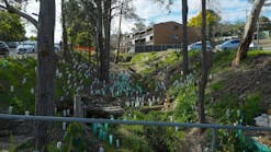
Chapin Five fire rehabilitation project: Excelsior strip mulch above site (above) and on-site (below)When the firefighting equipment and retardant-dropping aircraft are finally packed up and hundreds of firefighters head back to their base camps, planning and management of the secondary impacts of the fire’s effects are already underway. One of the most significant impacts is the loss of the vegetative cover on the soil and the increased erosion potential from the winter’s rains and snows on the denuded topography. In severely burned areas, the intensive heat of logs and heavy bushes burning near the ground consumes the litter and humus found in a normal forest environment. The intense heat vaporizes organic resins found in the woody materials, causing them to migrate into the soil where they form a waxlike layer just under the surface. This process turns a healthy soil that absorbs water into a hydrophobic or water-repellent soil. The result is an increase in surface runoff that can lead to greater erosion. Without proper management, lands already damaged by the fire are extremely susceptible to erosion.Similar to many of the western national parks and forests that experienced fires during the summer of 2000, Mesa Verde National Park, located in southwestern Colorado, faced the challenge of stabilizing hillsides, trails, roads, and watersheds after two fires burned nearly 50% of the park. But, unlike other national parks, Mesa Verde faced an additional challenge: protecting hundreds of archaeological sites scattered throughout the park.Dedicated to People Then and NowMesa Verde is unique because it is the only national park established to preserve both ancient, manmade resources and natural resources. The extensive archaeological record of the park covers a period of human development from AD 600 to 1300. During this period, a flourishing civilization grew and developed, culminating in the construction of elaborate stone villages in the sheltered alcoves of Mesa Verde’s canyon walls. These complex stone villages are the familiar cliff dwellings that include Balcony House, Cliff Palace, and Spruce Tree House. In the late 1200s, these extensive dwelling structures were inexplicably abandoned by their inhabitants. In the late 1800s, local ranchers searching for lost cattle stumbled upon the ancient dwellings. The archaeological treasures located at Mesa Verde are some of the most significant and well-preserved sites in the United States. The park itself was established by an Act of Congress on June 29, 1906, and was designated a World Heritage Site on September 6, 1978. Today, 24 Native American tribes have an ancestral affiliation with the archaeological sites of Mesa Verde. The park consists of 52,121 ac., including both federal and nonfederal lands; had an annual budget of $4,083,000 in fiscal year 1999; and is visited annually by more than 650,000 visitors.According to Jane Anderson, acting implementation leader for the Bircher/Pony Wild Fire Rehabilitation at Mesa Verde, erosion control activities are a regular part of the park’s overall maintenance program. “When we’re looking at erosion factors, it has to do with the roads or trails, usually with stuff that’s falling down on the road. We have in the past years addressed those through federal highways, with engineers and hydrologists who can take a look to see what could we do to prevent that kind of debris from coming down on the road. We have a closed backcountry, but we do have six or eight trails that are open to the public, so erosion control issues are addressed there by our trails crew when work needs to be done.”Anderson was involved in a project to evaluate the condition of some of the cliff dwellings located in the backcountry areas of the park. “The Save America’s Treasures Project that started this summer [2000] was geared toward evaluating the condition of the cliff dwellings in places that hadn’t been visited in as much as 70 years. We were trying to visit those sites to determine their condition and make recommendations of what would need to be done. It might be erosion control, stabilization of architecture falling down, hazardous fuels, or too much vegetation growing into the site that, if there was a fire, could damage the site.”The passing of a summer thunderstorm can change priorities instantly. In the early afternoon of July 20, 2000, a lightning strike triggered the Bircher fire that consumed in excess of 23,600 ac. and took more than nine days before it was fully contained at a cost of $5.3 million. Firefighters were in the process of demobilizing when a second lightning-caused fire, the Pony fire, erupted midmorning on August 2, burning an additional 5,240 ac. and adding $2.3 million in firefighting costs. The Pony fire was finally contained on August 11, but not before it damaged historical structures on the Ute Mountain Ute Reservation. Both fires caused extensive damage to park infrastructure, including roadway systems, visitor facilities, and watersheds. More significantly, the destruction of vegetative cover exposed hundreds of documented and undocumented archaeological sites throughout the park.Enter the BAER TeamChapin Five fire rehab project: Excelsior silt-log grade stabilizer to minimize downcuttingWhile the flames are still being suppressed, the massive recovery effort begins. Known as burned-area emergency rehabilitation (BAER), this approach brings together teams of specialists in soil, water, engineering, biology, and other areas as needed to begin developing a long-range plan for stabilizing the burn areas and preventing erosion. According to the National Park Service, BAER fits into a sequence of postfire recovery actions. BAER planning often begins during the fire, and treatments are done just after the fire to repair damage caused by the fire itself.BAER teams identify resources downstream from water-repellent areas and prescribe emergency treatments to protect those resources. The top priority is to protect lives, private property, and critical facilities such as public water supplies. The next priority is infrastructure or other facilities such as culverts, roads, and ditches, as well as habitat for endangered species, soil productivity, water quality, and cultural sites.Chapin Five fire rehab project: Large-scale watershed treatment using excelsior strip mulchBAER planning involves four steps: (1) Aerial mapping identifies probable severely burned areas and field surveys verify severely burned areas with water-repellent soils. (2) The BAER team then maps these areas and analyzes storm flows to assess flood risks to critical values before developing treatment prescriptions. (3) The team reviews and updates prescriptions as field conditions change or as new information becomes available, then (4) prepares a report identifying and requesting funds to implement the treatment prescriptions.In Mesa Verde, the impact on the cultural resources from erosion resulting from fires can be potentially severe. Anderson reports that 90% of the area burned was reduced to ashes, creating hydrophobic soils. “In watersheds and on slopes, a fire just brings debris down that can silt in sites or it can undermine walls in the alcove sites and the cliff dwellings,” she states. “It can change the pattern of the runoff so that the water might cling to the walls of the alcoves, run into the backside of the alcove, stain the walls, and undermine architecture that’s in there. There’s no vegetation above the alcove site to prevent that water from coming in. The recommendation was made to do some fuel removal, which we’ve been doing over the past few years in areas of high vegetation where there are structures like our research facility or historic buildings. Just last fall, we removed a lot of fuel from in front of Spruce Tree House, a major cliff dwelling.”One of the ways that the park balances the fire suppression activity against preservation of the archaeological resources occurs on the fire line itself. A trained archaeologist is assigned to work with the firefighters on the line and will assist in digging fire lines. But because of their knowledge, the archaeologists can make in-field recommendations that minimize damage to various resources. “They can say, OThis is a place where it looks like we’ve got some ancestral ruins or a wall line,'” Anderson points out. “They can redirect that fire line minimally to maximally protect that resource.”Erosion ControlsOne of the most successful techniques that the park used to control erosion throughout the site was excelsior mulching, which consists of ground-up aspen in a photodegradable matting. The matting comes in big rolls laid out in horizontal strips spaced 4-5 ft. apart across the watershed. The mats slow down the runoff of the water, causing the runoff to drop any sediment on those mats rather than washing it down the hill or into the archaeological sites. Another successful technique involved the use of diverters, usually just logs, laid at the top of the watershed to divert the water around sensitive resources. “We use silt logs, which is just excelsior matting rolled up like a little sausage casing,” reports Anderson. “Those are used much like diverter logs to stabilize areas where we’re trying to get the water to slow down and not take out so much material.”A major tunnel located along the 25-mi. main road required special attention. “Everything above it was burned over,” she recalls. “When that material started to come downhill, it would pool in the road. At the base of that tunnel, they put jersey barriers, the large concrete barriers seen on roadways. They go out regularly and clean those out because they’re trying to divert that runoff so that it doesn’t land right in the middle of the park road.”Longer-term planning includes reseeding the burned areas during the fall. “A lot of that has to do with preventing the invasion of noxious weeds like musk and Canada thistle. We discovered in the Chapin Five fire [in 1996] that reseeding with natural grasses really eliminated a lot of invasion by those thistles if we could get the grasses in early,” Anderson notes.Many of the techniques used to help Mesa Verde National Park recover from the Bircher and Pony fires were the result of the park’s experiences with the Chapin Five fire in 1996. “We learned a lot from that,” she remarks. “We learned techniques that did work, and when we had an assessment of that treatment in ’99, we had the original emergency team come back and they reviewed what we did. They looked at the specifications, went out and assessed our work, and said it was successful. If anything, we might have done a little too much. Now that we have that knowledge, we know how much it will take. We’re in really good shape to move forward with the rehabilitation as soon as we can hire some people to do it.”Despite the efforts, the loss of some cultural resources is inevitable. “Certainly we don’t want to lose any of our cultural resources, and we’re going to do whatever we can,” remarks Anderson. “There might be the situation where there’s nothing that we really can do, so we document what’s left, we have as good of a record as we have, and we have to go on. In the Chapin Five fire, there was a major petroglyph panel that was severely damaged. In consultation with our affiliated tribes, their unanimous feeling was that it was an act of the Creator. There was no human intentional act that set the fire, so it was like this was meant to be and we shouldn’t take extraordinary efforts. They said let it go, so we did. It’s the kind of decision that comes with managing public lands.”Despite all the erosion issues and their impact on the cultural resources, the fires offered an opportunity to increase the level of knowledge relating to the park by uncovering previously undocumented sites. “You burn off all the vegetation, and stuff is easy to see,” Anderson points out. “When everything is under oak brush and service berry, you can walk right by and not see it. When they were doing the hand line, they were finding sites that weren’t on the map. I’m sure there will be a minimum of another 1,000 sites revealed.”
