Using Lane’s Sediment-Water Balance to Understand & Mitigate Stream Instability
Andrew Earles is vice president of Wright Water Engineers, and Andrew Pfeiffer is water resources engineer at Wright Water Engineers. Earles can be reached at [email protected]. Pfeiffer can be reached at [email protected].
undefinedAs development occurs in watersheds, stream corridors rapidly (and often negatively) respond to changing inputs of water and sediment. Failure to manage changes in runoff rates and volumes can lead to incised channels and degraded banks, which contribute to sediment pollution and disconnect the channel from the floodplain. Although the consequences of watershed modification are apparent, the causes are often difficult to isolate. Misapplication of mitigation strategies may exacerbate the channel instabilities those strategies were intended to solve. Here we present the application of Lane’s balance to better understand and mitigate stream instability. Lane’s balance is a simple yet useful conceptual model to connect watershed changes with channel responses and to target appropriate types of solutions.
Lane’s Water-Sediment Balance
Lane’s balance, developed by Emory W. Lane, is a conceptual model for understanding channel equilibrium in relation to water and sediment inputs (Lane, 1954). Lane’s balance is rooted in principles of fluvial geomorphology but has become increasingly adopted in holistic approaches to water resources engineering. The key variables in Lane’s balance are discharge (Qw), channel gradient (S), sediment load (Qs), and sediment size (Ds). These variables are interrelated based on the equation and scale diagram (Figure 1) shown below. Note that Lane’s paper did not present the scale diagram; instead, others have developed the diagram as a useful visualization of Lane’s principles.
Qw∙S ∝ Qs∙Ds Lane’s Equation
Additional terms key to using Lane’s balance are degradation and aggradation. Degradation refers to a decrease in channel elevation through erosion while aggradation refers to an increase in channel elevation through deposition. When neither aggradation nor degradation is occurring (and sediment size, sediment load, channel gradient and discharge are in balance), the channel is at equilibrium. Small perturbations to any variable can disrupt channel equilibrium. For example, increased discharge tips the scale toward degradation. An increase in sediment discharge or sediment size is required to restore equilibrium. This is logical, as an increased coarse sediment load would impart stability and be more resistant to erosion. Conversely, an increase in sediment load would lead to aggradation. An increase in channel gradient or discharge would be required to transport the sediment and return the channel to equilibrium.
One key limitation of Lane’s balance is that it is not quantitative. Lane’s balance cannot be used to relate the magnitude of inputs to a quantitative estimate of change. Additionally, Lane’s balance does not have a temporal component and cannot be used to assess the timeframe over which changes to channel equilibrium will occur. Finally, Lane’s balance does not address changes in planform or cross section geometry, as the channel can adjust while maintaining its cross-sectional area (USDA, 2007; Wohl, 2014). This limitation presents a challenge in dynamic, meandering river systems. Overall, these limitations do not preclude the use of Lane’s balance but are valuable to consider when applying Lane’s balance to various stream instability scenarios.
Stream Instabilities & Mitigation Strategies
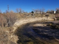
A recent project by the Mile High Flood District (MHFD) and local partners on Cherry Creek in Denver illustrates how Lane’s balance can be applied at a conceptual level to understand causes of stream instability and mitigation strategies. The project location is downstream of the Cherry Creek Reservoir, between East Iliff Avenue and Quebec Street in Denver. Photograph 1 (above) illustrates a representative pre-project reach and shows a severely degraded and incised channel with near vertical banks in 2017. Wright Water Engineers Inc. evaluated the geomorphology and sediment transport characteristics of this reach of Cherry Creek during development of a stream restoration plan for this reach of the creek to assess stream stability.
Based on Lane’s balance, there are four factors that alone or in combination can lead to degradation compared to a historic dynamic equilibrium: increase in discharge (rate or volume), decrease in sediment load, increase in stream slope, or decrease in sediment size. This reach of Cherry Creek is approximately 3 miles downstream of the Cherry Creek Reservoir, which affects several of these variables:
- Water discharge – Cherry Creek Reservoir is a flood control reservoir with modified hydrology relative to historical conditions in terms of increased evaporation and regulation of flood peaks. The greatest changes due to the reservoir operations are related to the magnitude and timing of flows released downstream, rather than to the overall volume of water produced by the watershed. As a part of reservoir operations, flushing flows are released downstream annually. In some years, flushing flows are the highest peak discharges. As a result, the effective discharge that moves sediment through the creek has been altered by the reservoir regulation.
- Sediment load – Relative to the pre-reservoir conditions under which the natural channel of Cherry Creek formed, the presence of the reservoir reduces the sediment load to the creek downstream of the reservoir due to reservoir sedimentation. The sediment regime in Cherry Creek has changed as a result of the reservoir, resulting in a disconnection between the reaches upstream and downstream of the reservoir. Sediment transport occurs locally but is impeded on a watershed-scale, thus shifting Lane’s balance toward degradation.
- Sediment size – The reservoir also affects the size of sediments that are transported to the downstream creek, with coarse sediments retained in the reservoir and relatively finer sediments traveling downstream. The retention of the coarser sediments in the reservoir limits availability of material transported by bedload that could help to armor and stabilize the creek downstream.
All three factors have the potential to shift the needle in Lane’s balance to degradation.
The stream restoration project implemented practices to shift the balance back to a dynamic equilibrium given the modifications to water and sediment regimes caused by the reservoir.
While the stream restoration project cannot change the upstream hydrology or sediment delivery conditions, other variables in Lane’s balance were adjusted, including the following:
- Stream slope – To counter degradation, a common practice is to construct grade control structures to create a milder stream slope. For the Cherry Creek stream restoration project, the incised creek was backfilled to raise the stream invert to provide better connection between the creek and floodplain (to reduce erosive forces). Additionally, a series of riffle grade control structures were constructed to dissipate energy. Each riffle consisted of a gently sloping drop of roughly 12 to 18 inches, resulting in a milder effective stream slope and less erosion potential between the riffles.
- Stream bed material – In conjunction with creating a milder creek slope, the restoration design included additional bed armoring for the riffle drops, consisting of void-filled riprap.
These two features of the restoration design counter the degradational trends induced by the reservoir by decreasing the stream slope and providing coarser material, tilting Lane’s balance back to a new dynamic equilibrium.
Conclusion
In conclusion, Lane’s balance is a simple and useful conceptual model. The Lane framework emphasizes the interrelation of sediment and water within a watershed and how these variables impact channel equilibrium. In this paper, we applied Lane’s balance principles to a stream restoration project example downstream of a reservoir. The channel downstream of the reservoir was experiencing significant incision and degradation due to altered hydrology, sediment transport and sediment size distribution. Restoration effectively targeted slope and sediment gradation to restore equilibrium.
Lane’s balance is a useful initial screening tool as part of a broader geomorphic assessment. Notably, Lane’s balance can be used to guide the fit between the type of issue a channel is experiencing and the types of mitigation measures. Although Lane’s balance is neither quantitative nor temporal, it serves as a useful starting point for further analysis. Watersheds are connected to reaches of stream, and both elements of a system must be managed to preserve and restore valuable stream corridors.
References
• Lane, E.W. 1954. The Importance of Fluvial Morphology in Hydraulic Engineering. Hydraulic Laboratory Report No. 372. United States Department of the Interior, Bureau of Reclamation. Denver, CO.
• Rosgen, D. 1996. Applied Fluvial Morphology. Wildland Hydrology Books, Pagosa Springs, CO.
• United States Department of Agriculture - Natural Resources Conservation Service. 2007. Part 654 Stream Restoration Design, Natural Engineering Handbook. Chapter 13 Sediment Impact Assessments.
• Wohl, E. 2014. Rivers in the Landscape: Science and Management. Wiley Blackwell.


