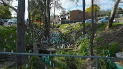
Estimating Erosion Rates with Common Buttonbush: An Application to Lewisville Lake, Texas
A recent study explored the capability of common buttonbush (Cephalanthus occidentalis L.) to withstand and mark erosion along a segment of shoreline at Lewisville Lake in North Central Texas. The study was conducted to better understand erosion rates near the back of the shore, which contributes unwanted sediment to the reservoir. Some forms of hardy, natural vegetation can bind soil while potentially serving as erosion markers.
More than 57,000 large dams have profoundly altered landscapes, society, and ecosystems worldwide. While impounded reservoirs provide many benefits, such as water supply and flood control, they also displace people and inundate terres-trial ecosystems, interrupt boat and fish navigation, lose water through seepage and evaporation, and trap sediment that would otherwise replenish downstream areas. Trapped sediment also takes up storage, and eventually, accumulated sediment may require costly dredging operations.
It is well established that streams supply large amounts of sediment to impounded reservoirs. However, other sources of sediment, such as wave erosion of shore areas, also deplete water storage capacity. Loose sediment such as sand, and poorly consolidated earth material in general, are especially vulnerable to wave erosion at shorelines. Estimating rates of denudation near shorelines can help lake managers assess the need for mitigation measures, such as planting shrubs or laying rocks.
Background
Common buttonbush is a shrub that typically blooms from June through September and produces fruit in September and October. Mature buttonbush typically grows up to 3 meters tall, but can reach heights of 6 meters.[3,4]
Often found in floodplains and riparian zones, buttonbush naturally occupies parts of southeastern Canada and the eastern United States, extending westward to eastern Texas, Oklahoma, Kansas, Iowa, Wisconsin, and Michigan.2,4 Scattered populations of buttonbush are also found in Arizona, New Mexico, southern California, and northern Mexico.
Buttonbush has no serious insect, pest or disease problems.[4] It grows in various kinds of soil, thriving in moist conditions, poor drainage, and standing water.2,3,5 Often buttonbush is used to develop and restore wetlands, control erosion in riparian areas, and create wildlife habitat.[4] Along shores, buttonbush can form dense stands, and its swollen base stabilizes the plant.[3]
STUDY AREA & METHODS
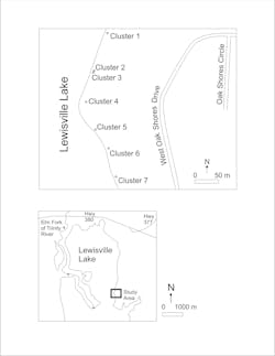
Seven buttonbush clusters containing a total of 55 shrubs were evaluated along a 300-meter stretch of shoreline near the northern edge ofLewisville Lake in north- central Texas (FIG. 1). This large, multi-use reservoir is impounded by an earthen dam located approximately 16 km SSE of the study area. The lake supplies water to local municipalities and also provides for flood control and various forms of recreation. Its normal (conservation pool) elevation is 159.15 meters, creating a surface area of 9421.1 hectares with 375 kilometers of shoreline.6 Evaporative losses are high, averaging 140 cm/year, whereas precipitation averages only 88 cm/year.[7] Several ephemeral streams supply runoff to the lake. The Elm Fork of the Trinity River, fed by water from another reservoir upstream of the study area, is a major tributary to Lewisville Lake.
The study area has a humid subtropical climate, with hot summers and mild winters. In a typical year, air temperatures exceed 37-degrees Celsius and fall below 0-degrees Celsius on several days in summer and winter, respectively. Spring usually brings more rainfall and flooding, followed by occasional droughts in the summer. Buttonbush in the study area is hardy, surviving not only extreme weather variations and wave energy, but often indiscriminate pruning from adjacent land owners. A promontory located approximately 900 meters south of the study area offers some protection from SSE winds (FIG. 1). This promontory suffers extreme erosion and has been stabilized with boulders trucked in from external sources. However, based upon its orientation, the study area is relatively vulnerable to NNW winds. A smaller promontory within the study area, more densely treed than surrounding areas, provides some protection from wind for Cluster 5.
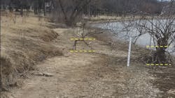
Beneath the study area, the Woodbine Formation consists of ferruginous sand, sandstone, clay, and shale, with scattered and discontinuous seams of lignite, gypsum, and volcanic ash, deposited in a deltaic setting.8 In the study area, it consists mainly of poorly-cemented sandstone and clay. The overlying terrace, ranging from absent to about one meter thick, consists mainly of sand, gravel, and clay. Soil has formed and remains intact (but is eroding) on terrace deposits at the back of the shore (FIG. 2 & 3). Wave action has eroded sand from the Woodbine and terrace formations; this reworked sand is prevalent on the surface and around buttonbush, which is anchored into more compact sand and clay at depth.
The seven clusters were photographed and measured on February 16, 21, and 26 of 2022. During this time, lake level was approximately 0.6 meters below conservation pool, and the buttonbush was accessible and dormant. Shore elevation at the base of the plants ranged from approximately 159.2 meters to 159.5 meters and did not observably change during the study period. Except during prolonged drought, the lake tends to rise above and fall below the plants each year, frequently exposing them to wind and wave energy. A caliper was used to measure the largest diameter trunk of each plant near ground level. An ordinary least squares regression of age and diameter, based upon 10 observations of annual growth rings in cut limbs, was used to estimate the age of each shrub. A steel tape measure was used to estimate the amount of vertical erosion (denudation), by measuring the distance from ground level to the highest exposed root at each plant. Denudation divided by age gave an estimate of the average erosion rate at each plant over its lifetime.
Results
For the entire assemblage, plant heights ranged from approximately 0.8 meters to 3.4 meters. All but five plants showed evidence of pruning. Of the plants pruned, eight had been lopped off near ground level in the past, but continued growing. Approximate diameters ranged from 2 centimeters to 16 centimeters and aver- aged 7.6 centimeters (TABLE 1). The young- est plant was an estimated at 6 years old, and the oldest plant was 25 years old. Average age of plants in the assemblage was 13 years.
Denudation ranged from -6 centimeters to 65 centimeters, averaging 16 centi- meters, and was observed at all but six plants in the assemblage (TABLE 1). Of the six locations not denuded, one showed
6 centimeter of aggradation (-6 cm of denudation), and the remaining five showed no denudation or aggradation. Loose sand occupied all six locations not denuded; apparently, erosion and deposition were approximately equal over the lifetimes of plants at these locations. Half of the plants at locations not denuded were in Cluster 5, protected against strong northwesterly winds by the treed promontory.
Overall, estimated erosion rates ranged from -1 cm/yr to 4 cm/year and averaged 1 cm/year (TABLE 1). Relatively high erosion rates, up to 4 cm/year, were observed in Cluster 6 (FIG. 3). Two of the three locations in Cluster 6 experienced heavy erosion; a third plant growing in the eroding terrace at the back of the shore showed less erosion (FIG. 3). Relatively sparse cover in Cluster 6 makes individual plants more vulnerable to erosion, as there is little opportunity for upwind canopy to slow wave energy. Still, individual plants in Cluster 6 showed remarkable capability to survive despite substantial root exposure (FIG. 3).
This study has important implications for shoreline stabilization. Overall, erosion rates are modest in the study area, but relatively high in Cluster 6. Planting additional buttonbush in Cluster 6, including the shore and adjacent terrace, would likely stabilize the soil by creating more binding root mass and canopy buffer. Additional plantings could also bolster other clusters, though initial efforts should focus on Cluster 6. Such plantings would also enhance the capa- bility of each cluster to support various forms of wildlife. Furthermore, adjacent property owners could be better educated about the many ecosystem benefits of buttonbush. While buttonbush often tol- erates lopping, such practices diminish its various benefits for many years to come.
Conclusion
In sum, this study adds to our understand- ing of the many ecosystem services provided by common buttonbush. In addition to its better-known attributes for supporting wildlife, buttonbush has remarkable capability to withstand indiscriminate pruning and wave impact along lake shores. Moreover, buttonbush can serve as a useful marker for quantifying sediment displacement rates, which should be useful for designing and prioritizing shoreline stabilization measures.
Results of this study can be used to inform planting strategies to restore habitat along degraded segments of shorelines and estimate erosion rates elsewhere along Lewisville Lake. The study identified topography where buttonbush tends to flourish despite heavy wave erosion; simi- lar elevations should be used in planting efforts at the lake. Protocols used in this study could be used elsewhere at Lewisville Lake and in other study areas to estimate erosion rates and lake sedimentation.
REFERENCES
1. Saint-Laurent, D., Touileb, B.N., Saucet, J-P., Whalen, A., Gagnon, B., and Nzakimuena, T. "Effects of simulated water level management on shore erosion rates. Case study: Baskatong Reservoir, Quebec, Canada," Canadian Journal of Civil Engineering, 28, no. 3 (2021): 482-495.
2. LBJWC (Lady Bird Johnson Wildflower Center), "Plant Database," 2021, https:// www.wildflower.org/plants/result. php?id_plant=ceoc2.
3.Wennerberg, S., "Common Buttonbush (Cephalanthus occidentalis L.)," Natural Resources Conservation Service, United States Department of Agriculture, 2004, https://plants.usda.gov/DocumentLibrary/ plantguide/pdf/pg_ceoc2.pdf.
4. Polomski, R.F. and Feder, B.H., "Common Buttonbush. Factsheet HGIC 1098," Clemson Cooperative Extension, Clemson University, 2020, https://hgic.clemson.edu/factsheet/ common-buttonbush/.
5. Donovan, L.A., McLeod, K.W., Sherrod, K.C., and Stumpff, N.J., "Response of woody swamp seedlings to flooding and increased water temperatures, I. Growth, biomass, and survivorship," American Journal of Botany, 75, no. 8 (1988): 1181-1190.
6. USACE (U.S. Army Corps of Engineers). "Welcome to Lewisville Lake," 2022, https:// www.swf-wc.usace.army.mil/lewisville/.
7. TWDB (Texas Water Development Board), "Lake Evaporation and Precipitation," 2022, https://waterdatafortexas.org/ lake-evaporation-rainfall.
Paul Hudak is a professor in the Department of Geography and the Environment at the University of North Texas. Hudak can be reached at hudak@unt.edu.
Paul Hudak
Paul F. Hudak is a professor in the Department of Geography and the Environment at the University of North Texas. Hudak can be reached at hudak@unt.edu.
