November 8, 2018, 2:30 PM: I pulled out of the Chevron station behind two National Park Service firefighting trucks. No big deal—I figured they were headed to the Hill Fire burning west down the freeway. By the time I turned into my driveway five minutes later, a plume of dirty brown smoke was visible in the sky to the east. By 10:30 that evening, I was gone.
Fanned by gusting Santa Ana winds, the Woolsey Fire took off, burning 96,949 acres at what firefighters call the urban-wildland interface, the demarcation line where suburbs like mine abut wild land, and caused the evacuation of more than 200,000 people. The flames started in the Simi Hills grasslands, jumped Highway 101, and roared into Malibu through the steep drought-dry chaparral of the Santa Monica Mountains.
The fire burned more than 40% of the undeveloped land in its path, much of it parkland, resulting in a loss of critical habitat for everything from cougars to amphibians. The flames destroyed cultural resources that offered a window into the history of the area including Paramount Ranch, a western movie set dating to the late 1920s, left recreational trails to slump and slide, and exposed Chumash archeological sites to erosion and sedimentation.
A substantial part of the undeveloped land falls within the Santa Monica Mountains National Recreation Area (RA), the largest urban park in the country, managed by a patchwork of agencies that includes the Santa Monica Mountains Conservancy (with 3,800 acres within the fire area), the Mountains Recreation Authority (9,530 acres), California Department of Parks and Recreation (State Parks, 10,334 acres), and the National Park Service (NPS, 20,472 acres in the burn perimeter).
The BAER Team
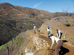
As is usual when an event of this magnitude occurs on federal land, a Burned Area Emergency Response (BAER) team was called in to assess the damage; identify immediate risks to life, property, and resources; and recommend emergency stabilization strategies. Although the team modeled projected sediment accumulation and the potential for debris flows under a variety of precipitation events, in an undeveloped landscape this large, the viability of applying traditional erosion control strategies was minimal. Instead, NPS opted for point protection. Except for one building, the entire western set at Paramount Ranch was destroyed, leaving behind toxic debris. To protect a stream that runs through the area, straw bales were situated to redirect toxic runoff. Likewise, straw bales were used in other areas of the park to divert sediment away from pools critical to the survival of the endangered red-legged frog. Field crews identified an area at a trailhead in Malibu where there was need for hilltop protection and an adjacent road at risk of being impacted by slope erosion and sedimentation. The report called for placing jute matting immediately above the trail and road. To improve the road surface and hillslope drainage, recommendations called for a new swale to be constructed to connect with one already in place.
Emergency stabilization recommendations for Native American archeological resources located on or below steep slopes that were at risk for increased runoff and/or surface erosion from heavy precipitation included straw wattles and sandbags or both to redirect flow away from the sites. Where sheet wash erosion was a concern, the report suggested jute netting or scattering dead vegetation and woody debris to protect surface soils and artifacts. In also suggested that in some cases, fire-killed trees should be removed to help with water diversion. The use of erosion pins (10- to 12-inch nails with washers that are placed in the ground; measurements are taken between the washers and the nail head as the soil erodes) was recommended to monitor surface soil loss. The report also recommended storm patrols, wherein NPS personnel would patrol the approximately 20 miles of roads in the RA before and after storm events to clean out culverts and clear roads and stream crossings. The patrols would also check park buildings, water supply facilities, and flood diversion structures.
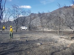
December 2018: Firefighters managed to stop the Woolsey Fire behind a line of houses that backs up to open space one street north of where I live. Two weeks later I went out to see what the fire left behind. I found myself in an empty, mute world. The soil was black around the charred skeletons of brush. Oak trees that had been shedding branches because of the drought were now completely gone. The leaves of the oaks still standing in the canyon bottom were curled and brown, and the tree trunks were black with burn scars. The stench of burned soil and vegetation was overwhelming. How would the landscape come back, I wondered, with the soil unprotected from winter rains?
To get an idea of how this might happen, I spoke with two members of the NPS team implementing the BAER report recommendations, fire ecologist Marti Witter and plant ecologist John Tiszler, both of whom were also developing long-term strategies for the burn area.
Protecting Native Plants
Not surprisingly, the report identified loss of ground cover as the most significant factor in potential flooding and sedimentation. The vegetation in the RA is a mix of native species and nonnative invasive species and weeds, the latter the products of ranching and other intrusions. “We define invasive species as a nonnative capable of spreading rapidly and in some way ecologically disruptive,” says Tiszler. “Given an advantage, they’re strong competitors that can displace the natives, and when they come to dominate, they change factors such as fire and nutrient cycles and habitat suitability.” Relative to the burn area, there is also the issue that the shallow-rooted invasives are less effective than the deeper-rooted natives in holding soil.
“In the Santa Monica Mountains, the number of plants we consider invasive is approximately 50,” says Tiszler. “And the number we actually treat, the ones that we think are in some way manageable, is approximately 28.”
“The main thing that we’re concerned about in our soils is that there’s no vegetation, so there’s nothing to intercept rain,” says Witter. “The effects of soil burn severity in chaparral aren’t as severe as in forest systems because we have low organic matter in our soils, including shallow leaf litter levels, which means there’s not a lot of material to burn at high temperatures for very long. But as soon as the vegetation is burned off, soil starts mobilizing. The slopes are so steep that when soil erodes naturally, a lot of it is trapped behind the stems of chaparral plants. Because there’s actually a large amount of loose soil that is stored behind the vegetation, when the stems burn in a wildfire, the soil is released and starts the process of dry ravel where it moves down slopes and accumulates in drainage channels. This is how we get debris flows.
“We’re talking about very steep, unconsolidated soils, which are naturally erodible, which is one of the problems with the high-frequency fires that have become a trend here. The Santa Monica Mountains have been burning in big fires every decade since we’ve been keeping records. When you look at the mountains, you see a smooth carpet of green shrubs. So when we get a fire, it’s a canopy fire where everything is consumed. In terms of maintaining the native vegetation, these more frequent fires are the biggest threat we have. It takes a long time for plants to get large enough to start producing seed and build up a seed bank in the soil and eight to 10 years to get full canopy closure. So if a fire occurs every 10 years rather than every 100 years as would be natural, you’re definitely going to have more erosion and sedimentation.”
“Debris flows are a natural part of what happens after a burn,” says Tiszler. “They can carry away the seed bank and the shrubs that are rooted and re-sprouting. In a natural area, you just have to let it play out. And not everything comes out as a full-scale debris flow.”
“The native vegetation evolved with drought and fire over millions of years,” says Witter. “In early fall, it’s very dry. The structure of the shrubs is akin to kindling you’d use to start a campfire, and all this vegetation is up in the air where it gets plenty of oxygen. In the Woolsey Fire there was almost 100% vegetation mortality, not just the overstory but also the effective ground cover.”
January 2019: The soil is still black, but there are patches of green coming up here and there. From past experience and their location on the hillside and lining the trail, I assume that what I’m seeing is nonnative grasses and mustard. The plants are close to the ground and scattered, still overwhelmed by the black and empty landscape.
“The non-native plants regenerate faster than the natives,” says Witter. “Mustard likes a post-burn environment. The black soil warms up very fast when the sun hits it, and since the native plants germinate slower, there’s no competition for soil or water. Because the annual grasses that are the predominant plants that take over when you lose the native shrubland are extremely shallow rooted, in years of heavy rain like this, you see a lot of soil slips. It’s good to have cover to protect against surface erosion, but the nonnative grasses really don’t hold up the soil. You see all this bright green grass on the slopes and then you see a soil slump.”
The adaptation that allows native plants to recover in a post-fire environment is the ability to re-sprout from underground structures, from seeds stored in the soil that germinate after a fire, or a combination of both. “Virtually everything in our ecosystem comes back from those mechanisms,” says Witter. “Everything that will come back after a fire was there before the fire. It’s an endogenous recovery.” And how long will that take? Three to five years is a good start.
“The chaparral plants that are tapped into water will begin to re-sprout first. If the temperatures are warm enough, they will start re-sprouting within days of the fire. Next are the plants like sage that may start to re-sprout after there has been some rain. Then comes the huge post-fire annual flora that comes up. The plants are very colorful and very extensive, but in two years, they will be gone back to the soil waiting for the next fire.”
Invasive Plant Management
“Invasive plant management for NPS and State Parks has been a long-term effort—surveying for them and locating them and treating them,” says Tiszler. “We don’t survey in the sense that we lay out a grid and systematically walk it. We start out by assessing the known areas, and in the process we have the opportunity to survey other areas. Just getting out where we know there have been problems, we see more of the rest of the environment. So a lot of surveying occurs in the act of treating.
“We don’t treat invasives like mustard and nonnative grasses, because they’re just too ubiquitous. The only reason we might treat them is if we’re trying to protect a specific sensitive plant species or they’re in a habitat we’re very interested in protecting. But otherwise we consider them a naturalized part of the environment, very invasive plants that have disrupted the natural interrelationships and functioning of the ecosystem but are just beyond management. The post-fire concern is that they will spread into the shrublands where they didn’t exist prior to the fire. Everyone enjoys the beautiful green hillsides we’re seeing now, but what you want to see at this point are black hillsides dotted with green. That’s where you’re seeing good native recovery.
“We don’t like to use the word eradicate—you’re never successful at that in a large landscape like this. The goal is suppressing these invasives to a point where they’re not a significant component in an area of concern. At the moment, we’re hoping to split the funds we have available with State Parks so we can work cooperatively on both our lands.”
In evaluating post-fire conditions, crews begin in areas that they have been treating for extended periods of time. “We know many of the areas where these plants have been problematic so we’re hoping our years of treatment have had an effect and we’re not going to see a large post-fire invasive plant response,” says Tiszler. “But it’s unlikely that we’ve killed every one of the species of concern before the fire, and we don’t want to give them an opportunity to re-establish. Next, we look at our sensitive habitat and riparian areas.
“Invasive species tend to be plants that occupy disturbed land. The problem has often been that in the last 30 to 40 years, we’ve seen post-fire conditions that have not been amenable to the native canopy returning. Because the return intervals have been shrinking, this provides an opportunity for invasive plants, and once they establish themselves strongly, it becomes even more difficult for the canopy to return. Although in a lot of invasive plant sites, we’ve gotten things down to a maintenance level where we might visit once a year or two, we anticipate that with the opening of the canopy and the post-fire environment, these plants will expand rapidly since the capacity to set seed quickly is one of their characteristics.”
Once previously treated areas have been visited and assessed, crews can establish control using a standard IPM (integrated pest management) approach, says Tiszler, meaning, in this case, a combination of mechanical treatment and herbicides. “What we do is true for State Parks and just about anyone who does wildland work like this. The challenge with most invasive plants is that simply cutting them doesn’t kill them. And they’re wonderful at re-sprouting from below-ground parts even when we attempt to pull them up. With a fair number of these species, if there’s any little bit of rootstock or rhizome left, they’ll often sprout from that. So, unfortunately, the only way to truly eliminate them is to spray them with a systemic that gets taken down into the roots.”
With herbicides, the earlier the better. Often the protocol calls for first knocking the plants down mechanically with a weed whip or brush cutter to reduce the biomass. “To the extent that we can catch things early, it means less biomass and less spraying,” says Tiszler. “One of the characteristics of these plants is that they have a more responsive capacity, so if we can get ahead of this, the better. There are situations where this can be done entirely mechanically—it depends on the plant and on how loose the soil is. We don’t want to disturb the soil in doing this work because it can stimulate the growth of more weeds. Also, to the extent that natives are re-sprouting, we don’t want to be turning them up.
“After a fire it’s easier to treat in any one area because it has been denuded of natives. The problem is the amount of treatment one has to do is more extensive because of the post-fire conditions. We’re seeking funds for three years of treatment. In a good rain year like this, we should be seeing pretty rapid native vegetation recovery, and once the natives start coming in, the situation becomes complex. We might carry shields so if there’s a native, we can separate the invasive from it or protect the surrounding natives. But that’s difficult. And then if the circumstances get to a point where the natives are just too abundant, we have to think about actually digging up the invasive plants. Or leaving them be and trying to prevent them from going to seed, although that’s not usually very effective.”
February 2019: The mustard is up to my knees. Some of it is blooming. The black soil of the ridges and canyon that was so disconcerting in December is green with invasive grasses. I climb the hill above the canyon, which from a distance looks covered with nonnative grasses. But when I get up close, I find myself in a field of lupine, a whole meadow of natives blooming in a field of the shallow-rooted grass.
Monitoring
The RA has a long-term vegetation and monitoring program in the Santa Monica Mountains and Simi Hills that includes 300 research plots. Each year a team of botanists monitors what’s happening at 100 of these plots. “If a fire burns any of the plots,” says Witter, “we skip back and start reading these right away to see the effects. We measure the number of seedlings that are coming up, what plants are re-sprouting, how much ground cover there is, and how much bare ground.”
The Woolsey Fire burned so much area that botanists have some 211 burned plots to read. “You really have to read them in the spring because that’s their peak growth time. With a coastal sage scrub community, for example, which is drought deciduous and dries up in the summer, you wouldn’t get a good assessment of how much cover there is if you didn’t read it in spring.”
Revegetation
One of the post-fire anticipations of the press and some of the public has been that given the size of the fire, NPS would be replanting extensively in the burn area. But as Tiszler explains, the park doesn’t have the resources in either personnel or plant material to undertake this kind of effort. “We like to use local stock, so we need to collect acorns for our oak revegetation projects, and we like to propagate the sycamores because there are issues with hybridization with plane trees. So we’re really limited to relatively small areas where we can take action, and we’re focusing on where we were doing projects before the fire. These are sites where I had already identified a need and we were working toward revegetation and restoration. The fire has set that back. That’s another effect of California’s five-year drought—there were so many weakened and dead trees pre-fire, and the same applies to recovery. A lot of these trees were so diminished by drought, even with this year’s rainfall, that the question is whether they have the capacity to come back. So I want to focus on the riparian areas and the oak woodlands, and to the extent that the tree canopy has been lost, to try to encourage and assist its regeneration. It’s not something that we can do overnight.”
Tiszler also notes that there have been a number of requests from the public about using seed bombs to get cover on the slopes. “The problem is while the seeds may be native to the western United States, they’re not indigenous to the mountains. And the odds are they wouldn’t survive here. The best thing for promoting a healthy recovery is rain. What we’re looking for is groundwater recharge, and so far we’ve been seeing a precipitation pattern that encourages this. Our concern is that we need from four to five years of this kind of rain. If that happens, the native vegetation will be looking pretty good.”
March 2019: The land behind my subdivision is Simi Hills grassland, and where there is a stream, stands of shrubland. Here, with things greening up, it is easy to breathe a post-fire sigh of relief. Today I decide to go into the mountains. A small stretch of the Backbone Trail that runs through the Santa Monica Mountains has been opened, and I am curious. But a few steps down the trail and I am taken aback in much the same way as the first day I walked into the burned area close to my house.
Before the fire, this mountain trail was protected under a thick canopy of evergreen chaparral shrubs. Today it is completely, embarrassingly denuded and stands out like a scar against the canyon wall. Here and there, there is a clump of green leaves at the soil line adjacent to a charred skeleton. Farther along, I see a patch of black sage, and in another stretch, a small stand of wildflowers, one purple bloom alerting me to their presence. This is the native recovery that John Tiszler speaks about, and in some ways, it is heartening. The stream, which I usually can’t see for the vegetation, is running wide and full below me. But otherwise, the devastation is complete, the overstory and understory burned as Marti Wittier described. “Three to five years” are just words on paper until you see the bare slopes for yourself.
NPS restoration ecologist Joseph Algiers Jr. and Kevin Gaston, director of planning and strategy at Mountains Restoration Trust, one of the other agencies that manages land in the Santa Monica Mountains, also contributed to this article.
WHERE DO THE DOLLARS COME FROM?
The Burned Area Emergency Response (BAER) funding comes from the US Department of Interior’s emergency fire suppression funds. BAER dollars, which are for the first post-fire year, can be followed up with Burned Area Rehabilitation funds, but these are competitive, meaning that the Santa Monica Mountains National Recreation Area will be competing with other national parks that are also recovering from wildfires. Otherwise, it’s up to the park to develop the resources it needs to accomplish longer-term projects such as multi-year invasive plant control, infrastructure rehabilitation, and trail stabilization and maintenance.
PLANT COMMUNITIES
Chaparral. Dominant vegetation in the Santa Monica Mountains, deep-rooted evergreen shrubs, 4 to 12 feet high. Little understory except occasional needle grass or wildflower clusters; 38,507 acres burned.
Coastal Sage Scrub. Occurs on drier sites and at lower elevations, especially south-facing slopes and inland Simi Hills. Often seen in newly eroded areas, where it plays an important role in soil stabilization.
Coast Live Oak Woodland. Evergreen. Occurs on north slopes and in shaded ravines and canyon bottoms. Deep roots reach the water table.
Riparian Woodland. Occurs in canyon and valley bottoms with perennial or intermittent streams; contains the greatest species diversity, with both under- and overstory vegetation; 1,533 acres burned in the Woolsey Fire, one-third of its regional coverage.
Valley Grasslands. Two types: native perennial (with a well-developed root system that can sustain it through summer drought) and nonnative shallow-rooted annual.
According to NPS statistics, 30.2% of the Woolsey Fire burn area has a slope of 0 to 30%, 35.6% has a 30% to 50% slope, and 34.2% has a slope of 50% or higher.
