When I was a kid, I watched my father traipse across several other people’s property to turn the wheel at the head gate to release irrigation water. I worried about that, because some of the boys sat school talked about Old Man Ray and some kind of “shot” that he had for people who trespassed on his property. I pointed this out to my father once; after he was done laughing, he told me not to worry because he had a right of way that allowed him to cross Old Man Ray’s property.
Later, I ran the same route when my mom sent me to the store. I thought I could use my dad’s right of way, too. I found out later that I was the one who should have watched for Old Man Ray. My father’s right of way applied to his water, specifically; it didn’t apply to my short-cutting to get to the store faster.
A right of way is a legal right, agreement, or contract to pass along a specific part or route of a piece of property that belongs to another person, and it often specifies the reason for the use of the owner’s property. In my father’s case, it was agreement with those who owned the parcels of land he had to traverse to get to the main water head gate. And because rights of way can apply exclusively, he could drive his truck up to the head gate, walk, or travel by bicycle or on horseback.
In the US, people use public lands managed by agencies like the Bureau of Land Management or the US Forest Service as a right of access. Right-of-access land use generally has guidelines that apply to the care and respect of government-owned property. These rules may apply, for example, to nesting or spawning times for birds or fish species.
In the countries of Canada, New Zealand, and Australia, Paul Devaney noted in his 2001 publication Rights of Way Management, such public lands are often referred to as Crown Land. Some Northern European countries still recognize the historic concept of freedom to roam. There, a right of way may be more like a right to access in that it might not apply to a specific route or path.
The concept of the right of way (using one person’s land for the benefit of many) is an ancient one. Historians believe that the first example of a government-built road using a right of way was the Royal Road built in 4500 B.C. that connected the Persian Gulf and the Mediterranean Sea. The famous Roman Appian Way, built in 312 B.C., was a right of way consisting of a sophisticated paving technique, considered the standard in road construction for about 2,000 years. This 350-mile highway was a complex feat of engineering that used cemented stone blocks, which have preserved the Appian Way up through the present time.
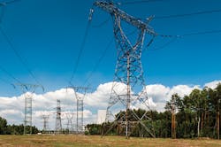
The US has developed rights of way for utilities, canals, and railroads. Easements are examples of private rights of way used by pipelines, long-distance communications, and electric distribution companies for their facilities. In the case of electric companies, however, they are usually classified as “appurtenances” to the land. An appurtenance is considered real property, which sells with the property if it is sold and, unless the contract is drawn up differently, is considered “perpetual;” there’s no expiration date for the utility company. And the owner continues to pay the property taxes.
Rights of Way and the Energy System
The Federal Energy Regulatory Commission (FERC) was established under President Carter with the 1977 Department of Energy Organization Act. It was set up to answer directly to Congress with the mission to provide reliable, efficient, and sustainable energy for utility customers. While FERC primarily regulates electricity, it also regulates the interstate transmission of natural gas, hydropower, and oil.
In 2005, Congress provided FERC with even greater authority for review, approval, and enforcement of mandatory reliability standards for the nation’s bulk-power system with the passage of the Energy Policy Act. To maintain FERC’s mission of reliability (after the major Northeastern Blackout of 2003), the commission approved the Vegetation Management Standard to apply to large interstate transmission facilities, as well as to some lower-voltage facilities if they are deemed “critical to the reliability of the bulk-power system.” Transmission facilities apply generally to lines above 200,000 volts, or 200 kV, while lines below 200 kV are distribution lines and are regulated by the utility regulatory commissions within each state.
“The Energy Policy Act of 2005 gave the commission authority to impose fines of up to $1 million per violation per day for violation of mandatory reliability standards,” says Craig Cano of FERC’s Office External Affairs in Washington DC. “Violations can be uncovered in various ways—a self-report by a company, an audit by NERC [the North American Electric Reliability Corporation, the FERC-authorized organization responsible for enforcement] or one of its sub-regions, or an investigation by the commission.”
He explains, “The exact amount of a fine is governed by guidelines that take various factors into account, such as severity, and did the company self-report? Was the company cooperative in the audit or investigation? The primary goal of the commission’s enforcement efforts is to encourage compliance. To that end, a violator may be ordered to fund a compliance program, such as improved employee training, rather than simply to pay a civil penalty.
“As to process, one path is for NERC to file a Notice of Penalty that often may involve a settlement between NERC and the alleged violator,” continues Cano. “The commission then has 30 days to decide whether to allow the penalty to take effect or be undertaken with further action. If the target opposes the penalty, further proceedings ensue. Another path is for the commission to propose a penalty on its own following an investigation.
“In terms of reliability, there are many mandatory standards for transmission owners,” he adds. “The utility company is bound to those on vegetation management and tree trimming. But the commission does not prescribe how the utility achieves that management. They have a standard for trimming, and it’s mandatory and enforceable. It’s just that FERC does not tell a utility company what their plan needs to be, or can be. Rather, FERC requires that the state or county has requirements for vegetation management, and the utility company must comply.”
For example, the Vegetation Management Standard, FAC-003, sets the minimum clearance between trees and transmission lines in a utility right of way. To achieve the FERC’s goals of service reliability and public safety, the clearance must be maintained at all times. The transmission company may decide for itself what kind of vegetation management it chooses to use—for instance, tree growth regulators, pruning, herbicide programs, or total tree removal. But the specific management for vegetation must “minimize electricity outages from power line contact with trees in, or adjacent to, the transmission line rights of way.”
“Just to be clear, there is no state regulatory or state court involvement in enforcement of the reliability standards,” says Cano. “They are the exclusive jurisdiction of the commission, and any legal challenges to commission orders go to a Federal Appeals Court, generally the DC Circuit Court of Appeals. The standards may require compliance with state or local requirements; however, enforcement of the standards is exclusively under the commission’s authority.”
Why is Vegetation Management So Important?
In the US, utility vegetation management costs the industry from $3 billion to $5 billion annually. Elizaveta Malashenko, deputy executive director for safety and enforcement policy with the California Public Commission, says that, combined, California’s three investor-owned utilities and the municipal utilities are spending over a billion dollars annually just in tree trimming activities.
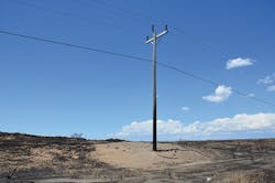
“California has the most stringent vegetation management requirements in the United States. Yet, we still are not able to prevent utility ignited wildfires,” she says.
The California Department of Forestry and Fire Protection (CAL FIRE) is the state’s agency responsible for fire protection in the 31 million acres known as the State Responsibility Areas of California. Additionally, CAL FIRE is in charge of administration of the state’s private and public forests. It also maintains emergency services with 36 of the state’s counties and local governments.
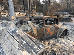
CAL FIRE determined that the state lost over 3.5 million acres during the 2017 and 2018 wildfire seasons. In October 2017 alone, the 245,000 acres that were destroyed cost northern Californians $14.5 billion. During the remainder of the year, more than 9,000 fires cost an additional $18 billion; they burned 1,381,405 acres. The fires that became infamously known as the most destructive fires on California’s records burned 1,893,913 acres.
After extensive investigation, CAL FIRE determined that four of the northern California wildfires in October 2017 were “caused by trees coming into contact with power lines.” The fires, located in Butte and Nevada counties, were the first four investigations completed by CAL FIRE. The department will continue to investigate the other fires and will release those reports as they are completed.
The following is a brief summary of the investigations by CAL FIRE:
- The LaPorte Fire, located in Butte County, destroyed74 structures and burned 8,417 acres. There were no injuries. Although the fire was determined “to be caused by tree branches falling onto Pacific Gas & Electric (PG&E) power lines, no violations of state law related to the cause of the fire.”
- The McCourtney Fire, located in Nevada County, destroyed 13 structures and burned 76 acres; there were no injuries to civilians or firefighters. It was CAL FIRE’s determination that “the fire was caused by a tree falling onto PG&E power lines.” The investigation found evidence that PG&E allegedly failed to remove a tree from the proximity of a power line, a violation of California State Public Resources Code section 4293.
- The Lobo Fire, located in Nevada County, destroyed 47 structures and burned 821 acres. There were no injuries. CAL FIRE’s investigation found evidence that Public Resources Code section 4293, which requires adequate clearance between trees and power lines, was violated.
- The Honey Fire, located in Butte County, burned 76 acres; no structures were destroyed and no injuries were reported. CAL FIRE determined that “the fire was caused by an oak branch contacting PG&E power lines. The investigation found evidence that Public Resources Code 4293 was violated.”
As per regulations, the McCourtney, Lobo, and Honey investigations have been referred to the appropriate county district attorney’s offices. CAL FIRE will investigate the 2018 wildfires and release reports once those investigations are complete.
Out of Spoils Grows an Island
The South Carolina Ports Authority (SCPA) has given new meaning to land preservation under a program that began in 2013. The program set aside close to 1,000 acres under conservation easements. It was all part of the efforts to mitigate impacts of construction at the marine container terminal. The Port of Charleston terminal located at the former naval complex will help boost overall capacity by 50% at the only new container terminal on the US East and Gulf coasts.
The properties in the Cooper River watershed will be permanently protected under the SCPA’s $12 million environmental and community programs. Mitigation of the construction is essential as the SCPA moves toward accepting larger container ships from the newly expanded Panama Canal. The new locks accommodate neo-Panamax vessels—a totally new generation of container ships. Construction of the new Agua Clara Locks expanded the Panama Canal in 2016; by 2018, the Panama Canal Authority reported up to 3,000 additional ships had passed through the expanded canal. The canal went from 42 feet to 60 feet deep, and from 110 feet to 180 feet wide.
The South Carolina Ports Authority set a goal to deepen the Charleston Harbor shipping channel from 45 to 50 feet by 2018 to accommodate the ships.
“I got an urgent call to see if we could clear 20 acres,” says retired 1st Sgt. US Marine Corps Walter Oliver, who owns Oliver’s BushHogging in Beaufort, SC. “They were a month behind because they had lost two excavators in the old spoils there. They were in a real jam and asked how fast we could get it done; we were up here in a couple days.”
EPA and the US Army Corps of Engineers, under Section 102 of the Marine Protection, Research, and Sanctuaries Act, are responsible for monitoring and managing ocean dredged material disposal sites (ODMDSs). The goals of protection and management are to make sure that disposal of material dredged from the ocean doesn’t degrade critical marine ecosystems or jeopardize human health or economic commerce.
“We put all our Gyro-Trac machines on a barge and brought all the machines, equipment, and fuel on the barge,” says Oliver. His company owns three skid-steers with Gyro-Trac’s 500HF cutter heads on them, as well as two Gyro-Trac GT-25 XPs and one GT-35. “Once we got there, we just started working. Into the second day, we were probably three-quarters of the way done.” He says he was happy that they were mulching the overgrown vegetation and could then recycle it to help create a wetland.
Three properties were to be preserved in the historic SCPA plan, including 375 acres of wetlands at the Buck Hall Plantation. Some of the other properties protected under the conservation easements include 122 acres at Brickyard Plantation and 22 acres at the St. James Chapel of Ease in Goose Creek. Property owners all signed conservation easement agreements with the Army Corps of Engineers and the South Carolina Department of Health and Environmental Control. Public space was set aside at Morris Island with 126 acres protected for future generations. A five-year collaboration with EcoHealth Alliance will survey whale migrations, and the South Carolina Oyster Restoration and Enhancement (SCORE) program will help to reestablish 5 miles of oyster reefs.
On Drum Island, the SCPA will create a 22-acre tidal saltwater marsh on a former dredged material disposal site. One of the most unusual characteristics of land preservation at Drum Island is that it wasn’t always an island at all. The harbor/ocean end of Drum Island was a landing point for bridge support pilings for the Arthur Ravenel Jr. Bridge and was used as a spoil, notes Bruce Coy, owner of DCI Marketing Group. A spoil is an area set aside for the purpose of disposing materials dredged from harbor bottoms during deepening projects.
Additionally, the SCPA owns dredge sites at Daniel Island, Morris Island, and Yellow House Creek, off of Cooper River. Coy explains that the spoil on the end of Drum Island was inactive for many years. The 22 acres of thick scrub forest developed there, with a variety of invasive trees, saw palmettos, and other vegetation. The SCPA needed mitigation for the Ports of Charleston and decided to reclaim those 22 acres and return it to natural marsh and wetland.
Drum Island is where the Corps of Engineers and the South Carolina Ports Authority have historically pumped their dredge slurry from the bottom of the shipping channels, as they keep them deep and cleared, Coy says. The Ravenel Bridge connects Charleston and Mt. Pleasant in South Carolina. The cable-stayed, eight-lane bridge is maintained by South Carolina Department of Transportation. The bridge was designed to withstand 300-mile-per-hour hurricane winds—much stronger than the winds Hurricane Hugo brought to South Carolina in 1989.
For some, the idea of working on an island may not sound very inviting, but Oliver takes it all in stride. “Even when we had trouble with one of our machines and it went down, Gyro-Trac was there for us. Being on an island working, you’d think if there’s any problems it’s time consuming, getting things fixed. We have Gyro-Trac’s Nexus Service Platform. It’s all in the machines; we had a couple codes pop up, and with a phone call they were able to clear the codes and we could keep on working. It saves valuable time. You don’t have to keep going back and forth to the mainland.”
Tony Wilson, project manager with L-J Inc. in Columbia, SC, explains that the work on Drum Island included removing the vegetation, construction of the protective revetments, and excavating to remove spoil deposits and redeposit them at the north end of the island.
“We’re in the process of bringing that water level down,” he says. “There’s 8,000 tons of rock that we’ll put in when it’s finished. The rock work will reshape [the island] and protect it from erosion. When we’re done, we’ll have 22 acres of marsh showing.”
The state wanted the site to include marine habitat that would withstand the weather and tide conditions. The Army Corps of Engineers wanted a site assessment to make sure any exposed contaminants didn’t end up being released back into adjacent waters. Under agreements between EPA, the Corps of Engineers, and other agencies, a site management and monitoring plan was developed to address the disposal of dredged material at the Charleston ODMDS.
There is one major canal on Drum Island, notes Wilson. The plan is to create creeks so the tides come in and fill the ditches, but when the tide goes out, it will leave a low marsh area.
Once the wetland is finished on the island, the habitat will be ideal for native plant and animal species. The salt marsh will include a low-lying spartina (spartina alterniflora) marsh, a middle-level marsh, and a vegetated upland area. Tidal ravines that branch off the main island canal will snake through the island and assist with reestablishing the oyster habitat and future shell banks.
Caring for Georgia’s Highways
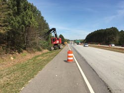
Andrew Dial, owner of Ground Cover Clearing & Final Grade located in Oxford, GA, performs a great deal of work for the Georgia Department of Transportation, including vegetation management and removal along interstate rights of way. Although Dial owns a variety of excavation machines, his favorites are the F Series Caterpillar excavators, like the 323F L and 325F L. “It’s the best tool we have,” he says. “We have all the controls right there. We can dial in for the hydraulics, and they’re just easier to maneuver.” He also uses large mulcher attachments made for excavators from Denis Cimaf Inc., a Canadian manufacturer.
Dial and his foreman Colton Long agree that the terrain in Georgia is challenging. Many of the interstates were built almost 60 years ago. If the topsoil along the right-of-way area gets wet, it doesn’t hold or grip well. “On the interstate, we don’t compromise on safety, and every day we take risks out there,” says Dial.
“You have to really watch the roads and drivers; you have to be defensive,” adds Colton. “We put that ‘Shoulder Closed’ sign out every single day that we’re out there.”
Dial has “words of wisdom” for the public when they approach DOT crews working on the highway—in any state. “For every mile per hour a car increases its speed, it shortens their reaction time. Slow down just five miles an hour, and it would work better for all of us. Just slow down for that tenth of a mile where we’re working. It’s really not that far.”
When the crews are working around Georgia’s waterways, no matter what kind of waterway—stormwater ponds, rivers, or lakes—they must maintain a 25-foot water buffer, and they cannot travel or work with the equipment in those 25 feet.
“That’s one of the ways that every equipment piece has its own purpose,” says Dial. “The excavator has a 30-foot reach. So, we can use that to reach over and get [the vegetation] without getting into that buffer zone.”
He notes, “We do a lot of work where the tree line is right up to the guard rails. We may have tree limbs hanging right over them, and once we get it all cut back, it increases the visibility greatly.”
Most of the work involves clearing the right of way 50 feet from the edge of the pavement and removing dead or diseased trees within the remaining right-of-way limits. The work allows the DOT to maintain and visually inspect roadside slopes that were previously covered with vegetation. It also helps with several aspects of safety—anything from increased visibility to eliminating trees that could be struck by vehicles leaving the roadway. The Insurance Institute for Highway Safety says 20% of vehicle crash deaths occur when vehicles leave the road and strike a fixed object, such as trees, utility poles, or traffic barriers.
Another benefit to clearing vegetation, Colton says, is that when it grows right up to the edge of the guard rails, that seems to make people think it’s okay to throw things out of their vehicles. “There’s a big difference in the areas we’ve cleared. The litter crews can get in there and be more thorough.”
