By the end of the 19th century, Americans were enjoying the benefits of shorter work hours and new technologies. The cultural overhaul included the popularity of outdoor exercise and fresh air, and that sparked the advent of amusement parks, beach bathing, and other outdoor entertainments. Typically situated on lake or ocean shores, with access by special trolley trains, these warm-weather attractions brought crowds away from the urban heat for bathing, refreshments, and eventually amusement rides such as carousels and roller coasters.
While New York’s Coney Island was arguably the era’s paragon of parks, the city of Euclid, OH, just east of Cleveland on the shores of Lake Erie, offered visitors another attraction: Euclid Beach Park. The park came into being through the entrepreneurship of the Humphrey family, which began with a popcorn concession ownership. The Humphreys leveraged their experience and funds to launch the park from a modest venue into a successful operation. By the early 1920s, the beaches had taken a back seat to the lure of other attractions such as the haunted house, a dance hall, a toboggan-style thrill ride, food concessions, and more.
They Really Landed Planes There?
At one point the beach was so extensive that an aerodrome was built. Fliers would bring their craft to the Euclid shores, landing biplanes on the beach and then, with much fanfare, performing aerial gymnastics to amaze the crowd of visitors. Gentle grassy slopes led down to the beach for easy access to wade or watch.
Today, all that remains of the park is the ornate brick and stone arched entryway, restored and dedicated as a Cleveland historic landmark. It is almost unbelievable that 100 years after its peak popularity, the same beach property that served as an airstrip offers barely a few inches of beach—not just at the park, but all along the city’s coastline extending for 4 miles. The broad beaches, crowds of bathers, and daring aviators linger only as ghosts of memory in family folklore and historical photos.
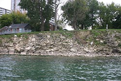
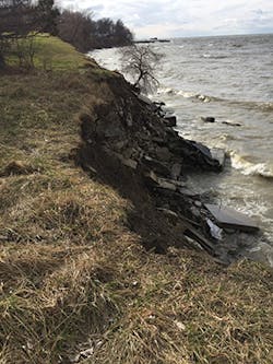
Now, with the shoreline severely eroded, there are no more grassy slopes. With very limited access to the water’s edge, visitors must pick their way over chunks of old cement, rotting wood pier supports, dead trees, and other debris, only to find that no beach exists at all. Euclid Beach is little more than a euphemistic name.
But the good news is that it is all about to change, and in fact, the revitalization is already under way. A shoreline restoration project, whose first phase was the Sims Park pier and trails, promises to be just the revival the City of Euclid needs. Phase 2 began in late 2018, with a big piece of the funding from a surprising source. As the project organizers confirm, “It was a long time in the making.”
The Potential of Location
“Getting people to agree on a plan, especially one with this scope of work, is a huge effort,” says Euclid Mayor Kirsten Holzheimer Gail. The former city council member recounts her successful bid to lead the city into a new era with a firm commitment to maximizing the city’s geographic potential. “Being near Lake Erie is one of our strongest municipal assets,” she says. “We think that quality of life is very important, and access to natural recreation—getting out to enjoy natural beauty in a serene environment—is an essential and healthy pursuit.”
She notes that the city is one of the first “ring suburbs of Cleveland,” settled in the late 1700s and chartered as a city in 1930. “Today we have about 48,000 residents, and Euclid and the water have always been synonymous terms locally, but 10 years ago the area was an unfortunate picture of decline. Area manufacturing had changed, and those jobs and dollars were gone; the recession affected residents, and, with increasing degradation, the beach for all intents and purposes barely exists.”
Despite the city’s proud asset of a Lake Erie shoreline, she explains, the beaches can only be accessed at a few points along the entire coastline within the municipality. Erosion is the primary deterrent.
“Years ago, there were grassy slopes and pathways that easily allowed the public to access the water. Now, only a few steep and treacherous private stairways connect the 20-foot bluffs to the beach areas below.”
Over the decades, the slopes were eaten away, and a spate of stopgap measures by individuals and businesses were inadequate to stop nature’s forces.
“People have been talking about doing something to address this, and up until now it’s really been just pie-in-the-sky ideas. But what we are doing in this multiphase Euclid Waterfront Improvement Plan—and have already done, to the credit of all stakeholders and participants—is going to change the city dramatically,” says Holzheimer Gail.
From Nursing to Nature
With a diverse career in nursing, from emergency room and trauma to helicopter air-rescue expertise, Euclid resident Charlene Mancuso was the just the right person with the savvy, temperament, and patience to bring people together to advance the shoreline improvement concept. As a veteran member of Euclid city council, she has long been a partner in advancing the needed changes.
“When you work in trauma and have a career seasoned with the demands of a complex institutional operation, you become pretty well prepared for the requisite hand-holding needed to work with local communities, worried individuals, and multiple committees,” says Mancuso, recalling her nearly 10 years of participation to make the project reality.
In fact, she remembers that almost two decades ago in 2001, people were running for local office on a “lakefront improvement project” platform.
“I saw that my property, which does front the Lake Erie shoreline, would be affected, so I got involved,” she says. But many years and many failed ideas later, Mancuso was discouraged.
In 2009, the city was in the process of hiring a consulting firm—SmithGroupJJR of Madison, WI—to help design a master plan to address erosion, lake access, and public recreation. Once the preliminary plans were completed, the big hurdle, says Mancuso, “was getting the residents who live on the lake—varying types of property owners, the different homeowner associations, industry, the city, and every stakeholder—to the table to agree on the concepts.”
Mancuso explains that residents and property owners had been hearing about improvements and project ideas for years and made it very clear that unless there was some new compelling reason, “don’t waste my time with another meeting” would be their unanimous response.
Give Us Your Land, and We’ll Fix It for Free (Almost)
To implement the master plan, which included a 3,000-foot shoreline trail, would required the property owners along this pathway to give a land easement to the city to fulfill the project goals.
“If you give us your land, we’ll fix the problems” was the overarching message, but it was hard to convince residents, reports Mancuso. It was a clear juxtaposition of facts and emotional issues. With every severe rainstorm, high wind, and freeze-less lake winter, residents faced unprecedented rates of erosion—but giving up their land and perhaps some privacy? It was a difficult tradeoff.
“People were praying for the lake to freeze over, as this stops the water from continuing to pound the shoreline for another several months,” she explains.
With properties set back on 15- to 20-foot-high bluffs, it was hard to see what was going on below at the water’s edge, but come spring, residents were continually dismayed. She says it became obvious properties were losing 1 to 3 feet or more each year. The toe of the residents’ bluff that took a pounding all winter was further eroded, carving into the vertical wall, with runoff at the top edge also causing soil to loosen.
“Then add in one or two good windstorms that can easily take out the trees at the top of the bluff—which is not only a loss of the tree, but when they fall in they take a huge amount of soil with them—and this exacerbates the problem,” she says.
With picnic tables threatening to fall into Lake Erie, the Euclid waterfront improvements plan promised that in exchange for several feet from each property owner, the problems would be fixed, and fixed for good.
Still, Mancuso says, residents were reluctant.
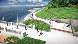
“Yes, the erosion is very real and very severe. While we explained that by giving up a portion of their land as an easement to the city and offering this solution that grooms the bluff, the project with its plan of 3,000-foot boardwalk, pier, marina, and recreational opportunity also provides an essential public access where right now there is practically none.”
But public access means exactly that: The public would be there, walking, enjoying the water, and fishing from the planned pier and marinas. The high bluffs would be reconfigured to be vegetated slopes. “So you can imagine all the responses concerning invasion of privacy and losing control to the city,” she says.
“There’s a very territorial and proprietary feeling about land ownership rights being invaded. We had to convince everyone that this sacrifice was not only going to fix their erosion crisis at no cost to them aside from the easement, it was for the greater good of the community.”
And, she notes, the project could not go forward without a unanimous buy-in for the entire planned shoreline restoration. “You can’t do a stop-and-start restoration; it has to be the entire 3,000 feet, with the terminations at both ends of pier and marina projects.”
Although the city explained that grant money for the project was actually forthcoming, she says credibility with property owners was established with the consistent and constant presence at all meetings of their consulting staff from SmithGroupJJR.
Ten Years to Reality
Jason Stangland, PLA, SmithGroupJJR waterfront practice director and principal partner, invested a decade in the project; he describes the scenario that began in 2009.
“At the onset of the project, the concept was always both to control erosion and stabilize the shoreline, and to optimize access to the lake, which is very limited. We started with a master plan to look at all these aspects and see where we could find opportunities to meet all the needs of the community and the environment.”
Starting with a series of multi-day workshops, Stangland says, the team brought in all the stakeholders to learn what they wanted to do. However, he emphasizes that a critical component of the whole endeavor was the regulatory aspect, and it was crucial that what everyone wanted could be approved to build. “It was the regulatory discussion that really drove this project.”
It was clear at the outset, he says, that from a regulatory and erosion standpoint, “You cannot solve this on a parcel-by-parcel basis. One of the most compelling pieces of the project was the fact that the project is so large and comprehensive and comprises so many committed individual participants.”
The 3,000-foot boardwalk, marina, and piers impressed the regulators. “They saw we had a plan that would encompass the needs of the coast that is so compromised, with a lasting solution that will save the properties, conserve the shoreline by making it better than it has been in nearly a century, and on top of that offer the entire City of Euclid access to this lake. When you improve quality of life and the environment, it is an impressive goal.”
Stangland adds that as of now, “this is the largest lake fill project the State of Ohio has ever permitted.”
Thanks to the contribution of the easements, after nearly two years the plan was finally agreed upon, with residents approving the short- and long-term goals for their land and community.
Engineering Out Erosion
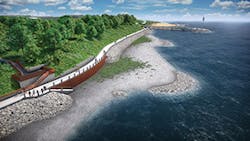
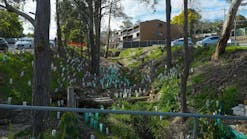
The existing bluffs for the length of the project will be cut back and a slope of 2:1 created, which dramatically alters the profile of the existing shore. Stangland says that using a combination of native vegetation with strong root systems on the slope will keep the soil in place, while the toe of the slope will “be protected in a couple of ways.”
“Mechanically stabilized earth walls will be used, and in some areas, if that isn’t doable, we’ll use a cast-in-place wall. However, the beach will be out in front of this, and we are creating a cobble rather than a sand beach. There is a huge ice-shove impact on the beach, so cobble is a good choice.”
To understand the water better, the team looked at how the waves interact with different lakebed conditions to ultimately construct a beach that has a broad range of stone types and sizes.
“We don’t want it to be a uniform material; it won’t look natural, so we have specified 3/4-to-1-inch range stone that over time will take on a rounded appearance and mix with the sand.”
He says the goal “is to make this pretty maintenance free.”
He adds, “Another important feature is the integration of green infrastructure within the upland portions of the project. This will manage the stormwater at the new Joseph Farrell Pier at Sims Park.”
Removing a large bluff that is currently adjacent to the finished trail will reconfigure the bluff to create a biofiltration area. “With native vegetation, we will create a great filtration basin for the runoff from the upland areas and parking lot, and this will also attract wildlife to this habitat. Our concern here is not water quantity but rather water quality, and biofiltration with the appropriate plants and design features will go a long way to removing harmful contaminants that might otherwise enter the lake.”
SmithGroup engineer Dave Wolmutt says that putting in the cobble beach “in front of the revetment enhances the overall habitat and will get people down to the beaches.”
He notes, “We had to be very sensitive to the Ohio Department of Natural Resources [ODNR], who required restoration to be as natural as possible. There’s a huge amount of old material like concrete rubble, exposed steel rebar, pipes chained together to create a breakwall—you can hardly believe what’s in there, and it all has to go.”
Cleaning up the beach and shore is one thing, but the remediation is much more specific than simply unloading new sand and rock. Wolmutt says that in order to get the proper configuration of stone and breakwater, extensive lab testing was performed.
“We put together a physical model in a large wavetank, about the size of a soccer field, and we created a physical environment to replicate the wave action and its effect on beaches and breakwaters.
“The layout of the beaches is a big issue. Part of our model testing was to configure how the coastal structures are oriented to the wave action so that it allows sediment to bypass. Our coastal engineers did the numerical computer modeling, predicted wave heights, and specified properties such as stone hardness required for freeze-thaw situations,” says Wolmutt.
In the end, Wolmutt reports, ODNR looked at the physical modeling, the test results, and the safety factors and ultimately concurred with the engineering findings.
“One of the breakwaters juts out into the lake for 300 feet, and will be 20 to 25 feet wide. The stones are sized based on the predicted wave height, with the largest being 3 to 5 tons each. Plus, they have to be a certain shape, and they have to be placed in a certain way to hold together. There are agency-approved quarries that we work and others who can provide hardness tests on stone, and from this we can pick the ones that will withstand the rigors of a freeze-thaw environment.”
An Unlikely Source of Funds
Stangland says that one of the critical pieces to gaining participation from residents in going forward with the easements was the demonstration of real money allocation, not just a promise. Nearly $3 million came from an unlikely source, the Federal Emergency Management Agency (FEMA).
“This was something I was familiar with from the agency that we typically think of as the post-disaster assistance resource. However, their pre-disaster mitigation funding is something I had worked with before on Great Lakes shorelines,” he says. “The key to this is to comprehensively tell the story across any of the grants and really convey to them that the group you are working with is fully engaged and committed to the work and the goals.”
He says the agency is concerned about loss of life and replacement costs of structures, and SmithGroupJJR explained that erosion in Euclid was extreme.
“We had to explain the liabilities at stake and explain that as the beaches no longer exist, the bluff responds to this tenuous condition and in a few months additional erosion occurs. By showing FEMA the patterns and demonstrating that assets such as a parking deck lot that supports an 800-unit apartment building on the eastern end of the project is being undermined, they see there is a clear threat to stability.”
There were other examples, Stangland says, demonstrating that the level of erosion “could at any time become the tipping point for a building disaster,” creating circumstances that also fall into the pre-disaster mitigation arena.
The Euclid city council had approved the master plan, and under guidance of SmithGroupJJR the city applied for $2,670,712.50 of FEMA pre-disaster mitigation funding.
Five months later, the planners were congratulated by the Ohio Emergency Management Agency, which said the project had been selected for further review with encouraging comments from the chief of the Ohio Emergency Management Agency: “Many eyes nationally will be on this project because of the size of the funding award and its unique circumstances, and we believe this award gives us an opportunity to leverage these federal funds for additional fundraising.”
Those words were music to both Stangland’s and the mayor’s ears, as the project was intended to serve as a template for municipalities across the US facing similar problems.
A Pioneering Tradeoff
“When we started, the City recognized we would be a pioneer in this effort and a model for other communities that illustrates how diverse partners, regulations, and funding can all come together to create real and significantly meaningful change, and can be shared with others,” notes Allison Lukacsy-Love, AIA, Euclid’s community project manager for the shoreline improvement plan.
“Many people don’t realize that the trail we are putting in follows the shoreline from long ago and used to be a Native American trail that over time became privatized. People tend to accept current circumstances, and few remember that historically there was public access, people could see wildlife, and the beach was at least 40 feet wide,” she says.
Yet, she adds, the improvement plan involves more than restoring public access and native habitat; it also serves as a foundation for economic development. As of mid-2018, the City of Euclid has nearly $5 million in secured funds from federal, state, and county agencies for the western phase 2 construction of the project and continues to seek additional funds from public and private sources based on the commitments of monies already received and allocated.
In addition, a FEMA pre-disaster mitigation award for a significant portion of the western phase 2 construction is currently under contract review. Lukacsy-Love explains that FEMA has certain constraints on when money is disbursed based on finalizing of contract awards.
“This being the case, we split the current phase of the project into a western and eastern portion when we solicited for bids in spring 2018. Phase 1, Sims Pier and Trails, was completed in 2013 and is a demonstration benchmark of commitment. Phase 2 is the current phase, which involves shoreline restoration and recreational trails and includes the 3,000-foot paved, multi-modal trail installation and erosion stabilization. Phase 3 is the marina and the upland work, for which we are still engineering and fundraising.”
Each completed phase builds confidence and commitment, and as the public begins to take advantage of the new opportunities, it becomes a source of regional interest that can only grow over time.
“The more people that can access the shoreline, the better we can promote opportunities for economic development. Our plan for the marina, for example, includes food services and retail shops, and as these enterprises realize financial success with the public who are going to have access to the lake, more investors will see the potential to bring their business to the downtown and lakefront. The project is really acting as a magnet and casting a much wider net beyond the boardwalk and the pier. Water access is a huge draw here for fishing, boating, and safe family recreation; it can only get better over time.”
Bringing a sustainable place-based development to the area is important to connect residents to the local amenities that have been inaccessible for the majority of residents for too long, she says.
“We’re looking at the creation of 3,600 feet of public lakefront access, almost 3,000 feet of a stabilized shoreline, and 5 acres of aquatic and upland habitat that will be an attraction for people to get outdoors and enjoy nature in all seasons,” she says.
Lukacsy-Love envisions approximately 25 full-time jobs being created and an additional 500 to 700 jobs being added to the region upon final project completion.
“And for the 100-plus residents who gave up between 10 and 20 feet of private property to new public space, the shoreline stabilization and erosion mitigation alone is going to take a huge weight off their mind, as they are each currently losing at least a foot a year. In a few decades, without proper revetments and shoreline protection, that area would have been gone to natural forces. So they are real winners in this.
“Now they will have a stabilized property, and this is going to raise their property value in the long term, which directly improves the financial health of the city through a tax increment financing district designation in the project area.”
Lukacsy-Love further commends Stangland and the SmithGroupJJR team who kept the momentum going by ensuring regulatory permits and requirements were met in tandem with the stakeholders’ approval.
“No sense in having people love a project that can’t be approved or permitted,” she says. Timely approvals reassured the residents, helped with the funding sources, and generally kept up the optimism and enthusiasm.
Gaining Consensus
Making all the decisions publicly available was another goal of transparency by SmithGroup, and one well appreciated by property owners. Euclid homeowner association president Paul Roba says, “They did a nice job in being transparent. There were no secrets, and everyone could access and read all the documents. We had an attorney review them to make sure we were protecting ourselves, but after all the false starts over the years, this is a vision coming to reality.
“I would tell anyone who is looking at this type of collaboration to be as open as possible. Keep the flow of communication often and consistent. Meet face to face as much as you can. Talking to people one on one and really listening to their concerns is how you tackle the objections to going forward. Make sure you understand what people are really saying and document everything in minutes so you don’t have to rely on memory for your facts.”
Mancuso could not agree more. “I spent years meeting with people, and it’s amazing what people say in a meeting in a group and what they say over a cup of coffee one on one. You really learn what their concerns are. In this case, safety and security was a big issue. Residents wanted the assurance that with the increased public access and changes from a bluff to a slope, their properties would be protected.
“When we brought these concerns to council meetings, part of the allocated budget included security cameras and other safety measures at the entrances and along the pathway. So this one issue, which could have been an impediment, was easily solved and went a long way to reassure the residents in their easement decision-making,” says Mancuso.
Mayor Holzheimer Gail sums up what “has truly been a team effort.”
“We worked hard to do this, to take a positive approach and build on our assets, and the lake is a great one. There were a lot of naysayers, but by finishing the pier and doing this step by step, people are really getting excited and ready to commit. We’re in good shape with our permits, we have our bids; in essence, we’re shovel-ready for the next phase.
“I really believe this is going to be a game changer and is going to spur positive growth and investment. Already we’re getting calls from other people—‘Hey can you do this in my area? Our erosion is a crisis’—so I know we’re coming down the other side of the mountain at this point. And even more than what it does for us in the immediate sense, for Euclid, is that we are planning to connect to a whole host of other state and county park projects with our trails and greenways.
“This multiphase project is the beginning of becoming a part of a larger network that is establishing a sense of place and connectibility. We’re saving our shoreline and creating a new, exciting, and accessible Lake Erie environment. It can really make a difference.”
According to the City of Euclid, the overview of the 2009 waterfront improvements plan was a $30 million vision that would be implemented in phases. In 2013, the Sims Park fishing pier and trails was completed as phase 1, and in late 2018, phase 2—the shoreline enhancement component—broke ground.
The plan describes this ambitious effort: “It is a transformative project that promotes economic development and private investment, expands habitat, provides public access along a stabilized shoreline, cleans stormwater prior to entering the lake, removes approximately 40,000 tons of debris and rubble littering the nearshore area, and builds nearly 3,000 feet of lakefront trail.”
