Sometimes a project requires keeping sediment out of clean water that needs to remain free-flowing. Sometimes it’s not the sediment that has to be held back, but the water itself, so that work can be done in the temporarily dry space.
When the project has either of those requirements, then a pair of special tools does the job. Cofferdams and turbidity curtains are simple to understand, but powerful in how much easier they make certain types of erosion control projects and how much they protect water quality.
Eel River
Cofferdams made by Aqua Dam of Scotia, CA, played an essential role in a bridge repair project on the Eel River in northern California. The work started in June 2016 and finished early that October.
The Holmes Larabee Bridge spans the Eel River near the town of Holmes, in Humboldt County. Pacific Lumber Company built this bridge in 1937 and sold it to Humboldt County in 1959.
Just 10 feet wide, the one-lane bridge is a low water crossing, used mainly by nearby residents. It is open for use only from late spring through early fall, before heavy rains often cause the river to rise above it.
The bridge was built of wooden timbers that had rotted over the years. It had to be closed to all traffic until it could be repaired.
“We provided temporary support to hold the bridge for the next five to 10 years,” says Mark Benzinger, vice president of Mercer-Fraser. This Eureka, CA, construction firm rehabilitated the Holmes Larabee Bridge for the county. Mercer-Fraser specializes in infrastructure and other public works projects.
“We removed the rotten timbers, we cut off the rotten piles, we removed the pile caps, and we spliced in new section of piles and replaced the pile caps and miscellaneous bolts,” explains Benzinger.
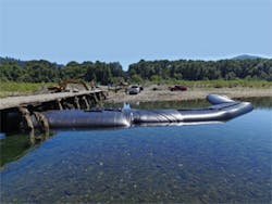
Cofferdams were used for the sections of the bridge where excavation had to be done. Three sizes of Aqua Dam were needed, arranged roughly in a U shape, to hold back the Eel River and keep the work area dry.
The project required 60 feet of the 6-foot-tall Aqua Dam for the main section. The upstream side used 122 feet of the 4-foot-tall dam. The downstream side took 60 feet of the 3-foot-tall dam.
The 6-foot-tall Aqua Dam had custom-size collars to fit the smaller 3- and 4-foot-tall dams. The shorter Aqua Dams started on top of the 6-foot cofferdam and ran to shore, forming the upstream and downstream legs surrounding the work site.
The 6-foot-tall dam section had to be squeezed up against timber pilings on both sides, but no damage was caused to either the Aqua Dam or the pilings. It was used in the deepest area that required excavation.
Installing all of the dams took only a day. Removing them required about the same amount of time.
With no rain, the deepest part of the Eel River was only 6 feet. The gravel lying atop the riverbed meant no dirt would be disturbed when timbers were removed, so it wasn’t necessary to extend the dams all the way to the far shore.
Benzinger, who had seen Aqua Dams used on other projects, says that on this project the dams “worked quite well.” Timing was a big challenge to the project. “We had to get everything done before the water would rise [with the onset of fall rainy weather],” he notes. Fortunately, the weather was “really nice, perfect for working—hot and dry.”
The age of the bridge brought its own challenge. “Any time you’re dealing with old structures there are lots of unknowns,” he adds.
To remove the old timbers and other debris from the site, an excavator was stationed on an adjoining section of the bridge. Its operator lowered a bucket over the side so workers could put used material inside for convenient collection and later hauling to a dumpster.
Wildlife posed no problems during the project, but before work could begin, all fish nearby in the Eel River had to be safely removed and relocated beyond the site. A California Fish and Wildlife biologist was present to supervise this preliminary step.
Niangua River
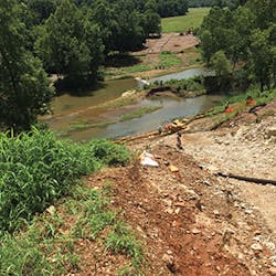
Several states east of the Eel River lies the Niangua River. A tributary of the Osage River, it flows for 125 miles through central and southern Missouri. Part of the larger Mississippi River watershed, the Niangua is popular for water recreation including fishing, kayaking, canoeing, and white-water rafting.
An interesting pipeline replacement project took place on the Niangua from July until late November 2016. The work site for the project is about 5 miles east of Buffalo, MO, and 30 miles north of Springfield, MO.
The land on both sides of the river is owned by the same farmer, which made the operation a bit easier. The work itself was nowhere near as easy.
The crew dealt with installing 900 feet of pipeline (including 350 feet across the width of the river); blasting through solid rock, and working within 70-foot rise uphill, white-water rapids, and a flood zone. And then there were the copperheads to avoid—lots of them.
“It was a tough job,” says Ladie Durkin, construction superintendent for Minnesota Limited of Big Lake, MN. He describes the sheer rock hill as having “a slope of 45 degrees or sharper.”
Founded in 1966, Minnesota Limited is one of the largest construction firms in the central US. The company specializes in pipeline installation and replacement and related facility construction in the energy field.
The job on the Niangua River involved replacing worn-out pipes carrying crude oil for Enbridge Pipeline of Edmonton, AB, Canada. The new pipeline is 22 inches in diameter.
Pipeline was installed across the Niangua River.
“We integrated a smart tool throughout the pipeline. It has magnets that tell the thickness of the pipe,” explains Durkin. If corrosion thins a spot of the new pipeline, GPS can locate it precisely. Then only that section of pipe will have to be uncovered and spot-welded, saving both time and expense.
In addition to replacing the worn out 22-inch diameter pipeline, the project cut back and removed an even older 10-inch-diameter pipeline for 50 feet on either side of the river for safety reasons. It had been laid shallowly enough that kayaks sometimes got caught on it. “You could see the marks where the kayaks had hit it,” says Durkin.
Cofferdams were essential for providing dry work area for removing the old pipelines and installing the new one. Minnesota Limited relied on cofferdams from Dam-It Dams of Grand Blanc, MI.
“We put a Dam-It Dam upstream and another one downstream to divert the river,” says Durkin. The upstream dam was 250 feet long, 8 feet tall, and 24 feet wide. The downstream dam measured 225 feet long, 6 feet tall, and 18 feet wide. The dams were about 300 feet apart. Pumping the river water into them and doing the rest of the installation took only a couple of days. Removal went more quickly.
Depth of the Niangua River was generally about 6 feet at the project site, but that varied. During heavy rain it increased to as much as 15 feet. Durkin says that a drop of 2 feet from one side to the other led to a stronger current on one side. The terrain surrounding the river was rough.
“On the upstream side, we put sand bags through the river, to start with, so the dam wouldn’t be washed away. There were lots of tree branches and debris floating through,” he adds.
Weather was a major hassle on this job. Besides the typical heat and humidity of a Missouri summer, there were some big rainstorms with subsequent severe flooding.
Durkin says that after one storm, “We couldn’t install anything. We waited for 10 days for the site to dry out. Another time work was postponed for a month.”
Deer and wild turkeys posed no problems, running away when they saw the workers. Some very small fish, however, caused a big problem, delaying work. The Niangua Darter measures only about 4 inches when fully grown. It is one of more than 30 species of perch-like darters found in Missouri rivers and lakes. Because the species is listed as endangered by the Missouri Department of Conservation, and as threatened by federal authorities, care had to be taken to see that no fish were harmed.
Durkin says that, unfortunately, “Some of these darters got trapped inside a cofferdam. We had to pump the water out. Biologists from the state dipped the fish out with nets and released them later [well away from the project site]. Then we had to refill the cofferdam.”
This project was Durkin’s first time using the Dam-It Dams. He found them easy to install and notes that they have “a pretty good liner on the outside, a good protective cover. They hold the water back really well.”
This section of the Niangua River has gravel on its bed. The Minnesota Limited crew saw some seepage with air pockets within the gravel, so they kept six pumps (6-inch size) running to take up the water that seeped through the gravel. Durkin says that in clay soil the Dam-It Dams would work very well.
Other erosion control measures used at the project site included straw bales and wattles. Silt fence was moved frequently, as needed, and was sometimes right at the river’s edge.
For most of the job, Minnesota Limited operated with a crew of 30 workers. Other workers were added for specific parts of the work, increasing the crew size at one point to 80.
Two islands, each measuring about 5 feet long and 25 to 30 feet wide, also had to be cut through for the pipeline installation. They added to the scenic nature of the farmland site.
An access road was set up for the crew. It ran for 3 miles to the south side of the river. At the top of the hill the pipeline and a valve had to be placed under Cloverdale Road.
“We had to cut 25 feet deep under the road, and it had to be closed to traffic,” recalls Durkin.
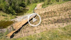
The final portion of the work will involve restoring the land as it was before excavation began. Rye will be seeded first for quick cover, followed by grass and wildflowers, using a hydroseeding machine. The pastures of the farm will be seeded with clover and timothy.
Demolishing a Bridge
A cofferdam was also required for a bridge project in Pennsylvania. This bridge demolition and replacement project was done by Deblin Inc. of Mechanicsburg, PA. The firm specializes in public works projects involving bridges and other infrastructure.
“PennDOT’s [Pennsylvania Department of Transportation’s] District 8 is our home district, and we do quite a bit
of work there,” says Tom Powell, Deblin’s vice president and the manager for this project.
The bridge that carries State Route 743—known locally as Hershey Road—crosses over the Conewago Creek. It is situated between the cities of Conewago Township (in Dauphin County) and Mount Joy Township (in Lancaster County).
Almost 14,000 vehicles travel across this bridge daily. The heavy traffic load and the years since its construction in 1940 caused the deterioration that made PennDOT declare the bridge structurally deficient and approve its replacement.
“The bridge was cast-in-place concrete, and it was in bad shape,” says Powell.
Constructing the replacement bridge cost more than $3.1 million. Work was done in two phases so the bridge could still be used while construction was going on.
“We set up temporary traffic signals at each end of the bridge,” says Powell. “Then we shifted traffic into the northbound lane and demo’d the southbound lane and part of the bridge.”
The cofferdam was set up around the bridge’s pier and abutment number 1 for this work. In the next phase it was reset so that abutment number 2 could be removed and rebuilt. In the last phase, the cofferdam was flopped to the other side. Traffic was switched to the new southbound lane, and the old northbound lane was removed and rebuilt.
The project’s challenges were “an aggressive schedule, traffic that ran pretty heavily, and a tight work area. We had access to roads on the sides of the bridge. They opened them to us and we used them as staging areas,” says Powell.
Conewago Creek’s normal depth is 6 to 7 feet. But during storms it becomes flashy because the land nearby has gentle slopes. PennDOT’s original specifications called for using sand bags and a concrete jersey bar. However, the creek’s flood depth made this idea impractical. The ground beneath the bridge had been scoured out by the creek so that it dropped off steeply. The sand bags would have had to be hand-laid, and the workers couldn’t reach high enough to lay the sand bags properly. The cofferdam was a much better solution for work in this creek.
“In rain events it gets 9 or 10 feet high because of runoff from hundreds of acres of surrounding farmland,” explains Powell. “We had several pretty hard rain events, but aside from that, weather was not a factor. We lost a couple of [work] days to hard rain.”
He adds, “Several times we were within inches of the top of the cofferdam. It was a blessing. It saved us thousands of dollars. Without it we would have been flooded out four or five times.”
Powell says that if the project site had been flooded after the formwork and rebar were already in place, “the flood would have filled the site full of dirt and rocks. We would have had to clear all that out. We’d lose days of work, thousands of dollars in manpower. The bridge replacement was [already] on a pretty aggressive schedule to have it operating by the end of the year,” so major delays would have cost Deblin a great deal of money.
The cofferdam, made by Porta Dam of Williamstown, NJ, was 10 feet tall. It measured 220 feet in length.
Powell says of the Portdam, “It’s a very good system. We’ve used it three or four times on other jobs.”
It took the crew three days each time they set up the Portadam, but only two days when they removed it. The dam was set up and removed three different times for the separate phases of the work, thus saving the expense of buying a new one each time.
Deblin’s contract with PennDOT required the company to have the new two-lane bridge ready for use by the end of 2016, in time for winter travel. By running a 50-hour workweek, the crew finished the job in November, well ahead of schedule.
During the last part of the project the approaches to both sides of the bridge will be paved.
“We’ll do permanent seeding and mulching then,” says Powell. “And within 50 feet of waterways you have to use erosion control matting.”
South Shore Keys
Aer-Flo’s Tough Guy turbidity curtains were used on a dredging project at the entryway to the South Shore Keys in South Lake Tahoe, CA. The project was done by Tahoe Marine and Excavating of Tahoe City, CA.
“We used about 500 feet of Aer-Flo turbidity curtains,” says Matt Daniels, owner of Tahoe Marine and Excavating, adding that he has used Aer-Flo curtains on various other projects.
Completed in late 2015, the project lasted about five weeks. The dredging took place in open water, about 1,000 feet out on the lake. The wind in the open area made the work challenging.
Aer-Flo’s Tough Guy turbidity curtains were supplied by the Geosynthetics Division of Reed and Graham, a family-owned asphalt and erosion control supply company in business since 1928. The Geosynthetics Division of the firm is located in Sacramento, CA. The turbidity curtains are manufactured by Aer-Flo Inc. of Bradenton, FL, at that location and at another factory in Anniston, AL.
Tough Guy turbidity curtains, also knows as turbidity barriers, are available in three types, each meeting DOT specifications. Type 1 is for areas with light winds and current velocities of less than 1 foot per second. Type 2 can handle rougher conditions, with current velocities of up to 5 feet per second. Type 3 is a special adaption of the Type 2 barrier. Approximately 20% of the area of the barrier skirt fabric is replaced with a polypropylene filter fabric.
As these four projects show, cofferdams and turbidity curtains play an essential role in controlling erosion and maintaining water quality. With environmental regulation—on both federal and state levels—not only here to stay, but likely to increase, cofferdams and turbidity curtains will continue to be useful tools.


