Stormwater runoff in Denver, CO, flows to two entities: Cherry Creek and the South Platte River. Maintaining and improving water quality in the city’s two main bodies of water is critical to Denver’s present and future.
Cherry Creek North and Cherry Creek Shopping Center are major parts of a residential and commercial district that begins five minutes from downtown Denver. The district is linked by a 22-mile bike path.
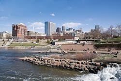
The actual Cherry Creek forms the southern border of the district. It flows northwest through Denver, turning into an urban stream. Cherry Creek joins the South Platte River at Confluence Park in central Denver, just west of downtown. This location is about 5 miles east of the foothills, near the site where the city of Denver was founded in 1858.
The South Platte River begins southwest of Denver in Park County, CO, where the South Fork and Middle Fork meet, approximately 15 miles southeast of Fairplay. From South Park, the river passes through 50 miles of the Platte Canyon.
The North Fork joins the river before it emerges from foothills southwest of Littleton, a suburb of Denver. One of the river’s seven dams, at Littleton, was built in 1965 in response to a major flood. The dam created the Chatfield Reservoir, which is a major source of drinking water for Denver.
Because floodwaters pay no heed to jurisdictional or governmental boundaries, it behooves communities to work together on preventing and managing floods. A regional agency makes such action possible, financially and physically. Denver and the communities that surround it have such an independent regional agency in the Urban Drainage and Flood Control District (UDFCD). Established by the Colorado legislature in 1969, the agency assists local governments on multi-jurisdictional drainage and flood control issues.
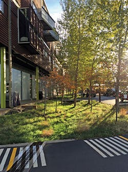
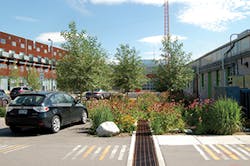
The Taxi rain swale at seven years
UDFCD covers an area of 1,608 square miles. That territory includes not only Denver, but also sections of the six counties that surround the city and all or parts of about 40 incorporated cities and towns. More than 3,500 miles of streams flow within the area. The population served by UDFCD is approximately 2.8 million people.
UDFCD has become known not only regionally but also nationally for the innovative stormwater management software it has created. These various software models are on the agency’s website and can be downloaded by anyone at no charge.
“Water quality is certainly very important. It should be taken seriously. That’s why we did this, to be sure facilities were being implemented,” says Paul Hindman, UDFCD’s executive director.
Reflecting on such matters as the need for a watershed approach to managing stormwater and the increasing use of green infrastructure, Hindman emphasizes the need to make wise choices based on carefully analyzed data. Obviously, well-designed software is a significant help in making such choices for managing stormwater effectively.
“Many people venture into this area because they’re being forced to by regulation,” he says, “but I would say that we knew it was an issue and started [working on it], so we had a jump start.”
Hindman says that all of the UDFCD software is “extremely well-received. The local governments really encourage the developers to use it so there’s some consistency in design throughout the metropolitan area.”
The district began creating modeling software in the 1970s. “We looked at hydrology modeling tools that were available nationwide and tried to evaluate what was best for us,” says Ken MacKenzie, UDFCD’s master planning program manager. “The Snyder Unit Hydrograph came the closest. We then calibrated it to local rainfall and runoff rates.”
From this work came UDFCD’s first stormwater modeling software, called Colorado Urban Hydrograph Procedure (CUHP). The original design was hand-calculated, as this was before the age of personal computers. Only mainframes were available then.
MacKenzie says the software has “gone through a number of changes, from Fortran to Fortran for PCs to a C+ version on diskette for PCs and then to a Microsoft Excel workbook. Microsoft Excel has some powerful Visual Basic programming capabilities built into it. Writing macros, which most people use it for, is only the tip of the iceberg.”
The current version of the software, coupled with the EPA’s Stormwater Management Model (SWMM) for routing, “is the only method we recommend for developing hydrology on a watershed level along the Colorado Front Range,” says MacKenzie, adding that even though the software is specific for the area with regard to rainfall and runoff rates, other communities have adopted it.
The software has changed considerably from its first version. “We do updates all the time. We try to make to make it user friendly, but get the results the local governments need,” explains Hindman.
MacKenzie says the UDFCD software is popular because of its ease of use. “There is a lot of engineering software that is not intuitive.”
Another software program available for free download is called UD-Sewer (the UD standing for urban drainage). “It uses the rational method to develop peak flow rates necessary to size a storm system,” says MacKenzie. “The real value of it is that it allows for a more economical design of a storm system. It focuses on time of concentration, so a project can use smaller pipes. It’s not really true that all of the water gets everywhere at once. Traveling time has a significant impact on the peak flow.”
Besides these two full software packages, UDFCD has developed several Excel workbooks. They are also available online for free download.
UD-Inlet is used to figure out the number and size of inlets needed along a street. It can be used for projects with typical inlets or those that need inlets with special configuration.
MacKenzie cautions, “None of the software is a substitute for engineering experience, but a junior engineer can do inlet sizing [with it]. It’s useful for most of the things we do and solves design questions with the most common projects.”
He adds, “you don’t want 100% capture, but to get the most you economically can. You want the street to carry as much as you can get it to, because it’s the most effective, and save the inlets to capture the extra flow that would otherwise render the street impassable in a flood.”
To create UD-Inlet, UDFCD built a one-third-size model of a street at Colorado State University with funding assistance from the Colorado Department of Transportation and local communities. Then engineers measured capture rates at three different longitudinal slopes and at three different cross slopes and with different inlet configurations.
UD-Detention provides guidance for sizing detention basins or retention ponds. UD-Culvert uses the HY-8 method to size culverts, but it is simpler to use.
MacKenzie says that UD-BMP is “one of the ones used most by local communities. It has worksheets for figuring extended detention, retention ponds, swales, and other BMPs.”
Hindman feels that the modeling software has increased the use of green infrastructure in stormwater management projects. He notes that the recently published manual of green infrastructure practices for urban areas is “heavily intertwined with the modeling software.”
The new manual, titled City of Denver Ultra-Urban Green Infrastructure Guide, was published in late 2015. It has 125 pages of information on green alleys, stormwater planters, and other types of green infrastructure and should increase interest in its use for stormwater management.
“There is not a concentrated effort [to push] green infrastructure here. Because there are no combined sewer systems (and overflows) in Colorado, there isn’t the regulatory driver that other cities have. Therefore it makes it harder to fund green infrastructure projects,” says MacKenzie.
He adds, “You have to show other benefits for justifying these strategies, but, as more waterways are becoming impaired, it is becoming the best way to manage stormwater in ultra-urban settings.”
Noting that Denver is not under a consent decree, Bill Wenk, FASLA, principal at Wenk Landscape Architecture & Planning, says that the city “is a bit late to the dance when it comes to participating in green infrastructure.”
Another factor that influences stormwater management and inclusion of green infrastructure in Denver is water rights law, which reflects water shortages. For all of Colorado, detention is permitted for only 72 hours for storms up to five-year storm events.
Denver has several green roofs, including those at the Denver Botanic Garden, REI, Denver Justice Center, and One Riverfront (a luxury residence building). The largest green roof in the city is above the EPA’s Region 8 headquarters. It measures 19,200 square feet and retains 80% of the rain that falls on it. Denver’s climate, though, with more than 300 days of sun per year and an annual average rainfall of just 14 inches, isn’t the best for thriving green roofs. MacKenzie says they generally have to be irrigated during dry times.
South Lincoln
Denver’s innovative stormwater projects include South Lincoln, an affordable housing project owned and operated by the Denver Housing Authority. This multiphase project is being done over several years.
Greg Dorolek, principal and project manager at Wenk Landscape Architecture & Planning, describes South Lincoln as “a four-and-a-half-block transit-oriented redevelopment. We were part of the master plan. There are seven phases of buildings. We were on four of those.”
“Our goal at South Lincoln was to include as much green infrastructure for stormwater as we could,” says Bill Wenk.
Dorolek says that the first phase—landscaping around an eight-story high-rise building for seniors and disable people—”was the tightest one. It is bioinfiltration in the city’s right of way, the first ever allowed by the Public Works Department.”
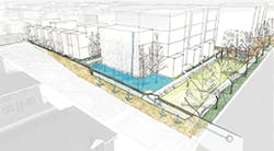
This elongated custom tree grate measures 8 feet wide by 200 feet long and is lined with green ash trees.
“We built up the soil profile and brought the root ball [of each tree] closer to the surface, a micrograde for water quality and to give the trees good growing area,” explains Dorolek. “The bioretention media is primarily sand—over 80%—and compost [to nourish the trees.]”
The second redevelopment phase at South Lincoln involved multiple buildings on different sides of the street. There was a built-in bioinfiltration area near a playground so that water-quality filtration happened on the site.
Dorolek says all of the roofs on the buildings within this site drain first to the biofiltration area. “During a major storm, runoff would flood out beyond the plants onto the grassy area.”
He adds, “You need a plant palette here that can tolerate drought and handle periodic wet times. Rains here are gone the next day.”
Plants installed in the bioinfiltration areas are a mix of upland prairie, wet meadow, and perennial types with a few willows and red dogwoods. The more than 20 species include bullrush, western wheatgrass, cordgrass, switchgrass, black-eyed susan, iris, and gamma grass. Plantings were specific to each site because water depths vary.
South Lincoln’s third phase involved a larger land area, so more drainage capacity was required. Plants installed were a grove of cottonwood trees with an understory of mixed prairie species.
Flood detention was built. The building was set back from the sidewalk so that a pocket park measuring 200 feet wide by 50 feet long was created. A StormTech detention chamber 30 inches high was installed under the lawn area. “There is no wasted space that is strictly a detention area. Even with a big storm the area will drain in two hours or less,” says Dorolek.
The underground storage lies within a rock-filled matrix. Because the native soils are very sandy, “very little, if any, stormwater gets back to the city system. Even though the existing system was old, there was no need to upgrade it,” says Dorolek.
Because there was surface drainage from the sidewalk, he says “we did use runoff reduction rate and landscape filter. We added plants in a little depression. Runoff is taken up by the plants or goes through them.”
Reducing paving allowed space for a community garden. The garden’s crushed gravel paths allow some limited infiltration.
“Significant savings were realized on this phase because no new stormwater infrastructure or outfalls were part of the project,” says Dorolek.
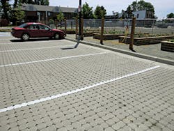
Phase one and phase three each have a 40-car parking lot with permeable pavers. The pavers in phase one are by Uni Eco-Stone from Unilock. Those in phase three are by Borgert. Both were manufactured in Colorado.
The major challenge on all of the phases of the South Lincoln redevelopment was getting city approval. “Various agencies had to review plans—public works, fire, traffic—for water quality within the right of way, fire access, maintenance, and so on. The Housing Authority took on the long-term maintenance,” says Dorolek.
Hailing Taxi
If you hear someone in Denver mention “taxi,” there’s a good chance he’s not looking for a cab. Instead, “Taxi” refers to a new urban development right along the South Platte River.
Once the site of the Yellow Cab Company, the location was used to dispatch, park, and maintain taxicabs. Now it’s an edgy urban office, residential, and retail development, built in phases by the Zeppelin Company and part of Denver’s trendy booming River North (aka RiNo) district.
“The land had all sorts of problems. It was a brownfield, and areas of it still are. It was literally flat and didn’t drain well,” says Wenk. “To create positive drainage [conventionally] we would have had to use 10,000 yards of fill material.”
Wenk’s firm began design work at Taxi in 2005. The first phase was finished in 2007.
“Taxi integrated green infrastructure BMPs within an urban redevelopment, the first in the city,” says Dorolek. The development “uses just one technique—bioretention—but it’s the way it’s integrated into the site that makes it unusual,” he notes.
The project’s main challenge was that the site is extremely flat. “We did not have the luxury of draining and putting in fill and creating slope, so the entire site surface drains,” Dorolek explains.
Within Taxi’s 20 acres are nine major areas of bioinfiltration. The largest one is 50 feet wide by 100 feet long. Other areas vary in size. Some are long narrow strips fitted in between buildings.
“Rather than collecting runoff, we were trying to infiltrate as much as possible where the raindrop fell,” says Dorolek. “The entire site acts like a sponge. We were taking advantage of sandy soil to get really good infiltration.”
The plants in the bioinfiltration areas are native river riparian grasses and naturalized ornamental flowers and shrubs. “The feeling is that it’s quite natural, even though it’s not all native plants,” says Wenk. “For cost, we seeded very small caliber trees, including cottonwoods, that are native to the Platte Valley.”
The cottonwoods are thriving now. While they do need a lot of water, Wenk says, “If you get them established, after a few years you can cut way back on the water. They get their water from the river, from the deep soil.”
Besides their beauty, the cottonwoods shade the river, “which provides a better environment for native aquatic species,” he adds. “You have to look at the long-term picture.”
The soil mixture used in the different phases of Taxi’s development has changed over the years. Time showed what worked and what didn’t deliver the expected results.
“From 2005 to 2008 we usually used a sand and peat mix for the bioretention areas. UDFCD then said that [for the sites to be more sustainable] we should find an alternative so we were not ripping up bogs and wetlands to get the peat,” recalls Dorolek. “We used sand and shredded paper for several years. It did not work well because it doesn’t hold nutrients for the plants. They were dying. For the last year and a half now we prefer to use a bioretention soil that is a sand and compost mix.”
“Taxi has become a model for other urban development. It’s been working for nine years and it’s still holding up,” he says. “It’s just shallow depressions, but they’ve become part of the river ecosystem.”
“The success of it as a pioneering way to do green infrastructure [is clear]. User acceptance and response is good from the people who work and live there,” says Dorolek.
Because no curbs or gutters or new stormwater utilities were installed, development costs at Taxi were reduced. “It was developed for $5 per square foot, not counting water and sanitary sewer, the deep lines,” says Wenk.
Besides effective stormwater management for much less, the green infrastructure also carried a bonus. It made the development more appealing to the prospective tenants Zeppelin was trying to reach: Millennials
“The developers were looking to do the right thing,” says Dorolek. “We convinced them through economic strategy that it was much cheaper than filling the site and adding gray infrastructure. Developers listen to the economic benefits.”
Northside Park
Winner of an American Society of Landscape Architects (ASLA) Merit Award for Design in 2001, Northside Park is another project by Wenk Landscape Architecture & Planning.
It’s also an amazing renovation of an ugly site.
Formerly the location of a sanitary sewer treatment plant that the city had abandoned, the 13-acre site was a blight on the nearby Globeville neighborhood in north Denver. It seemed likely to remain so, because the cost of demolishing it was too much for the city to justify spending.
Street gang members and homeless people moved in, adding to the negative image of the site. They also created public safety concerns.
A concrete channel conveyed runoff from an adjacent neighborhood to Heron Pond, which was also a brownfield. Drainage to handle this runoff had to be kept as part of the renovation.
“It was a fun design challenge,” recalls Wenk. His design replaced the concrete channel with a new soft-bottom channel and added a wetland of about 2 acres, thus creating a means to improve water quality. Cottonwood trees now 30 to 40 feet tall have grown up in the old channel.
“The wetland acts as a large sediment trap and pretreats water before it goes into Heron Pond,” says Wenk.
By demolishing only part of the old plant and incorporating part of its structure into the new park, the renovation was financially feasible. Heron Pond and surrounding areas have become magnets for wildlife. Except for two soccer fields, the park is passive, so it draws walkers and birdwatchers.
Another interesting stormwater project in Denver is at the Denver Green School, which is part of the public school system. This is a joint project of UDFCD, the Water Environment Research Foundation, and Geosyntec and OptiRTC.
A 3,000-gallon plastic cistern collects rainwater from almost the entire roof of the 8,000-square-foot building. The water is used to irrigate landscaping on the school’s campus.
“The technology that runs it is innovative. We paired rainwater harvesting with a cloud-based infrastructure automated system. It has real-time remote monitoring of the rainwater harvesting system with active controls. We installed a Web-based dashboard where we can view the amount of water in the cistern and its [filling] history,” explains MacKenzie.
“Then we linked it to the National Weather Service’s prediction system to predict how much water will fall on the school’s roof. It releases [that amount] ahead of the storm to infiltrate, then the cistern refills [from the new storm],” he continues.
Future Denver projects that will impact stormwater management include the proposed repurposing of the Denver High Line Canal as a stormwater treatment rain garden. This 66-mile-long irrigation ditch runs through the heart of the city and other suburban areas, making it a regional project.
Lined with cottonwood trees, the old canal is a favorite recreational amenity. Without water the trees will die, so various plans are being considered, such as dividing the canal into 1-mile segments so that each one becomes a detention pond.
The city recently passed a bond issue to fund development in the northernmost part of Denver County. The National Western Stock Show will anchor what will be developed as an agribusiness and agricultural educational district. This project will be a 20-year buildout.
For these projects and others, the effective stormwater modeling software is readily available from UDFCD. With emphasis on regional drainage and concerns about water shortages, Denver is likely to see that modeling result in more green infrastructure installations.
